I took my GPS on today’s orienteering event, and again it performed generally well.
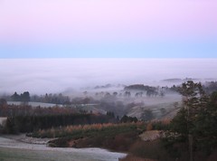
I’ll write more about the event soon, but for now, here are the “signatures” of three of my mistakes today, as captured by GPS and shown on Google Earth (in an area with low resolution satellite imagery, which is why you can’t see the individual trees.) Note the scale – it’s only about 70m from the left to the right of the photo.
 Control 10, approach from North: The Undershoot – Stopping too short, thinking you’re on the wrong line, head away, look back, oh, there it was in front of me after all.
 Control 13, approach from East: The Lack of Attack Point – Slightly off line, no plan. Realise I’ve gone too far, double back but don’t know which way to turn, so go the wrong way. Then look at map and realise what’s going on.
 Control 23, approach from West: The Overshoot – Misread map, path goes on further past the control approach than I thought – so I just turn off too late. Realise and turn around, there it is, back up the spur.
Here’s a map showing a dot for each second of the race – when the GPS receiver was able to get a fix. The start is the big green blob on the top right, the finish is the yellow blob to its left. (The trail to the north of these points is the walk to/from the assembly.) The general layout of the course is an anticlockwise loop – not a figure of eight.

The only section where there was no signal for a significant amount of time was very near the beginning – there are several gaps here. Once climbed to 170m, the signal remains good for pretty much the whole way round.