Categories
London Olympic Park

Queen Elizabeth Olympic Park – New Bridge

IMG_1461ce

There’s a new bridge into the Queen Elizabeth Olympic Park – the Monier Bridge. It connects Monier Road in Fish Island, part of Hackney Wick, with the Loop Road in the Olympic Park. At the latter connection point there is a new ramp down to the canal towpath and also a path through the Sweetwater development site, to Carpenters Lock which is the focal point of the whole park, as it connects the main north and south parts. The new bridge was actually installed a couple of years ago, but it has taken a long time to open up the area of the park north-west of the Olympic Stadium and so provide the link through to the centre.

The bridge’s design mirrors that of the Wallis Bridge which connects the northern half of Hackney Wick to the park. A map, that I found on hoardings beside another bridge in the park which is being narrowed, shows both new bridges (on the extract of the map below, they are both on the left-hand side) and also reveals new names for several other bridges in the park. The bridge to the Waterpolo arena, aka the Stratford Waterfront development site, is now called Tallow Bridge. Further downstream, the Aquatic Bridge and Purple Bridge become the Thornton Bridge and Iron Bridge respectively.

IMG_1488c

Elsewhere, I noticed that the hoardings around the Sweetwater development site have a new mural on them. There is also a new ramp down to the canal from the White Post Lane entrance, alongside the existing steep and cobbly one. There are also five new level paths connecting the canal with the old Main Press Centre building. The larger building alongside, Here East, which has previously always been a drab white and grey, has a huge “H” painted in black and green on its southern face, along with a huge “HereEast.com” graphic.

With the new bridge having opened above, and Carpenters’ Road finally reopened under the mainline railway, the Queen Elizabeth Olympic Park finally has all almost all of its entrances open – it’s somewhat challenging to count them all, but there’s at least 30 now, depending on how the boundaries are defined. Certainly, this is a big piece of London which is now a lot more connected – and a lot less secluded – than it was back in 2007.

IMG_1484ce

Categories
Olympic Park

The Orbit

13550401863_be7800f8c9_z

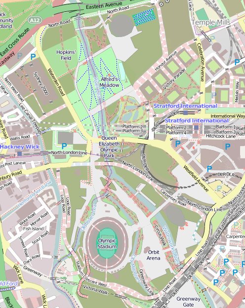
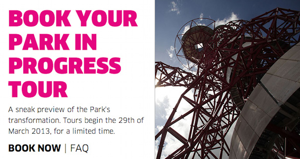
Part 2 of a writeup of a press preview tour of the Queen Elizabeth Olympic Park – thanks to Diamond Geezer for passing his invite to me – see Part 1, about the South Park itself, here.

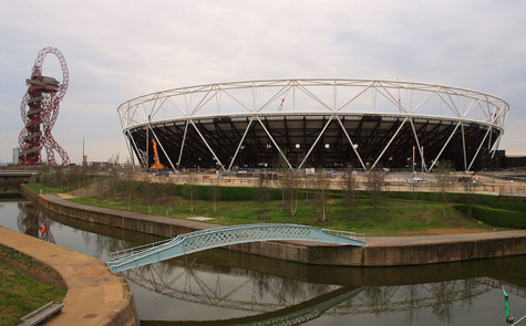
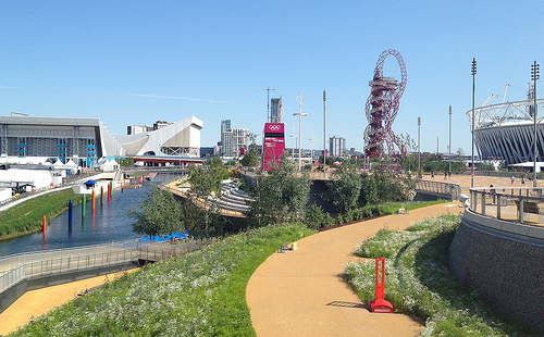
The visit to the South Park was finished up with a trip to the Orbit – the huge red sculpture that is “Marmite” to east Londoners. I hadn’t made it up during 2012 when it was last open, what with needing a combination of a timed Olympic Park ticket and a timed Orbit ticket, both tricky to obtain, with a lot of people presumably wanting to go up it to see what was going on in the Olympic Stadium. I wasn’t convinced that, with a now empty stadium being reconstructed in a park that still has a number of other “brownfield” sites, the view would be that interesting, but was very happy to be proved wrong.

The main viewing platform at the Orbit is 80 metres high – the sculpture itself being 114m tall. That’s not nearly as high as the Shard or even the London Eye, but because east London is still relatively low-rise, and because the surrounding Queen Elizabeth Olympic Park is spacious and not crowded with the buildings of an inner city, the platform gives the illusion that you are actually quite a lot higher.

13550326755_6acb06c8d6_b
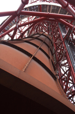
While you wait for the lift up you can admire the giant rust-coloured metal bell which fills the lower space. The sculptor insisted on total darkness within the space, so tiny pieces of light shining through rivets and welds had to be fixed, the result is a surreal experience of being below a giant bell-shaped dome, receding into darkness and apparently suspended in mid-air.

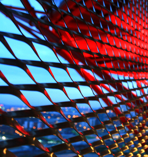
Once up in the Orbit itself, there’s a couple of outdoor platforms, facing north-west and south-east – and also an indoor space, from where you can look south-west and also to an inner void looking down the structure of the Orbit itself. The glass was a little bit dusty (maybe from the Saharan weather we have at the moment) and also somewhat reflective, so the experience is much better on the outside platforms. Semi-pro photographers might be perturbed that the outside platforms have quite small mesh fencing, so it’s difficult to poke a DSLR camera lens through for a clear shot. Plenty of space for cameraphones though. Once you’ve drunk in the view, there are a number of helpful and enthusiastic staff in the indoor space, ready to answer your questions on what you were looking at – I tested them out on their knowledge of the Crossrail portal location and the appearance of some allotment huts and they seemed to know their stuff.

13550420653_035e4acb8a_z

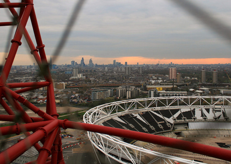
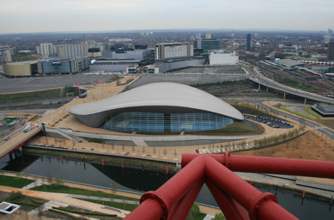
The view over into the Olympic Stadium was more complete than I was expecting – this is simply because the roof and lighting gantries are temporarily gone for the footballisation of the venue. The general city views were also excellent – the City and Canary Wharf clusters of skyscrapers being roughly the same distance away, mean they balanced rather well. Stratford itself is having a go at being a third (smaller, closer) skyscraper cluster and to some extent is managing to pull off the look. Finally, to the east the Aquatic Centre (“Come swim in the World’s Best Swimming Pool”) looks especially impressive when viewed from the Orbit – the famous, and expensive, flowing roof and huge glass side looking particularly stunning from above. Westfield is – to be honest – a bit of an eyesore from high up. Ironically, the older Stratford Shopping Centre looks more attractive, with its colourful “fish scale” wall glinting in the distance. In time, Westfield will get masked by the International Quarter development which will squeeze behind the Aquatic Centre.

13550313875_210b59a364_b

The other thing to note is it’s not all about the view. The primary purpose of the Orbit is not as a building (like the Shard) or a tourist attraction (like the London Eye) but it is first and foremost a piece of public art. A very red, rather large and not at all subtle piece, but an artwork nonetheless – and unmistakably an Anish Kapoor creation. A lot of people will look at its asymmetric, organic skyline, from a distance and think it ugly. I did and still do – from a distance. It delights in being the opposite of Paris’s Eiffel Tower, with a geometry as imperfect as possible. Up close though, it reveals itself as a very complex beast and does have a subtle beauty from certain angles.

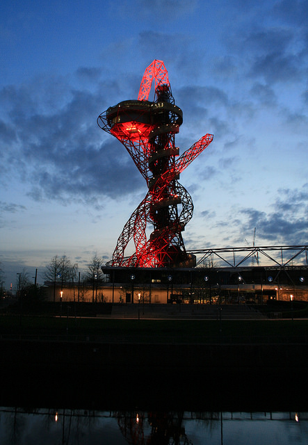
One disappointment is that the Orbit will not be open to the public in the evenings – so no great views of sunsets over central London, at least in the summer months. I suspect this is due to a nervousness that it will not attract the level of visitors needed to justify staying open in the evenings – I wonder if the struggling Cable Car has proved that not everything built in London is instantly popular. It’s a shame though as the evening is probably the best time to experience the view. Certainly, being up in the tower, when the pulsating red lights are shining on and from it in the evening, is a bit of a spectacle.

13550626594_44a448cfd2_b

Finally, getting back down is an experience in itself. First you need to pass two large distorting mirrors – a bit of a disturbing sensation if you are already on edge from the height. Then you have 445 steps down in a spiralling cage, initially anticlockwise, then doubling back. The route is not a perfect spiral, so there are some sections with a lot of empty air below the floor! You do still get a view through the cage though, and also up to the Orbit itself.

So, I’m a bit of a convert to London’s new and unsubtle sculpture, with the proviso of course that my trip to see it was free. You want to pick a day of good weather to visit, but the shape of the Orbit itself means it’s more than just another tall building to soak up a view from – the interest is as much inward to the object itself, as outward to the park and London.

All my photos from the South Park preview.

Categories
Olympic Park

South Park Opening

13549856023_749a55d723_z

It’s been nearly two years since the Games. The Olympic Park has gradually opened back up in legacy mode, but the central section, near the stadium itself, has remained closed thus far. However the section, known as the South Park, is finally reopening this weekend along with the Orbit sculpture. It’s changed quite a bit, and it’s been worth the wait. I got a preview tour of the new park on Monday – legendary local blogger Diamond Geezer was kind enough to pass his invitation on and I was only too happy to take it up.

13549758935_0274da160b_m
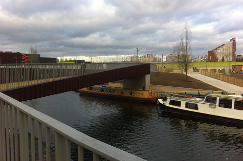
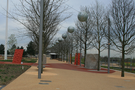
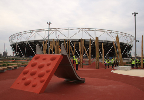
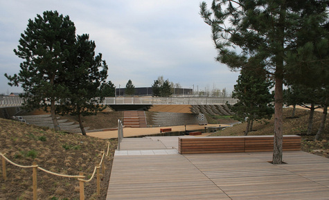
The tour itself was relatively short – after a visit to the breathtaking (and warm) Aquatic Centre, it was a wander up and down the narrow strip of parkland that sits between two water channels, with the stadium across one waterway and the Aquatic Centre beside the other. Two years ago, this was the main thoroughfare between venues in the park, built to move up to 200,000 people. Now, with the future crowd routes likely to be directly between the stadia and park entrances, the space will not see a huge level of “through” traffic and so the opportunity was taken to turn it into a rather unique park – part designer children’s playground, part traditional promenade.

13549746495_50b5df162d_z

Some of the highlights:

  • One of the five bridges that connects the park to the “Stadium” island has disappeared, and its abutment on the park has turned into a bright orange climbing wall.
  • The playground area is quite organic in feel, with strange bumps in the ground, a set of bubbles to climb to get up to the slide, and some carefully hewn rocks beside a sandpit. A fountain trickles water down one of the rocks into the sandpit – it somewhat bizarrely reminded me of a miniature version of the Princess Diana fountain in Hyde Park.
  • The playground spills over into the promenade in places, rather than being in a single place, so removing the traditional fenced off “zonal” feel of regular parks.
  • There is a small wooden outdoor stage and auditorium near the playground.
  • The area that was known as the Spotty Bridge has opened up – the bridge having metamorphosed into three narrow metallic bridges arranged in an “N” shape. In the resulting void, sets of steps lead down to the lower towpath level and, surprisingly, pine trees have been planted around the area. The strong and pleasant pine smell was not one that I have experienced in London before!
  • There is another fountain feature nearer to the Orbit and Aquatic Centre. It wasn’t working on the day of our visit, but it promises to rival the Russell Square or More London “flat ground” fountains, in terms of interactivity, on a hot day.

13549744855_077859b8a1_z

The Carpenter’s Road lock, which connects the canal and river channels together, has not been restored, which is a shame, but the Canal & River Trust who own the waterway still have plans to do so, and the passage of boats through the channel, surrounded by the three metallic bridges and the wooden seating panels, will be quite a spectacle when it all comes together.

So, although a smaller park than I was envisaging, it’s quite different to a traditional Victorian space such as the nearby Victoria Park, and certainly more interesting than a big slab of grass (you can visit Hackney Marshes for that) or a giant paved space for outdoor concerts that I had feared. It’s clear that the park designers have been enthusiastic about the project and have worked to make it distinctly modern and quite different. Best of all, it will be open 24 hours a day. The area will be gently lit at night – not too brightly as the Lea is London’s “bat motorway” apparently, but enough for it to be a welcoming space at all hours.

I was pleased, when I got home, to discover I had unwittingly taken three photos that were more-or-less the view that I had taken two years ago, shortly before the opening ceremony for London 2012:

  • View from Carpenter’s Road Lock – 2012 vs 2014.
  • The turquoise bridge – 2012 vs 2014.
  • View of the stadium from the South Park – 2012 vs 2014.

Full set of my photographs of the South Park preview here.

Part two, about the legacy-mode Orbit, to follow on Thursday.

13550059194_0da25a4cd1_z

Categories
Olympic Park OpenStreetMap

Mapping the Queen Elizabeth Olympic Park

[Updated – Event webpage here]

The southern section of the Queen Elizabeth Olympic Park opens on 5 April. Much of the northern section is already open.

I’m considering organising an OpenStreetMap mapping party (likely using Walking Papers as a basemap for people) to map the park in its new, legacy mode. Currently, much of the area is shown on OpenStreetMap as it was during London 2012, or as out-of-bounds.

The date is the evening of Wednesday 9 April from 6pm until dark (7:30pm?) followed by beers in The Crate pub. People can then add their discovered detail into the map in their own time or (if they are really keen and bring a laptop/dongle) at the pub.

Post-event pub will be The Crate pub in Hackney Wick, which is right beside an exit to the park, and is a nice pub and brewery that does great pizzas and serves some great beers brewed on site and also Dalston Cola, made just down the street by my bro. It’s a more relaxing experience than the pubs at Westfield.

Stratford is easiest to get to by tube so meeting at Westfield (ground level – that’s UP from the station exit level) at the Westfield end of the big iron bridge that goes over the station, would be the best location. I am planning on setting out from there shortly after 6pm, and then meeting people at The Crate pub (which is at the other side of the park) at 7:30-8pm. The Crate pub is near Hackney Wick station for those who don’t want to walk back across the park afterwards.

The idea is that everyone picks a slice of this cake – if we get more than 10 people, then we can double-up in the complex central sections, and if we get fewer, then we can concentrate mainly on the central area.

map_qeop

Some notes on the slices:

  • 1. Eastern part will still be a building site but plenty of detail to be both added and removed elsewhere.
  • 2. The southern half of the new South that will be newly opened, includes the Orbit and associated buildings. If time then it’s worth progressing to section 2b – unclear how much of this is open but there are a couple of new links here. The Greenway Gate area may still be inaccessible.
  • 3. Northern half of the new South Park, including the Great British Garden on the other side of the stadium. Lots of natural detail to be added.
  • 4. Not sure if the Waterglades will be open – but if not, some other new detail to add here.
  • 5. May still be under construction in places but definitely some changes from what’s on the map – even simply things like bus stops.
  • 6. The north park is already open but could do with a lot more detail, e.g. the Olympic Rings sculpture, vegetation, and link path to the north.
  • 7. Quite far away and mostly will still be a construction site. Good for someone on a bike.
  • 8. May not be too much to see here as under construction and/or fenced off for the cycling.
  • 9. This part of East Village is partially open and lots of residential detail can be added in.
  • 10. This part of the East Village is mainly closed but some bits, e.g. the park bit, are open.

I will aim to print Walking Papers maps for each of the slices and bring them to the pub.

I’ve added this to the London wiki and Lanyrd. If it’s raining cats-and-dogs on the day we can just go to the pub.

We held a similar mapping party back in late 2011, to map Westfield Stratford City. We based the party at the Cow pub on the edge of the shopping centre. Here’s a neat video that Derick created, showing the map evolving as people added to it, following the party.

Things to add to the map

  • Bus stops (& number of bus service)
  • Car parks (no. of spaces, disabled-bay information)
  • Roads and paths – particularly at park edges/entrances: official or unofficial, walking or cycling, steps
  • Vegetation – woodland, grass, garden, marsh, water
  • Individual trees, if distinctive or ‘street’ trees, ie planted in hard standing or grass
  • Facilities – toilets, concession stands, playgrounds
  • Fences, walls and gates
  • Electricity substations
  • Artworks, sculptures (with name)
  • Traffic lights, zebra crossings
  • Names of areas, places, things – many of these are new – look at what signs say
  • However do not copy names or details from official maps – these may be copyright and not open data
Categories
Leisure Olympic Park OpenStreetMap

Olympic Park Rising

7629386754_86db110501

The Olympic Park in east London was a flurry of colour and activity during a few weeks in summer 2012, but since then it has been largely locked away – a parcel of land opened last year, but with a security fence, access only from certain points and at certain hours, it hasn’t really felt like a proper park. A few cycleways have also appeared, but considering the “blank slate” of the area, they are laughably awful. Tradtionally the excuse for London’s poor standard of cycle tracks is that the roads are too narrow to fit them in, or there’s too much traffic to close a lane for cyclists. Both of these are rubbish reasons for many of our streets of course, but the lack of positive and effective action (apart from in a few isolated places) has allowed places like New York to leap-frog London as cycle friendly cities – during Autumn, more people used the bike-sharing system in New York than in London. I really hope it’s not too late to fix these mistakes.

The good news is that a lot more of the park is due to open very soon. The Aquatic Centre and the Velodrome are due to open in March, along with the outside BMX, mountain bike and road tracks. I’m rather disappointed that we’ll have to pay to use the latter, I had originally envisaged all the bridges being open to the public at all times, but with two of the bridges are forming the circuit, this will represent quite a large part of the park that is fenced off. I appreciate the venue buildings need to be self-sustaining in funding but it’s a shame that the outdoor as well as the indoor circuits are pay-to-play.

Then in April the south of the park reopens, and the Orbit. The orbit will, I’m sure, be about as popular as the cable car, at least until the view improves, but with the southern part of the park opening up, finally there will be a large, green(-ish) space which just might start to feel like a proper London park.

olympicpark_jan2014

One thing that is going to need updating is the map. The official one is really not that great (What do the dashes mean? What do the dots mean? Why are the open areas outside the park shown in the same grey as closed areas inside the park?) so we’ll have to turn to the crowdsourced map of choice, OpenStreetMap. This map (above) isn’t looking great at all either at the moment – some features that were around only in 2012, such as the athlete’s access tunnel across the Greenway, are still on there. Red dashes show out of bounds paths – how many of these will come in bounds in March/April? So we’ll need a Mapping Party some time there in April/May, and after that, the map should look pretty good.

The park was great for a few weeks in 2012, but the slow pace of opening, and the efforts so far, have been disappointing. But despite my grumbles above I’m greatly looking forward to the park opening, them sorting out the cycle lanes and access, and it maybe becoming, one day, a great space for cycling through, jogging in, or maybe even a bit of park orienteering?

Map © OpenStreetMap & contributors.

Categories
Cycling Olympic Park

Five Not-so-great Pieces of Cycling Infrastructure in London

Following on from my previous article on five great pieces of cycling infrastructure, here’s five things that didn’t make the list, and why:

Cycle Superhighways

cyclefac_cshgoogle

These were never intended to be “Dutch” fully segregated, high-capacity cycle routes. They are there to assist confident cyclists getting to work and back along the major roads. The project included reconfiguring many junctions to make them safer for cyclists too. However, too often, the “Superhighways” are just specially surfaced sections of roads, with no physical or optical barrier stopping trucks and cars driving along them. Worse, some sections are badly breaking up, with the surface disintegrating – most likely due to motorised traffic rather than the bicycles themselves. I understand that the project included funds to keep these maintained but that’s clearly not happening.

A real Cycle Superhighway would have been a lane in each road closing to motor traffic, which is happening in other cities (Vancouver, Washington DC to name but two). But with one measure of the transport authority’s performance being the average speed of traffic across its network, this was never likely to happen on the trunk roads.

Tavistock Place / Torrington Place Cycleway

cyclefac_tavistock

A very well used two-way cycle facility on a key east-west cycle route in London, the cyclists’ parallel to the heavily trafficked Euston Road. Sadly it is so busy with cyclists now that, at rush hour, with the lane only wide enough for one bicycle, the queues can stretch back beyond the previous junction. It’s therefore faster to cycle along the road during the rush hour – except you get hassled by taxis and other traffic when you do, because apparently the rest of the road is out of bounds to cyclists if there’s a cycleway.

The cycleway also includes an odd section where the two cycle lanes pass each other on their left – minor cycle-cycle collisions are frequent. Pedestrians often also cross the lanes without looking, with poor sight-lines, resulting in frequent frustrated yells from oncoming cyclists. The route needs the Royal College Street armadillo treatment, and the Camden Cycle Campaign has recently launched a project to encourage this to happen.

One-way Streets, even for Cyclists

cyclefac_oneway

Encouragingly, two-way cycling on one-way streets is happening in quite a few places now – Hackney borough and the City of London Corporation, in particularly, have been taking the simple steps to allow quiet roads to be one-way for traffic, but two way for cyclists, without building complicated and often unnecessary dedicated cycle routes. Most European cities – Paris, Brussels and Vienna to name but three, are full of these kinds of streets. However, in London a great many side streets remain as impermeable for narrow bicycles as they do for big cars and trucks. There is often no reason why other than historical convention.

Cycle Routes in the Olympic Park / East Village

cyclefac_olympic

A whole brand-new neighbourhood being created, and a great chance to create a sustainable transport utopia, along with direct, spacious cycleways between east and central London, avoiding the traditional big roads? It’s still early days, but it doesn’t look like it’s going to happen. There’s just the “usual” cycle lanes which cars can drive in. There are a few dedicated sections, which are wide and straight, but it’s not all joined up. A real missed opportunity.

Removal of Cycle Paths

broadlane

For streets managed by the central transport authority, rather than the individual boroughs, it seems that dedicated bicycle paths are out of fashion. The photo shows a cycle path on a wide pavement, about to be bulldozed away. It was never a great path, and not particularly popularly used (and often walked upon by pedestrians, hence the sign here), but it was still better than being on the road with the traffic. Original plans for the road rebuild here showed the cycle path being retained (Map D) but the plans were quietly updated and now show it gone. It will be replaced by a wide pavement with trees, the three-lane one-way road beside going to a two-lane two-way road. You can tell its a centrally managed street, by the way, because of the lines on the edge of the street being pink rather than yellow.

There are other examples of junction rebuilds happening where dedicated infrastructure for cyclists appears to be being designed out.

First three photos: Google Streetview. Fourth photograph: Diamond Geezer.

Categories
Olympic Park

Olympic Park Mini-Update

opu_march2013

I recently headed down the Lea Valley for a short visit to Stratford City (thanks to their Sundays-until-6pm policy when most other large retail areas close at 5pm) and spotted a few changes, + a couple I saw from another recent cycle down the Lee Navigation towpath and one extra one I spotted from reading a newspaper article just now:

  • Bicycles (but not pedestrians – no pavements) can finally use the Northern Retail Lifeline. Or, at least, I got through on my bike. It might have been because the people at the security box that had always blocked me previously had gone home at that time on a Sunday evening though. The Northern Retail Lifeline is the wiggly link road going from the A12 to Stratford City. This is its official name – it appears on a roadsign at its northern end. Its windy course through the Olympic Park means you get a nice close-up view of a lot of the post-Olympic redevelopment.
  • Apparently Waterden Way, a more direct access from the north than the Northern Retail Lifeline, will open in May and will include fully segregated bike lanes. Hopefully these will be better than the laughable pavement/cobbled bike lanes surrounding Stratford City as it stands. That is, at road level, straight, and with a step up/down barrier to the traffic. We shall see.
  • The Velodrome is looking really good as ever.
  • The area where the Riverbank Arena was (for hockey) is extremly churned up, looking almost apocalyptic.
  • The shell of the Basketball Arena remains, but is disappearing quite quickly. Same at the Waterpolo Arena.
  • Most of the seating wings for the Aquatic Centre remain.
  • The Village Operational Support Area in Leyton has completely disappeared, fence and all.
  • Most of the rest of the security fence around the Olympic Park remains, including the electric fencing, CCTV and microwave detectors. I understood why it was that extreme before/during the Olympics, and appreciate that the (de)construction needs a decent barrier, but the continuing overbearing nature of it is pretty horrible. They could have least removed the top (electric) bit by now.
  • The Media Catering Village has also disappeared. I know this doesn’t sound that exciting, but it was a pretty substantial three-story building that I spent up to an hour in during every Gamesmaker shift. Incidentally, like many London 2012 things, it was massively over-specced, I never saw the Gamesmaker area more than 30% full and the press dining areas were never more than 10% full. The MacDonalds underneath was packed though.
  • The two new pedestrian bridges across the Lee Canal are still looking very unconnected.
  • Temple Mills Lane is still looking extremely firmly closed, the gate at the eastern end at least shows no sign of opening anytime soon. I had previous thought it might open this spring.
  • I spotted my first signpost pointing to the “Queen Elizabeth Olympic Park”. It was a cyclists’ signpost and was in Highbury (!).
  • Stratford City is very busy at 5:45pm on a Sunday evening.

A few other related bits and pieces:

  • I didn’t get in the ballot for Ride London 100, which will start in the Olympic Park this summer.
  • Here’s a site dedicated to reporting what happens in the Olympic Park now. Good stuff.
  • Hackney Council want to hold large scale events on Hackney Marshes every summer, following the Hackney Weekend event last June. Personally I can’t think of anything worse. Pretty much the whole marsh was sealed off for a month before, and a couple of weeks after, meaning that my local parkrun event had to be cancelled during that time. I would be more supportive if the setup/takedown process was done in a week or so, but six weeks is just ridiculous. There’s a perfectly good venue being created, less than a mile to the south-east of Hackney Marshes…

Basemap (c) OpenStreetMap contributors.

Categories
Olympic Park

Back in the Park?

piptour

Well last year was the year that the Olympic Park was seen in all its glory. Since then, the gates have been firmly shut and the electric fencing remains about the perimeter. I’ve touched briefly on the schedule for the walls coming down and the park reopening, but it’s this summer before the first bit opens.

However, you can get in now for a sneak peak. Initially, it looked like the free bus tours, which operated during the main “Big Build” before the Olympics, and which I went on a couple of times in 2010 and 2011, were coming back in their traditional form. They would probably be less exciting than during the construction phase, as deconstruction is inevitably less interesting. However since then there appears to have been a slight change in strategy.

Now, the tours have been rebranded Park in Progress and are £15 – which doesn’t sound good. But when you look closely, the bus tour is essentially to get you to the base of the Orbit tower, from which you can climb up and take in the view. The Orbit cost £15 during the Olympics itself, but you also needed a ticket to get in the Olympic Park in the first place, and that was the difficult bit, if you weren’t an appropriately accredited Gamesmaker. Now, it’s much easier to get there – and for groups the price drops to around £10/head, with it being cheaper still for children. Not too bad. Slightly cheekily, they won’t give you a refund if the Orbit is closed due to high winds – but they’ll try and book you on a later tour.

Here’s what the park looked like just before the Olympic Games last year.

Categories
Olympic Park

Legacy Timetable

Here’s the announced timetable for the transition and reopening of the Olympic Park and a few other Olympic-related venues:

  • 8 September 2012 – Lea Valley Whitewater Centre reopens
  • 10 September 2012 – Lee Navigation Towpath reopens
  • Late September 2012 – Northern Retail Lifeline and Angel Road access to Stratford City reopens
  • 30 September 2012 – The Greenway (except at Stratford High Street) and the View Tube reopens (some reports say the beginning of December instead.)
  • February 2013 – Canal Park opens
  • Spring 2013 – Temple Mill Lane reopens
  • 27 July 2013 – North Park and Multi-Use Arena (aka Copper Box) reopens, London Lions move into the Copper Box, Waterden Road opens
  • Summer 2013 – East Village (aka the Olympic Village)opens
  • 4 August 2013 – Ride London race starts from the Olympic Park
  • September 2013 – East Marsh reopens
  • December 2013 – Velo Park and Eton Manor reopens
  • Early 2014 – White Post Lane reopens
  • March 2014 – South Plaza, Aquatics Centre, Orbit, IBC/MPC reopens (although this brochure says 2013 for the Orbit and the South Plaza
  • August 2014 – Stadium reopens
  • Late 2014 – The Greenway (at Stratford High Street) reopens
  • 2014 – First houses in Chobham Manor (site of the Basketball Arena) finished

Categories
Olympic Park

A Change of Direction

Regular readers will have noticed that my last seven posts, and the great majority of posts this year, have been about the Olympic Games – specifically, the Olympic Park in East London. I’ve been pretty excited about London 2012, but I’m just as excited about what comes next for the Queen Elizabeth Olympic Park, to give it its post-games name. Yep Sport started as an orienteering events and training blog – but Attackpoint largely serves that purpose for me now, so while I’ll continue to mention orienteering, cycling, running, hillwalking and OpenStreetMap from time-to-time, I’m going to focus more closely on what happens to the Olympic Park in the next few years – and not just because I think it will make an amazing venue for a future orienteering race to complement the City Race that I co-founded in 2008.

I already have a couple of ties to the Olympic Park. Until recently, I lived just the other side of Victoria Park, and could see the lighting gantries of the Olympic Stadium, under construction, from my kitchen window. I’m now further up the Lea Valley but still just a short cycle ride away from the Park. Also I was responsible for naming one of the five neighbourhoods that will be built, over the next 15 years, in the park – namely East Wick – it’s the bit east of Hackney Wick appropriately enough, and I like the name “Wick” as I spent a year near Wick in the far north of Scotland. Coincidently, my current duties as an Olympic volunteer, or Games Maker, have me working by the International Broadcast Centre (IBC) in the north-west part of the park – which is the bit that will become East Wick.

At the moment I’m gathering some links relevant to the legacy plans for the park.

Top: CGI image from the LLDC website. Bottom: Aerial image of the park just before the Olympic Games, from Google Maps.