Categories
Orienteering

City of London Map – Sneaky Peak

Here’s a Christmas present – a peak at a partially completed small section of the City of London map. Scale: 1:625 at if viewed on a 72dpi screen.

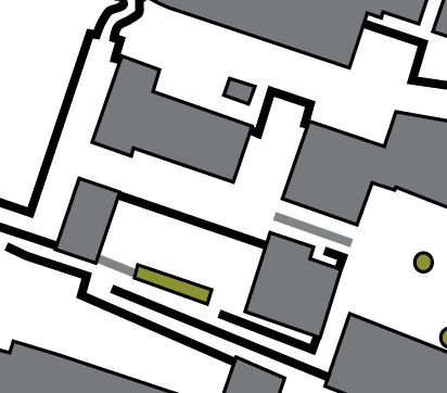
What’s shown: Buildings, passable and impassable walls/fences, and flower beds.

What’s not shown: Roads & pavement boundaries, underpasses, out of bounds areas, steps*. A couple of short walls are also missing.

* I hate drawing steps. Really, they are the most tedious part of creating orienteering maps. So, generally, they are the last thing I draw when doing the cartography.

Categories
Notes

Google Maps API – Terrain Maps

Google has added Terrain Maps – physical maps with relief shading based on a DEM (Digital Elevation Model) – to the Google Maps API, and they look beautiful. I’ve set them as the default map displayed on my Fixtures Map, because they are clear and uncluttered, while at the same time giving a good indication of the hilliness and terrain type of a particular area.

I also took the opportunity to upgrade the Fixtures Map to version 2 of the Google Maps API. According to Google, this offers a “much smaller JavaScript download” and “two additional satellite zoom levels”, amongst other things.

Categories
Notes

Name That Building

Here’s a building – actually two, the main one is on the left – as seen on an orienteering map. Dark grey = building, Light grey = canopy.

Hint 1: In the City of London.
Hint 2: Very tall building.
Hint 3: Very new.
Hint 4: Very cool.
Hint 5: Overlooking a cartographer’s nightmare.

What building is it?

Mystery building