Categories
OpenStreetMap Orienteering

OpenOrienteeringMap v2.Beta

oom2_gui

About a year ago, I mentioned that I would be spending a bit of time rewriting OpenOrienteeringMap (OOM). The web application, which people use to create printable simple “street orienteering” (or Street-O) maps for use in low-key events such as the SLOW Street-O series events, has been around for a bit, and was not the most intuitive or prettiest application to use.

More seriously, the map creation process had little in the way of safety checking, meaning that mistakes could be made – one recent Street-O event I went to had two control points with the same number, and another one had misaligned the control “clue sheet”, so that the clues corresponded to the wrong control – resulting in much confusion out on the course. There was also a popular complaint from course planners – namely that they couldn’t go back and change their map – if they made one slight misplacement or misnumbering, they would have to start all over again from the beginning. A less frequent but still valid complaint was that it was easy for control numbers to overlap (or be near) other control circles, causing confusion. There was a non-trivial workaround for this last point. The new version, which I’m releasing today as a beta (while it awaits final signoff) addresses all these issues and has a few more features.

If you want to jump right in, then have a play now at http://oomap.co.uk/ – or read on for more details of what’s new.

oom2_newcontrol

A list of the main new and updated things:

  • Much more intuitive to use.
  • Set a direction for the control number.
  • Set a point score and control description, for use with the new clue sheet.
  • Edit and delete controls after they are created.
  • You can now move the map incrementally (drag the blue move marker.)
  • Validator to make sure duplicate numbers are not entered!
  • You now get given a code when saving a map. Copy this code somewhere, and use it to reload your map in the future.
  • New clue sheet which can be edited and printed – useful in conjunction with the map, for an event.
  • New design for the PDF maps – with British Orienteering branding.
  • The standard Street-O map now shows parks (yellow) and forests (light green). If you don’t like them, use Street-O basic, which leaves them out, as well as railways.
  • Daily updates to the background map.
oom2_save

A note on schedules for updates to the background map, which is created from a local database based on the data in the OpenStreetMap database:

  • The local database is now updated from OpenStreetMap every day between 6am and 8am. During this time, OpenOrienteeringMap is not available for use – the maps on the website will appear partially or completely blank and PDF generation will not work.
  • The map data is based on what is in OpenStreetMap up to and including 7pm the previous day.
  • This means that edits to the background map in OpenStreetMap should take between 13 and 37 hours to appear in OpenOrienteeringMap.
  • The image “tiles” of the map that you see on the OOM website are created on-the-fly from the local database and cached for quicker future viewing – the cache is emptied daily at the same time as the map data is updated.
  • The PDF map is always created on-the-fly from the data, and not cached.
  • The process is subject to occasional delays and may stop altogether for a while if upstream processes/timescales change.
  • I’m using Geofabrik’s download service – thanks guys!
oom2_cluesheet

Unfortunately this new version (and the old one) will only be available for the UK (& Ireland) at the moment. Partly this is because the new site is very UK-centric – it searches for UK postcodes, takes advantage of freely available contour line vectors for Great Britain, and is branded as a British Orienteering product. But the main reason is that the OpenStreetMap dataset for the whole world is huge, it’s unwieldy and almost unmanageable – not to mention requiring many hundreds of gigabytes of expensive server disk space, and a lot of RAM. The UK/Ireland cut, on the other hand, is much more straightforward to handle.

oom2_pdf

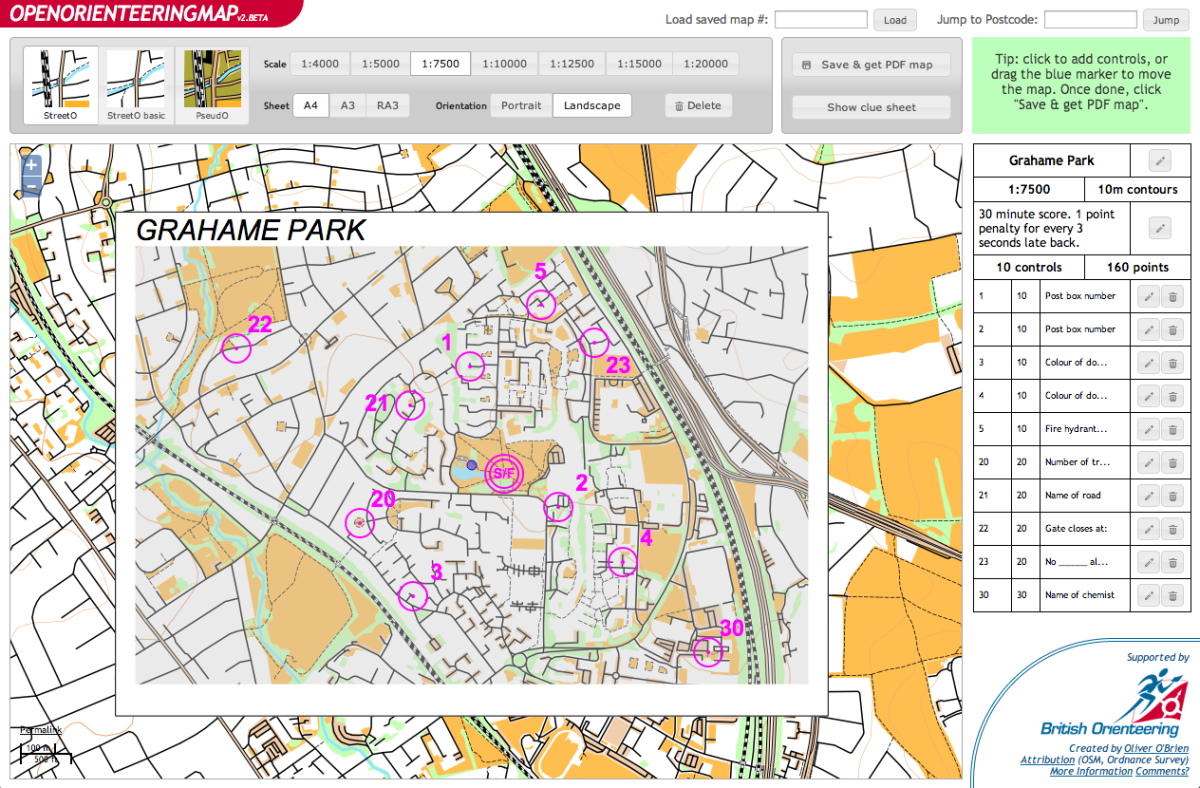
You can download this example PDF, which is of Grahame Park in north-west London, here.

Get started making your own Street-O map, at http://oomap.co.uk/. Your comments are, as ever, welcomed below.

[Update – fixed the following bugs: Western Ireland not being rendered, clue sheet labels in the wrong order, not being able to edit a control until at least one is added (problem when loading in a previously saved map), permalinks not using WGS84 lat/lon.]

Categories
Data Graphics London

London’s Oyster Card Tidal Flow

Here is an animation I created a couple of years ago, one of a number I created for the “Sense and the City” exhibition at the London Transport Museum, which ran from Summer 2011 to Spring 2012. A version of this animation was branded appropriately for the exhibition and shown upstairs in the interactive section. I also created a similar animation of the Barclays Cycle Hire, and colleagues created other map-based visualisations of the moving city.

The animated map shows the touch-ins (going into the network) and touch-outs (leaving the network) of Oyster cards at London’s tube and train stations, including a few beyond the Greater London boundary which still accept Oyster cards. Oyster cards are London’s travel smartcards. As the animation moves forwards in 10-minute intervals during the typical weekday, the balance between touch-ins and touch-outs is shown by a colour scale. Red indicates the great majority of taps are touch-ins, and green indicates mainly touch-outs. White is the “neutral” colour, indicating that roughly as many people are entering the network as leaving it, at that period in time.

Categories
Olympic Park

Olympic Park Mini-Update

opu_march2013

I recently headed down the Lea Valley for a short visit to Stratford City (thanks to their Sundays-until-6pm policy when most other large retail areas close at 5pm) and spotted a few changes, + a couple I saw from another recent cycle down the Lee Navigation towpath and one extra one I spotted from reading a newspaper article just now:

  • Bicycles (but not pedestrians – no pavements) can finally use the Northern Retail Lifeline. Or, at least, I got through on my bike. It might have been because the people at the security box that had always blocked me previously had gone home at that time on a Sunday evening though. The Northern Retail Lifeline is the wiggly link road going from the A12 to Stratford City. This is its official name – it appears on a roadsign at its northern end. Its windy course through the Olympic Park means you get a nice close-up view of a lot of the post-Olympic redevelopment.
  • Apparently Waterden Way, a more direct access from the north than the Northern Retail Lifeline, will open in May and will include fully segregated bike lanes. Hopefully these will be better than the laughable pavement/cobbled bike lanes surrounding Stratford City as it stands. That is, at road level, straight, and with a step up/down barrier to the traffic. We shall see.
  • The Velodrome is looking really good as ever.
  • The area where the Riverbank Arena was (for hockey) is extremly churned up, looking almost apocalyptic.
  • The shell of the Basketball Arena remains, but is disappearing quite quickly. Same at the Waterpolo Arena.
  • Most of the seating wings for the Aquatic Centre remain.
  • The Village Operational Support Area in Leyton has completely disappeared, fence and all.
  • Most of the rest of the security fence around the Olympic Park remains, including the electric fencing, CCTV and microwave detectors. I understood why it was that extreme before/during the Olympics, and appreciate that the (de)construction needs a decent barrier, but the continuing overbearing nature of it is pretty horrible. They could have least removed the top (electric) bit by now.
  • The Media Catering Village has also disappeared. I know this doesn’t sound that exciting, but it was a pretty substantial three-story building that I spent up to an hour in during every Gamesmaker shift. Incidentally, like many London 2012 things, it was massively over-specced, I never saw the Gamesmaker area more than 30% full and the press dining areas were never more than 10% full. The MacDonalds underneath was packed though.
  • The two new pedestrian bridges across the Lee Canal are still looking very unconnected.
  • Temple Mills Lane is still looking extremely firmly closed, the gate at the eastern end at least shows no sign of opening anytime soon. I had previous thought it might open this spring.
  • I spotted my first signpost pointing to the “Queen Elizabeth Olympic Park”. It was a cyclists’ signpost and was in Highbury (!).
  • Stratford City is very busy at 5:45pm on a Sunday evening.

A few other related bits and pieces:

  • I didn’t get in the ballot for Ride London 100, which will start in the Olympic Park this summer.
  • Here’s a site dedicated to reporting what happens in the Olympic Park now. Good stuff.
  • Hackney Council want to hold large scale events on Hackney Marshes every summer, following the Hackney Weekend event last June. Personally I can’t think of anything worse. Pretty much the whole marsh was sealed off for a month before, and a couple of weeks after, meaning that my local parkrun event had to be cancelled during that time. I would be more supportive if the setup/takedown process was done in a week or so, but six weeks is just ridiculous. There’s a perfectly good venue being created, less than a mile to the south-east of Hackney Marshes…

Basemap (c) OpenStreetMap contributors.

Categories
Notes

The Information Continuum

So Google Reader is closing this summer. That’s a shame. It’s been my RSS feed reader for many years. I’m currently subscribed to 163 feeds, split across London, Tech, Mac, GIS, InfoVis, financial, orienteering and general. For a while I had a specially crafted Twitter search that fed tweets into Google Reader, but I eventually realised (when this overwhelmed the reader with the volume of tweets coming in) that mixing Twitter and feed reading is not a good idea. They serve slightly different purposes.

One of the feeds I follow has suggested that, if I don’t switch feed reader, then there are other ways to keep updated – weekly email newsletters, Facebook update and Twitter updates. The thing is, none of these get quite the same level of attention: There is a continuum of information that RSS fits into.

Google Reader sits squarely between these other ways I could absorb information, but each has their own problems:

* Email – I normally get about 20-100 a day. These normally get read within a few hours of being sent, and will generally then sit in my inbox until I’ve around to filing them and replying to them – this might be a couple of months in extreme cases. The problem is that as a personal copy of each email has been delivered to you, and takes up (account) space. I feel compelled to just not let it sit there in the inbox forever.

* Google Reader – generally about 20-50 a day. I don’t feel the need to read everything, but I’ll read most recent stories if bored. Probably about 50% get read. if I particularly like a story, I’ll star it – I maybe do this on 1% of stories. But otherwise they just scroll of to the bottom.

* Facebook Updates – Facebook keeps changing the rules and algos, so it’s quite possible that, unless you pay for advertising and prominent placement, your story which you push to a Page that I subscribe to, won’t actually get seen, unless I proactively go to the Page or view my Pages tab which is obscure. It’s not a reliable free way to see content.

* Tweets – I follow around 600 people and so probably get about 2000 a day, i.e. 1-2 a minute – much higher during the afternoon than the morning or night. There’s no way I’ll see everything.

Here’s the best way to the worst way that I will see/know/act on something – the continuum of information.

  • Face to face – obviously. Unless I’m trying to concentrate on simething else!
  • Postal mail – it sits on my desk at home filling up space until I do something about it
  • Phoning me – I can’t miss it but I might forget about it
  • Tweeting me – unless I’ve done something very popular, these will generally get seen
  • Mobile texts – require me to either action then, or forget but re-remember
  • Facebook IM
  • Work Email – will read and forget, then eventually file/reply
  • Personal Email – will read and forget, then eventually file/reply
  • Facebook Mail
  • DMing me on Twitter – Twitter/clients are starting make this harder to see/remember
  • FlickrMail
  • RSS (Google Reader) – Fills an important space – I curated my view, so it is the most likely way I’ll read things that are not specifically directed to me.
  • Facebook Groups – The most read non-personal content on Facebook, thanks partly to email/text notifications
  • Facebook Newsfeed – I check it a lot less than Twitter but it’s also less noisy
  • Twitter Timeline – too many tweets come in and scroll off too quickly
  • Comment on my blog – thanks to a non-functioning mailserver.
  • Facebook Pages – stories here tend to not get viewed unless paid-placement
  • Websites – I actually have to visit them. This doesn’t stop me viewing a few key websites (BBC News, Diamond Geezer, Nopesport, Reddit London are my top four) almost every day.
Categories
London

Rename a Tube Station!

If you could rename a London tube (or DLR/Overground) station, what would you rename it to and why?

I would rename the following:

5641085817_6f9c5c1460_n

  • Aldgate East to Brick Lane
    Why? To promote a famous street and important tourist attraction for Tower Hamlets, and to distinguish it better from the nearby “Aldgate” station. (link)
  • Stratford International to East Village
    Why? International trains aren’t going to be stopping at Stratford International any time soon, so why not name it after what is surrounding it – East Village (formerly the Athletes’ Village) or Queen Elizabeth Olympic Park – although the latter is a bit long. Alternatively Stratford Olympia?
  • Paddington (H&C/Circle) to Paddington Basin
    Why? The two Paddington Underground stations a separate and a long walk from each other. Importantly, tourists getting going to the other Paddington Underground station, to go east, will have to get off after one stop anyway, and change at Edgware Road – a hassle.
  • Paddington (Bakerloo/District) to Praed Street
    Why? Same reason as above – to distinguish the stations more and make it less confusing to tourists arriving from Heathrow Airport. It used to be called Paddington (Praed Street) anyway.
  • Euston Square to Gower Street
    Why? It used to be called Gower Street, and it’s on the latter street, not Euston Square. Plus it’s a block away from Euston station, although it might be connected in the future if/when High Speed 2 happens.
  • Tottenham Court Road to Centrepoint
  • Why? It’s at the far end of Tottenham Court Road – so not much use for someone wanting to be at the north end of the road. Plus it’s right by the Centrepoint tower and could be considered to be the centre station on the tube network – the crossing point of the North-South Northern Line (Charing Cross Branch) and the East-West Central Line.

Photo CC-NC-By-SA-ND Chris Beckett.