Categories
Data Graphics London

Tube Colours

[If you are looking for my London Tube Stats interactive map, it’s now here.]

Transport for London (TfL) take their colours extremely seriously – the London Underground, in particularly, uses colour extensively to brand each line, and the maps and liveries are very well known.

The organisation has a colour guide to ensure that, when referencing the tube lines, the correct colour is used. Somewhat surprisingly, the guide includes hexadecimal (i.e. web) colours for only a “safe” palette – i.e. colours which would definitely work in very old web browsers. They don’t list the “true” hexadecimal for the colours, even though, confusingly, the colour shown is the true one. I couldn’t find anywhere on the web that did this either, all in one place, so here below is a summary. I’ve also included the safe colours so you can see the difference – but don’t use these unless you have to.

Line True Hexadecimal Web Safe Hexadecimal
Bakerloo #B36305 #996633
Central #E32017 #CC3333
Circle #FFD300 #FFCC00
District #00782A #006633
Hammersmith and City #F3A9BB #CC9999
Jubilee #A0A5A9 #868F98
Metropolitan #9B0056 #660066
Northern #000000 #000000
Piccadilly #003688 #000099
Victoria #0098D4 #0099CC
Waterloo and City #95CDBA #66CCCC
DLR #00A4A7 #009999
Overground #EE7C0E #FF6600
Tramlink #84B817 #66CC00
Cable Car #E21836
Crossrail #7156A5

All the colours above can be found on my new Electric Tube print.

Categories
Data Graphics

Mappiness – A Personal Mood Map

The Mappiness project is run by one of CASA’s technology superstars Dr George MacKerron – it was his Ph.D project at LSE. The project, which is still going, aims to quantify happiness based on environmental factors, such as location, views and sound, as well as who people are with and what they are doing. Data is collected by volunteers downloading an iPhone app, which then pings them at random moments twice a day between 8am and 11pm (configurable) to ask them the questions and collect the data. Volunteer incentive is driven by having access to a personal webpage which contains all their collected data, visualised in a wealth of attractive graphs and maps.

I’ve been using the app since late October, it has been steadily pinging me twice a day since then, and most of the time I hear the familiar ‘ding ding’ and get around to recording the information. With around 160 responses, some interesting insights are now appearing, some(!) of which are non-personal enough to share here. The map above shows the locations where I was pinged, for the London area – yellow stars indicate where a photo was taken.

Here’s one, based on the general environment:

Perhaps more interesting is that I spend much less time outdoors than I thought. The app (by default) only asks for a picture if you are outdoors, so by counting the number of pictures that appear on my personal webpage – just 14 out of 161 – this in theory means that I spend only 8-9% of my waking life outside. This percentage will hopefully grow as summer approaches and things start to warm up again.

Because I don’t get to choose when to post the images, the photos are a good snapshot of my “everyday” outdoor view, rather than a nice or interesting place that I would specifically stop to photograph. Here’s a couple of my most recent ones:

One of Dr MacKerron’s current projects involves using Microsoft Kinect sensors for visualisation – this is my very tenuous link to allow me to post the image below, which is a 3D grid “photograph” of me at my desk, constructed from Kinect data.

Mappiness managed to choose to ping me this morning precisely at the moment that my bike chain snapped, on the way to work. Needless to say, a low score for happiness was recorded.

Map background Copyright Google.

Categories
Orienteering

The State of British Orienteering, in Wordles

Here’s some Wordles that I’ve created with the runs and events data available on the British Orienteering website, based on 166,000 runs on 5000 courses across 600 events between January 2010 and now.

1. Courses put on by clubs:

vs Actual runs done, by course:

…which shows that we put on a lot of Orange and Yellow courses, but really everyone wants to run Green or Blue.

2. Actual runs done, by club of the runner:

vs Actual runs done, by organising club:

…which shows that some clubs are mainly about organising events (e.g. HOC), some are mainly about running in events (e.g. BOK), but most are about both.

3. Finally – which regions see the most number of runs?

S(OA) = Scotland, W = Wales. The rest are English regions: NE/NW/SE/SW, EA (East Anglia), SC = (South Central), YH (Yorkshire/Humberside), EM/WM (E/W Midlands). While large events that rotate around the regions on a multi-year timetable will distort this, some very large events (e.g. the Scottish 6 Days) don’t appear on British Orienteering’s system as having a region associated with them, so will not appear in the above Wordle.

Categories
Bike Share Data Graphics

Bike Share Route Fluxes

Capital Bikeshare, the bike sharing system for Washington DC and Arlington, recently released the data on their first 1.3 million journeys. Boston’s Hubway bike sharing system also released journey data for around 5000 journeys across an October weekend, as part of a visualisation competition. Both these data releases sit alongside London’s Barclays Cycle Hire scheme, which also released data on around 3.2 million journeys made during the first part of last year.

Taking together all these data sets, I’ve used Routino and OpenStreetMap data to suggest likely routes taken for each recorded journey. This same set of data was used for Martin Zaltz Austwick’s excellent animation of bikes going around London streets. I’ve then built another set of data, an node/edge list, showing how many bike sharing bikes have probably travelled along each section of road. Finally, I’ve used node/edge visualiser Gephi and its Geo Layout plugin to visualise the sets of edges. The resulting maps here are presented below without embellishment, contextual information, scale or legend (for which I apologise – unfortunately this isn’t my current primary work focus so my time on it is restricted.)

For the two American schemes featured here, I have set the Routino profiler to not use trunk roads. Unlike most UK trunk roads, American trunk roads (“freeways”?) appear to be almost as big as our motorways, and I expect you wouldn’t find bikes on them. Unfortunately there are some gaps in the Washington DC data, which does show some cycle-lane bridges alongside such freeways, but these aren’t always connected to roads at either end or to other parts of the cycle network, so my router doesn’t discover them. This means that only a few crossings between Virginia and Washington DC are shown, whereas actually more direct ones are likely to be also in use. The profile also over-rewards cycleways – yes these are popular but probably not quite as popular as the distinctive one in the centre of Washington DC (15th Street North West) showing up as a very fat red line, suggests. The highlighting of other errors in the comments on this post is welcomed, I may optimise the profiler (or even edit OpenStreetMap a bit, if appropriate) and have another shot.

London:

Washington DC:

Boston:

Categories
Mashups OpenStreetMap

Run Every Street in Edinburgh – in Strict Alphabetical Order

…it sounds like one heck of a lot of running. But Murray Strain, one of Scotland’s top terrain runners, is counting on it for his basic training. He’s logging the whole venture, which is based on his trusty Edinburgh A-Z. If two adjacent streets with very similar names are nonetheless separated in the A-Z index by one on the far side of the city, it means a couple of legs right across the city.

Since he started the exercise last year Murray’s got through all the As, and is currently midway through the Bs. I’ve produce a couple of GEMMA maps, one showing the A-Bs (above, As are red and Bs are orange) and one showing the A-Gs (below, in rainbow order). That’s a lot of streets. N.B. The maps in fact show all linear features in the area in OpenStreetMap, so the odd named cycleway and waterway has crept in there too. But the ~95% of the coloured lines will be the streets that Murray will be run.

In order to produce the map, I’ve added a new feature to GEMMA – it now allows you specify only one desired geometry type, i.e. points, lines OR polygons, when adding an OpenStreetMap layer to your map. Previously, you got all three types, although you could reduce each to a dot if desired. This example also highlights the need for legends on the PDF maps that GEMMA produces – a larger coding change, so one that would make it into a future version 2 of GEMMA.

Categories
Notes

MOO Facebook Cards

My 50 new MOO Facebook cards arrived today – I ordered them on Thursday last week, taking advantage of the first 200,000 sets ordered being free. The cards are auto-created from my Facebook profile, the builder then allows you to further customise them. Note you need to have a new-style Timeline profile on Facebook to work – not everyone has been offered the option to upgrade to this yet.

I’m particularly impressed with the quality of the paper the cards are printed on – a nice, smooth feel – and the neat Facebook-branded presentation holder they come in. The photos look surprisingly low-res and rather blurry, particularly the small profile photo. It doesn’t bug me too much though – they are nicer than my official business cards, and were completely free!

Categories
Bike Share Data Graphics

A Glimpse of Bike Share Geographies Around the World

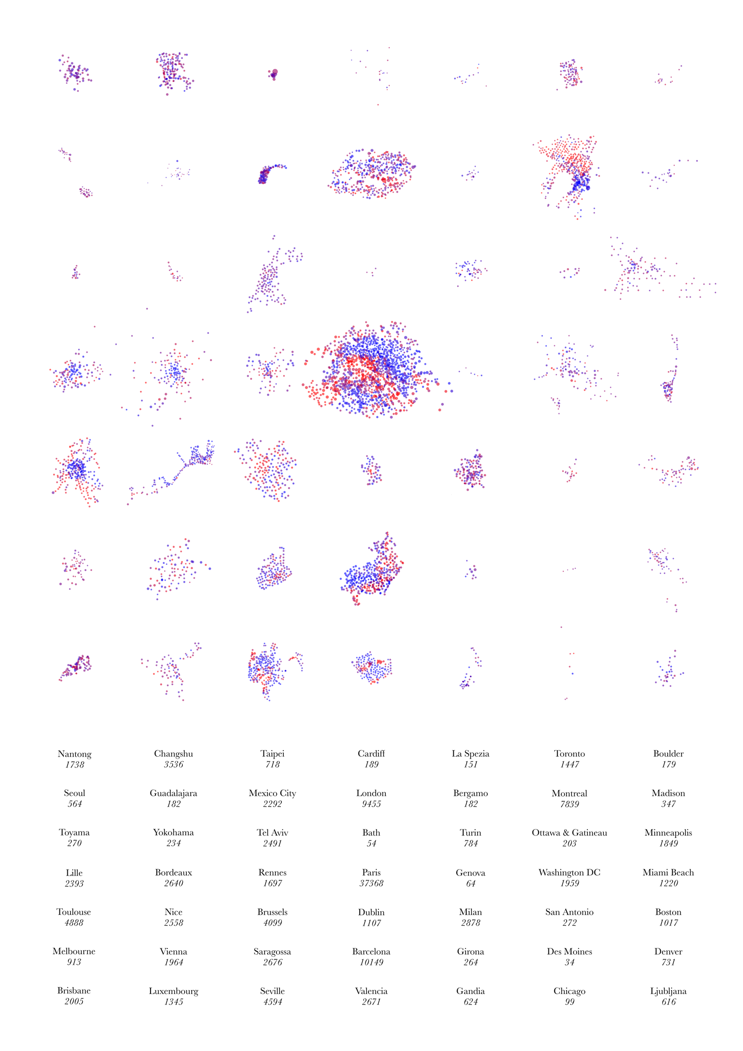
Above is the image I submitted to this year’s UCL Research Images as Art exhibition. You can see it, and around 300 other entries, in the South Cloisters on the UCL campus in central London, for the next few days. The image purposely has no explanatory text as it is intended as a piece of “infogeographic art” rather than as a map. It is derived from the dots for the various cities on my Bike Share Map.

It shows the “footprint” of the docking stations making up 49 bike share systems around the world. The colours represent the empty/full state of each docking station at the particular moment in time when the image was made. The numbers show the total number of docking points – each docking station being made up of one or more docking points, each of which may or may not have a bike currently parked in it.

The geographies and topographies of the cities themselves inform the shape of the systems – particularly coastal cities (e.g. Nice, Rio, Barcelona, Miami Beach) and ones with large lakes mountains near their centres (e.g. Montreal).

A subtle but important point on the scaling: The scales of the systems (i.e. each system footprint and the spacing between docking stations) are roughly comparable – they actually vary by the cosine of the latitude – these means that the more tropical systems, e.g. Mexico City’s, appear to be up to ~20% smaller than they actually are, relative to the majority which are generally at temperate latitudes. However, the sizes of the circles themselves are directly comparable across all the systems, i.e each pixel on the graphic represents an equal number of docking points, regardless of which system it is in.

Categories
Leisure Orienteering Orienteering Events Log

Orienteering Update

My autumn went roughly as planned, in terms of orienteering races, until early December where I got the first in a number of very minor injuries that were nonetheless enough to keep me from running. However I was still able to walk so made it up a number of Munros during a new year trip to the Highlands.

I think I’m almost back to being able to run now, although I have dropped in fitness slightly. Here’s my race plan for Spring 2012:

  • Tue 10 Jan – SLOW Marylebone Street-O
  • Sun 15 Jan – MVOC Holmbush
  • Sat 21 Jan – EUOC Edinburgh City Race
  • Sun 22 Jan – EUOC Holyrood Park
  • Thu 26 Jan – CHIG Victoria Park Street-O
  • Sun 29 Jan – BKO Concorde Chase?
  • Thu 2 Feb – SAX Sevenoaks Street-O
  • Sun 5 Feb – DFOK Chelwood
  • Tue 7 Feb – SLOW Brockley Street-O
  • Sun 12 Feb – CHIG Claybury
  • Sun 19 Feb – CompassSport Cup Qualifier
  • Sun 26 Feb – SLOW Wimbledon
  • Sat 3 Mar – St Andrews Scottish Sprint Champs
  • Sun 4 Mar – St Andrews City Race
  • Sat 10 Mar – Varsity Match at Burnham Beeches
  • Sun 11 Mar – Varsity Match Relays
  • Tue 13 Mar – SLOW Street-O
  • Sun 18 Mar – DFOK Mereworth?
  • Wed 21 Mar – Possible Munro trip
  • Sat 24 Mar – British Sprint Championships, York
  • Sun 25 Mar – British Middle Championships, near York
  • Sun 1 Apr – Waltham Half Marathon
  • W/e 6-9 Apr – JK, Scotland
  • Tue 10 Apr – SLOW Street-O
  • Sun 15 Apr –
  • Sat 21 Apr – JOK Chasing Sprint
  • Sun 22 Apr – Back to London to help at the London Marathon?
  • Sun 29 Apr –
  • Sat 5 May – British Championships, Lake District
  • Sun 6 May – British Relays, Lake District
Categories
Bike Share

Massive Christmas Day for Boris Bikes

Christmas Day this year recorded far and away the highest ever simultaneous usage of the Barclays Cycle Hire bikes, aka the Boris Bikes, probably meaning it was the biggest number of hires in a single day too. The lack of any Christmas Day tube or bus service in the capital is the obvious reason for the huge usage spike. Previous popular days for the were the four tube strikes in late 2010. Both these events can be seen in the graph above. There is a diamond for each day, showing the difference between the maximum number of bikes available at a point in the day (typically at around 3am), and the minimum available (typically around 4pm for weekends or 9am/6pm for weekdays). Christmas Day was the big jump on the far right of the graph. The jump is much bigger than for Christmas Day 2010, as that day was pretty cold and snowy and only especially hardened tourists would be using the bikes then.

The top days are (measured by maximum closed-system simultaneous usage, i.e. maximum number of Boris Bikes out of the docks and rolling around the streets in a single moment, assuming no removal or addition by the operator that day):

  • Sunday 25 December 2011 – 2065 (Christmas Day – no tubes or buses)
  • Sunday 2 October 2011 – 1795 (Late summer heatwave)
  • Thursday 3 February 2011 – 1791 (?)
  • Tuesday 15 March 2011 – 1649 (Likely false result – mass removal)
  • Saturday 1 October 2011 – 1627 (Late summer heatwave)

Actual total usage on each day is likely to be roughly proportional, and typically ~20 times the above numbers.

Note – please don’t read too much into the lowest usage days that appear on the graph. We’ve had quite a few power problems with our server room this year, and such low days may simply be when we were able to record little if any data. Large-scale bike removals and additions by the operator can also distort the results quite a bit, by perhaps up to 500 bikes a day. Mass additions to the system will depress the true result for that day, while mass removals can falsely inflate the numbers. It’s difficult to spot these, except by looking at the graph for the previous and following days, and comparing the max/min numbers.

Categories
Bike Share

Bike Share Map Update – 6 New Cities, Weather, Stats

Now available on the Bike Share Map are five extra French cities: Montpellier, St Etienne, Calais, Valence and Vannes, as well as Kunshan in China. I’m also now showing the relaunched bike share in Rio de Janeiro – yes, you can #bikeshare beside Copacabana Beach. This brings the total currently being visualised to 45 – not including several that have shut down for the winter and will be back, and some others where I’ve been asked not to collect the data. Thanks to Russell from the Bike-sharing Blog for the tip-offs for all of these.

So far, Montpellier, Rio and Kunshan are looking potentially very interesting, while there’s nothing much going on in Calais, St Etienne, Valence or Vannes.

I’ve also added some extra stats on each bike share, showing the number of docks and how many are completely empty and completely full – often surprisingly many after rush-hour for certain cities.

Finally and perhaps most importantly I’m now showing current weather conditions for most of the cities. The data is the METAR information for the major airport nearest each city, supplied and decoded by the NOAA Internet Weather Source. I’m picking up the reports every hour or so (some report less frequently) and caching them. Hopefully they will prove accurate. Currently it’s reporting 0°C in Toronto and 27°C in Rio de Janeiro.