Here’s a mystery building for you – can you guess what it is? It’s in the City of London.
Here’s a mystery building for you – can you guess what it is? It’s in the City of London.
Here is how I am layering the City of London map, which I am creating using Adobe Illustrator and the MapStudio plugin. I’m basing the features/colours on the ISSOM2007 spec, as much as possible.
Layers
| Layer | Main Colours | Features |
|---|---|---|
| O-Courses | Purple, Brown | Courses, Corrections, Northing Lines |
| Tunnel Walls | Black Dots, Brown | Showing runnable routes below main level. May use thick brown lines to show tunnel entry points. |
| Point Features | Black, Green | Statues, Fountains, Ornamental Pillars, Lifts*, Stairwells, Distinctive Trees |
| Buildings | Dark Grey, Black | Buildings |
| Construction | Black, White | Construction Sites and Hoardings |
| Barriers | Black, Dark Green | Uncrossable Barriers (Walls, Gates and Railings), Crossable Fences, Hedges, Historic Stone Walls |
| Low Walls | Light Grey | Crossable Walls |
| Out of Bounds Land | Olive Green | Permanent Out-of-Bounds Open Areas |
| Water | Blue | Lakes, Rivers, Water |
| Steps | Dark Grey | Staircases, Steps |
| Underpasses | Light Grey | Underpasses, Building Canopies |
| Vegetation | Dark Green, Light Green, White | Flowerbeds (OOB), Woods |
| Open Land | Yellow | Accessible grassy areas |
| Pavement | 10% Brown | Pavements, Pavement-level Roads (May be revised to simply be thin lines show significant paved areas separated from the road.) |
| Road | 20% Brown | Roads (Colour may be changed to match the Pavement colour, to aid clarity) |
Line widths
| Linear Feature | Width |
|---|---|
| Steps, pavement edges, underpass boundaries | 0.07mm |
| Out-of-bounds (OOB) boundaries**, crossable fences, building boundaries, prominent boundaries within OOB areas | 0.14mm |
| Underpass dots (dot diameter) | 0.2mm |
| Crossable walls, uncrossable*** barriers (fences/walls), stairwell sides and separators, construction site boundaries | 0.35mm |
*These will probably be removed from the map in a later revision. You can’t really use one competitively!
**In some cases, no line is used (e.g. driveway) or the wall-line is used (obvious wall blocking use of OOB area as a run-thru.)
***Crossable underneath the barrier if dotted lines indicate a passageway underneath the main running level.
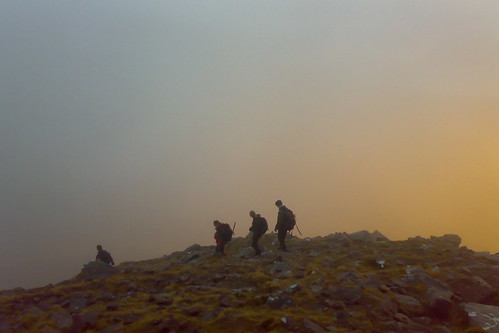
Well I never thought I would be orienteering in true Eastenders country, but CHIG (Chigwell & Epping Forest OC) launched their new permanent orienteering course at Beckton District Park last Saturday with a score event, held in conjunction with Newham Fit Club – a collaboration between the borough council and the local NHS trust. This must be the best value orienteering event I’ve ever been to – free, with free map & pencil, free water at the end, a free goodie bag with “runner’s” water bottle, free medal and certificate of completion, and, apparently, for earlier runners – a free T-shirt. The only other event with this kind of value is the Bushy Park Time Trial (and the other UKTT events.)
The event was a one hour score around all 23 of the permanent markers. I ran around in 21 minutes, covering 4.3km according to my GPS. I thought it was a good time, but a couple of others also clocked 21 minutes, so I ended up first equal. Results here and my writeup here.
The area is never going to compete with CHIG’s prime area, Epping Forest, but it’s a nice enough little park, the area around the pond is probably very pleasant on a hot summer’s day, although the A13 thunders by just to the north.
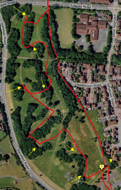
The interesting middle section of the course. Yellow arrows show locations of the permanent control posts. My later long run back to the north part of the map for the final controls, is also shown.
My GPS curiously recorded about half my run as being under sea-level. While the park is certainly only a few metres above the Thames Estuary, it isn’t flooded yet. GPS altitude calculations are so inaccurate…
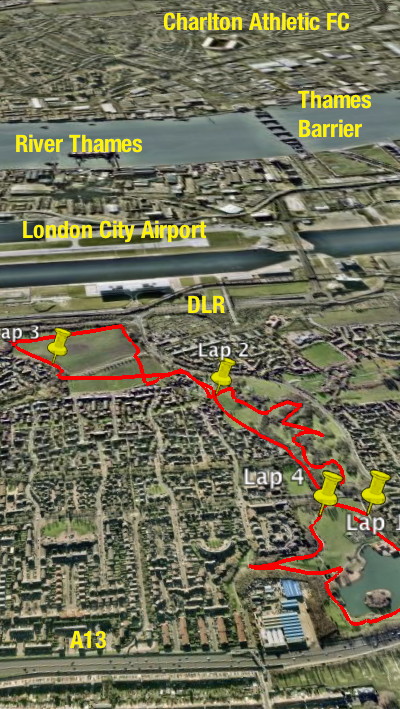
The park in relation to the Thames and other major landmarks in the area.
Beckon District park is my nearest “active” orienteering area – it’s a short cycle away along the Greenway. Victoria Park is closer, but there hasn’t been an event there for many years, due to, I think permissions problems. I would love to approach Tower Hamlets borough council and suggest a similar kind of collaboration with my club SLOW for “Vicky Park” although it would be a lot of work to put the pieces together and the map would need quite an update – and it’s an LOK rather than a SLOW map anyway.
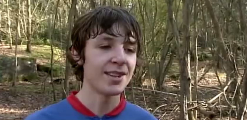
There was a feature on orienteering on the news this morning – I screengrabbed it, take a look:
https://www.youtube.com/watch?v=LUBvD-vgZbM
More GPS tracklogs overlaid on high-resolution aerial photographs in Ascent:

1. The Bushy Park Time Trial (5K) route – now going clockwise around the park.

2. A quick (700m) warm-down jog up and down one of the tree-lined terraces in Bushy Park. Notice you can see every tree.

3. Today’s exhausting orienteering race at Woolbeding Common – M21L. Quoted distance was 11.9km, but, per my GPS, I actually ran at least 14.5km.

4. A mistake on the Woolbeding Common race – at number 18 – approaching from the left. It was just after the 12km mark and I was tiring badly, so my concentration went. I swung away from the control too early, and strayed too close to the distinct vegetation change. I only found the control “by luck”, while starting to relocate back onto a path.

5. Finally, from Google Earth, a view of my steep descent from near the summit of Arthur’s Seat in Holyrood Park, Edinburgh, during my orienteering race there last summer.
Saturdays am – Bushy Park Time Trial 5K
Saturdays pm – City of London map fieldwork
26 Jan – EUOC Edinburgh City Race
27 Jan – EUOC District, Holyrood Park
3 Feb – GO “OO Trophyâ€? Regional, Woolbeding Common
10 Feb – TVOC “Chiltern Challengeâ€? Regional, Downley
12 Feb pm – SLOW Street-O, Notting Hill
17 Feb – SO District, Clapham Wood?
21 Feb pm – LOK Street-O, Hampstead
23 Feb – CHIG Local, Beckton Park
24 Feb – LOK Regional, Holmbury
2 Mar – SAX Regional, Mill Bank & Whiteley
9 Mar – SARUM National, Great Ridge?
11 Mar pm – SLOW Street-O, Putney
16 Mar – CHIG District, Epping NW OR BUSA Sheffield
21-24 Mar – JK, Surrey
25-30 Mar – Varsity Match, Sweden
5 Apr – British Elite Middle-Distance Championships, Tamworth?
6 Apr – British Sprint Championships, Warwick
8 Apr pm – SLOW Street-O, Lambeth
13 Apr – (Nothing planned yet)
17 Apr pm – LOK Hyde Park Score
19-20 Apr – British Championships, Culbin
25 Apr-1 May – Course fieldtrip, Lake District
I had an unusual Hogmanay this year – up in Torridon with JOK. We stayed in Kinlochewe, by Loch Maree, and celebrated New Year itself at the Kinlochewe Hotel.
It turns out that quite a few JOKers are closet Munro-baggers. It was great to get out on the hills and climb some Munros, my first multi-day Munroing trip for nine years, I think. I climbed six new Munros, and also climbed Beinn Alligin again – this time, it was misty on the ridge, but still an exciting walk. I decided not to accompany some of the more dedicated Munroists on one of the days, when they climbed five of the Fannichs – not a bad round for midwinter. We didn’t have much in the way of snow, apart from on the way back on the last day.
I definitely need to get back and starting climbing Munros on a regular basis again. Why? Because “they are there.”
Photos from the trip – mostly taken with my cameraphone.
Day reports for the week – on my Attackpoint training journal.
I’m currently building a website that maps my climbed Munros, I will post about it in due course. I hope to eventually make it usable by anyone for tracking their Munro climbing.
Here’s some pseudo-3D geovisualisation of some of the routes we took. The pictures are screenshots from Google Earth, with my route shown in red, having been recorded with my Garmin Forerunner 305 GPS receiver. Not entirely coincidently, I spent Christmas evaluating a dissertation, an assessed part of my MSc course. The topic – Use of 3D geovisualisation to plan hiking routes. It was written before the days of Google Earth, so was quite prescient.
Beinn Alligin: December 31st

Our horseshoe route.

Our steep route down from the first Munro.<br /
Moruisg: January 2nd

Our route around Moruisg and the neighbouring Munro.

Looking along the ridge from the first summit.
Beinn Tarsuinn: January 3rd

Our route, looking from the A9 towards the summit.

View from above the summit, looking back along the approach route.
Here’s a Christmas present – a peak at a partially completed small section of the City of London map. Scale: 1:625 at if viewed on a 72dpi screen.
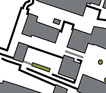
What’s shown: Buildings, passable and impassable walls/fences, and flower beds.
What’s not shown: Roads & pavement boundaries, underpasses, out of bounds areas, steps*. A couple of short walls are also missing.
* I hate drawing steps. Really, they are the most tedious part of creating orienteering maps. So, generally, they are the last thing I draw when doing the cartography.
Google has added Terrain Maps – physical maps with relief shading based on a DEM (Digital Elevation Model) – to the Google Maps API, and they look beautiful. I’ve set them as the default map displayed on my Fixtures Map, because they are clear and uncluttered, while at the same time giving a good indication of the hilliness and terrain type of a particular area.
I also took the opportunity to upgrade the Fixtures Map to version 2 of the Google Maps API. According to Google, this offers a “much smaller JavaScript download” and “two additional satellite zoom levels”, amongst other things.
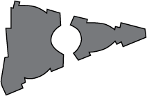
Here’s a building – actually two, the main one is on the left – as seen on an orienteering map. Dark grey = building, Light grey = canopy.
Hint 1: In the City of London.
Hint 2: Very tall building.
Hint 3: Very new.
Hint 4: Very cool.
Hint 5: Overlooking a cartographer’s nightmare.
What building is it?
