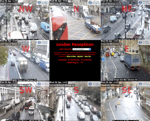
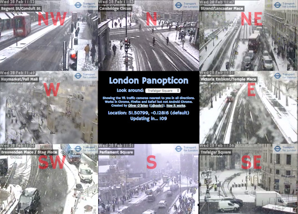
The London Panopticon utilises the traffic camera feed from the TfL API, which recently (announcement here) added ~6-second-long video clips from the traffic cameras on TfL “red route” main roads, to show the current state of traffic near you. The site loads the latest videos from the nearest camera in each compass direction to you. The images are nearly-live – generally they are up-to-date to within 10-15 minutes. If the camera is “in use” (e.g. being panned/zoomed or otherwise operated by an official to temporarily reprogramme the traffic lights, see an incident etc) then it will blank out. The site is basically just JavaScript, when you view it, your browser is loading the videos directly from TfL’s Amazon cloud-based repository.
The Panopticon continuously loops the video clips, and updates with the latest feed from the cameras every two minutes, the same frequency as the underlying source. If you are not in London or not sharing your location, it will default to Trafalgar Square. I’ve added a special “Blackfriars” one which is where the under-construction Cycle Superhighway North/South and East/West routes converge – during rush hour you can already see bursts of cyclists using the new lanes.
Try it at vis.oobrien.com/panopticon and note that it only works on desktop web browsers (I’ve tested it on Chrome, Firefox and Safari). It didn’t work on Internet Explorer “Edge” when I tested it on a PC. It also does not work on Chrome on Android and by extension probably mobile in general. It possibly uses a lot of bandwidth, so this is perhaps just as well.
I’ve named it after the Panopticon, a concept postulated by Jeremy Bentham, co-founder of University College London, where I work, in the 1800s for easy management of prisons. The Panopticon encourages good behavior, because you can’t see the watcher, so you never know if you are being watched. Kind of like the traffic cameras.
The concept evolved from a special “cameras” version (no longer working) of the London Periodic Table, which was itself a follow-on from CityDashboard, both of which I created at CASA. The source is on GitHub.
p.s. If you made it this far, you might be interested in a hidden feature, where you can specify a custom location. Just add ?lat=X&lon=Y to the URL, where the X/Y is your desired latitude/longitude respectively, in decimal coordinates. Example: http://vis.oobrien.com/panopticon/?lat=51.5&lon=0.
2 replies on “London Panopticon”
Very cool – might it be worth excluding any cameras where availability is false?
[…] 1: London Panopticon [Near live London traffic cameras] Link 2: London Panopticon | Suprageography The London Panopticon utilises the traffic camera feed from the TfL API, which recently added […]