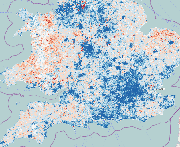
Dr Muki Haklay, UCL CEGE, has been carrying out some quantitative research into OpenStreetMap’s coverage in the UK, comparing road lengths in each square kilometre, with those in a definitive national dataset, Ordnance Survey Meridian 2. He’s updated his findings every few months, from March 2008 until March this year. Some interesting research findings have been found, such as a potential correlation between an area’s affluence and the map’s completeness, a possible reflection of a contributor demographic. On his suggestion I’ve taken his dataset and overlaid the red/blue under/overcompleteness maps on OpenStreetMap (or Ordnance Survey StreetView) itself, allowing the specific towns and villages that are missing the OSM love, to be identified.
The mashup can be viewed here [no longer online].
These days, OpenStreetMap’s coverage is pretty good -often exceeding Meridian’s, as service roads, private roads and alleys, that don’t exist on Meridian 2 are added in. There’s still (as of March 2011) some significant holes though, particularly in parts of Wales, the North East and East Anglia.
Note the first four maps only cover England. There is an interesting artefact in the first one – a square around London can clearly be seen, corresponding to the extent of aerial imagery, in that area, that was available via a special agreement with Yahoo for tracing. Outside of that area, only 50-year-old (out of copyright) maps and contributor GPS traces were available. Since May last year, the Ordnance Survey OpenData release, and Microsoft Bing Aerial imagery, which became available at roughly the same time, has significantly accelerated work on the map. I presented on the diverse sources of data at the Society of Cartographers annual conference last year, you can see the slides here.
ITO World’s OS Locator is just one of a number of tools that the OpenStreetMap contributor community in the UK is using to “complete” the map, moving towards the goal of a comprehensive free database of the UK’s (and world’s) streets.