I’m just back from six days of top quality orienteering races in Moray, north-east Scotland. As ever, the days were very varied, with three days of forested dunes, two hilly inland map, and one flat (but still intricate) forest that I once trained in when in the Army section of the CCF at school! The Scottish weather also lived up to its four-seasons-in-a-day reputation, with two days of pouring rain, two days of bright sunshine, and everything in between. I was running M21L, as I didn’t think I would make it around the M21E 17km+ classic on Day 6, and because I was aiming for the top half of the results table each day, rather than inevitably hanging around the bottom 20% as would happen on the Elite class.
Day 1 was at Lossie forest, a classic sand-dune area which I didn’t have great memories of – mainly because I was smaller when I last ran it and I remember the sand dunes being steep and dense – walking rather than running required in order to avoid getting quickly lost. Sadly, it is not quite the same as it was these days – a new track running right through the intricate part meant that the technical level has greatly dropped, and the course design (perhaps necessitated by the sheer number of people, around 3500, at the Scottish 6 Days event) meant that many of the legs were a procession between controls, with people and/or tracked routes pointing the way between controls.
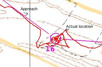
I had a very poor start, heading off 90 degrees in the wrong direction (following the train…) and later on I made my biggest mistake on this day, although this was primarily due to a control being placed on a feature mapped in the wrong location on the map. Discussion afterwards indicated that plenty of others also were delayed here, but unfortunately I responded particularly poorly to the map’s mistake, looking for an (absent) flag rather than the misplaced feature, which was fairly easy to see, if 80 metres NE of where it should have been:

Day 2 was the aformentioned Army area – Carse of Arsidier. I had a cleaner run here, with just the few small mistakes which were a hallmark throughout the week of me not staying in enough contact with the map as I should be. Day 3 was back onto dunes, at Culbin, although it was the western part of the map rather than the more familiar main section which we visited during the following rest day for a Trail-O. Day 3’s result was my worst of the week, although I think this was primarily due to having an early run on that day, with little tracking to follow. There is a presumed correlation between the time people run on a large forested (i.e. trackable) event and how well they do. Day 4 was the first hilly day, at Loch of Boath. Unfortunately it was also the wettest day. It was also potentially my best day, with a pretty clean run, until near the end when I started to think “I’m on for a good one here” and promptly made two medium-sized mistakes in a row.
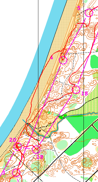
Day 5 was back to the dune areas and Roseisle. This was always going to be my favourite area of the week and so it proved, with undergrowth-free pine forest (with a lovely natural pine smell in places!) providing just enough technicality to slow down the sprinters. I took three legs on the beach, just because I could, rather than because it was the best route – the problem here though was that it was difficult to spot when to go back into the forest. I overran the first beach leg (3-4) and underran the second (4-5):

More to follow in the next post on Day 6 and the Trail-O.
One reply on “The Scottish 6 Days at Moray”
[…] final day of Moray 2013 looked, on paper, quite similar to the others – around 9km, like the previous 5 days. However it was quite different in feel, with the […]