Categories
Data Graphics London

A Periodic Table for London

Here is a webpage that uses my own CityDashboard API*, to build a Periodic-Table inspired “data artwork” of live London information, as a series of coloured square panels on a website. The squares update regularly with fresh information, and throb red (or blue) if there are particularly extreme values present.

As an artwork, it’s deliberately not 100% clear what it shows. A key on the bottom right will help a bit, but a degree of guesswork will be needed for some of the panels. With a bit of thought, almost all of the panels should be decipherable.

It’s a super-simple webpage. I’m using CSS3 for the animations – no Javascript used. The page is customised to be most relevant to the CASA office here in central London – the chosen weather station, bike share stands, air quality monitor and variable message road sign have been chosen accordingly. A more sophisticated version – which doesn’t currently exist but would be simple to do – would use a combination of the location information in the CityDashboard feeds, and the HTML5 geolocation functionality of many browsers, to show a version more relevant to where in London the viewer is.

As the page is so simple, it displays well on mobile browsers – on my iPhone, the webpage shows four panels on each row. On larger displays, it will rearrange appropriately. See the acknowledgements link on the page to see where the data’s coming from – the same sources as CityDashboard, including TfL, DEFRA, Yahoo! Finance and Mappiness, as well as CASA’s own sensors.

I created the piece for the ODI’s recent Data as Art installation competition – I didn’t win, but decided to do it anyway.

Live version here.

*Strictly, I’m using my Bike Share Map data for the individual docking station information – this could be easily added to the CityDashboard API in due course.

Categories
Data Graphics London Mashups

Update to CityDashboard CSV API & iPad Wall!

I’ve made some minor alterations to the CSV API for CityDashboard. The main changes are in the metadata rows (the top two) rather than the subsequent rows. Specifically, the top metadata row has now split out the description, source and source URL – which were previously rather messily combined into a bit of HTML – into three text fields; and the second metadata row now uses properly formatted names for value titles, i.e. including spaces, and units, for example “broken_pc” now becomes “% docks/bikes broken”.

The reason for these changes is to accommodate a new and exciting use of the API here at CASA – our lab hardware specialist has recently been hard at work building an “iPad wall” and one of the visualisations in it is of CityDashboard data. Here’s what the uncompleted – but operational – iPad wall looks like (source):

It’s a physical CityDashboard!

I also took the opportunity to fix a few bugs and typos – mainly just cosmetic, but including a pretty silly one for the Mappiness-sourced data that was over-reporting the true value by a large and variable amount. Entirely my fault. That will serve me right for doing a coding change during a colleague’s Ph.D viva drinks reception! I also handle temporarily unavailable source feeds a little better – they’ll now appear unavailable for one complete update cycle but it means the source server doesn’t get repeatedly hammered until it comes back up again.

Categories
Data Graphics London

The Electric Tube

[Update – An updated version of this is currently available as a limited edition A2 print.]

In six weeks time, London will have a second orbital railway. The Circle Line has been running for just over 100 years, and on 9 December will be joined by the latest addition to Transport for London (TfL)’s Overground network – a link between Clapham Junction in the south-west and Surrey Quays in the south-east. This means that the West London Line, North London Line, East London Line and South London Line will all be linked up (you won’t be able to travel 360 degrees on one train though – you’ll need to change at both Highbury & Islington and Clapham Junction, and often Willesden Junction, to complete a circuit). Should you travel around the complete loop, you’ll pass through areas as varied as Imperial Wharf, Dalston Junction, Whitechapel and Peckham Rye.

Anyway this was a tenuous excuse for me to produce a diagram – above – of London’s TfL-owned network – the Underground, the Overground, the DLR, Tramlink and the Cable Car. Click the graphic for a larger version. My starting principles for the diagram were concentric circles for the orbital sections of the Circle Line and the Overground network, and straight lines for the Central and Piccadilly Lines, with the latter two converging in the centre of the circles. I then squeezed everything else in. I realised that the Northern Line’s Bank branch passed the Circle Line three times so was going to need something special, so I added a sine wave for this section, and extended this north and south as much as possible.

The River Thames is on there – because any tube diagram doesn’t look correct without the river – and the diagram is topologically accurate – everything connects correctly, and features are in an approximately correct geographical position relative to their neighbours, but not to the diagram overall. Only stations that are designated intersections, or have connections with National Rail stations, are shown. I haven’t labelled anything. It’s art.

I was also thinking about physics when creating the diagram – specifically Feynman diagrams, bubble chamber traces, particle physics collisions, magnetic flow lines and electrical circuit diagrams (as was Beck himself). Hence why I’ve called it the Electric Tube.

The work was also inspired by the likes of Fransicso Dans (more) and Project Mapping, as well as of course the famous Official Tube Map. [Update – I’ve updated the map slightly to add in Tramlink and a few more connections.]

Categories
Orienteering

Urban Events – How Far Do People Travel?

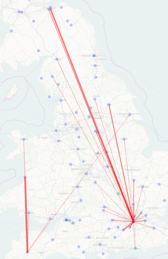
Intrigued by a comment on the Nopesport forums suggesting that local clashes rather than a very major international clash were the thinking behind the scheduling of a future urban event, I thought I would do some analysis of how far people travel to races, using my stats database of results.

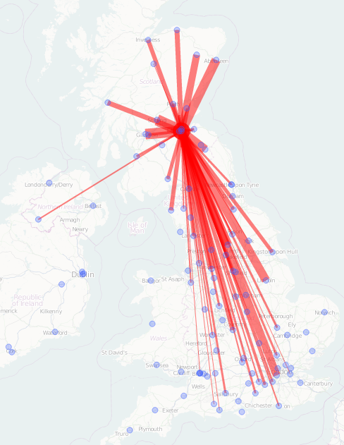
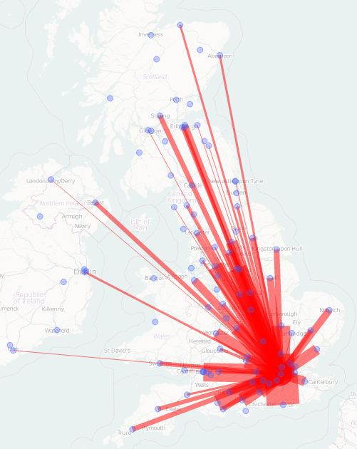
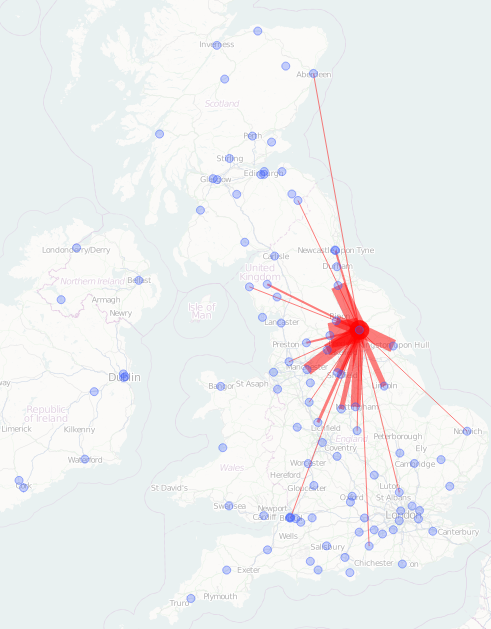
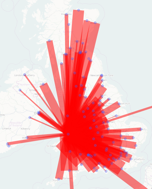
To do this, I’ve excluded (a) people listed with a club of “IND”, “None” or “” (probably local non-orienteers), (b) people in non-geographical clubs (e.g. RAFO, AROS), as it’s difficult to pinpoint where they travelled from, and (c) clubs with less than 100 runs in the 3 or so years the events database runs back for – this leaves 113 clubs, the largest being BOK with 8534 runs. The latter exclusion also excludes most foreign clubs, although a number do make it through – particularly Irish ones. I’ve also assumed that remaining people live in the centroid of their club’s area of influence – which is “guesstimated” by me based on the name of the club. I’ve also assumed that the event, put on by the club, also takes place in the centroid of that club’s area of influence.

Anyway, here’s where everyone* travelled from to get to the Edinburgh City Race in January 2012:

…and for comparison, here’s where people came from to go to the London City Race in September 2012:

…and York’s City Race in June 2012:

…and everyone (& their dog) went to Aberystwyth in July 2012 for the biggest urban race ever in the UK:

None of these maps are normalised to each other – thickness directly corresponds to the number of people.

Tobler’s Law in full effect for these races, of course, but also showing a decent amount of long distance travel to London and Edinburgh. For Aberystwyth, everyone was already there for the rest of the Welsh 6 Days event.

Finally, for a bit of fun, here are the events that I (and also my namesake in Devon!) have been to in the last three or so years:

* Bearing in mind the filters outlined at the top of the post.

Background imagery courtesy of OpenStreetMap contributors.

Categories
Mashups

Boundary Change Map

I pulled together an interactive map of “Proposed Constituency Boundary Changes” in England, after the information was released by the Boundary Commission for England last week. My colleague James Cheshire highlighted that this kind of map could be illuminating, particularly as the official maps are simple greyscale PDFs of each new constituency boundary, without the old boundaries or adjoining constituencies for context, and with one document per constituency!

Click the image above to go to the interactive map, then use the slider to fade between the current and proposed boundaries. [The map is no longer online, as the boundary change didn’t go ahead.] The new boundaries have been put together to have roughly the same populations in each one (72000-80000 people), and also the total number of constituencies has been dropped by around 5-10%. They are just proposed ones, and are themselves revised from an earlier version.

There are some interesting patterns – many urban areas, such as London, have undergone very significant redrawings, while many rural areas – historically with higher constituency populations – remain untouched. For example, Tottenham loses its identity as a single constituency, the southern half being assimulated into Stamford Hill and the northern half into Edmonton. Slough has a big bite taken out of its SW corner, the people here potentially being represented by a Windsor MP in the future. Much of north Yorkshire is unchanged however.

We didn’t use vector-based boundaries here, even though this would have made it more interactive, because of the size of the boundary files – simplifying them to reduce the size would have been tricky (as it would have made unmoved boundaries move slightly) and the necessary simplification might have distorted the boundaries too much.

As with all my more recent web visualisations, social media (Twitter and Facebook) buttons are included, and geolocation is used to default the view to the user’s location, if they are in England.

On a technical note, this is my first pure HTML5 map. It also takes advantage of simpler ways of setting up maps in the latest release of OpenLayers, 2.12. It means it is out-of-the-box compatible with mobile browsers, and the HTML, JavaScript (including a JQueryUI slider) and CSS adds up to less than 200 lines of code – the only other code used being a couple of Mapnik XML stylesheets for rendering the two maps themselves.

Thanks to James Cheshire for the idea and getting hold of the data.

Categories
Data Graphics London

Prism: A Real-life CityDashboard

I was at the V&A earlier today to see Prism, a new installation by digital artist Keiichi Matsuda which is part of the London Design Festival.

Prism uses data from UCL CASA’s CityDashboard and other London open data sources, to visualise London in a novel way. The exhibit, which consists of triangular sails joined together in an irregular pattern, and lit from within, slowly pulses and evolves as the data that the patterns and colours are showing, changes. The visualisations are derived from fast-changing weather, travel and other London data sources. There is no key at all so you have to use your imagination to hypothesise what each panel is showing – although a couple have TfL roundels and bike share bikes on them, hinting at their purpose. Prism’s shape and positioning makes it look slightly organic, as it appears to about to burst through the floor and into the gallery space below.

Seeing Prism is a bit of a mission – it requires first going to the sixth floor of the V&A – not immediately obvious to find – then signing a disclaimer, ascending – in small groups of just 6 – a tiny spiral staircase. You then move across a narrow ledge, before finally you enter the darkened room. Prism is suspended in the middle, allowing a 360-degree inspection, and also a glimpse of the galleries beneath. Another spiral staircase, in one corner, then allows visitors to get a different, surprise view.

If you want to see Prism you need to book a timed ticket (free) in advance, and be aware it’s only on for the next 10 days. If you don’t manage to get a ticket, you can still see a glimpse of the base of Prism, as it is suspended over one of the galleries on the sixth floor of the museum.

Categories
Conferences

Behind the Scenes at the British Library Map Room

I was lucky enough to be on a private tour of the British Library Map Room, as part of the Society of Cartographers conference at the beginning of the month.

The tour showed some of the treasures of the Map Room, including the world’s first printed colour map, proofs of the world’s largest atlas, and a fragile nested set of globes; followed by a walk through the huge, industrial map storage facility in the bottom basement underneath the British Library (the Northern Line could be heard rumbling above!) and a quick look in the Map Reading Room. Some of the older maps of (real) places look like they are straight out of a fantasy novel – presumably the latter being heavily influenced by the former. A good example is above.

Thanks to the SoC for organising and the Curator of Antiquities for showing us around.

Categories
Conferences London

Mapping London Presentation for the Society of Cartographers Conference

I presented on the Mapping London blog, at the Society of Cartographers’ 48th Annual Conference which was at UCL this year, showing a general outline of the blogs and some maps featured on it, plus some work done by James and I. My presentation is here (6MB PDF). Note that the attribution for the many maps featured on the presentation is at the end.

Categories
Data Graphics Technical

CityDashboard Weather Forecasts – Yahoo! to the Rescue

After Google abruptly turned off their XML weather feed this week, I’ve switched to using Yahoo! Weather (an RSS feed) for the CityDashboard weather forecast module. Yahoo uses WOEIDs rather than city names, which takes a bit longer to configure but is unambiguous – Google just used the city name, so required careful specification to get Birmingham (UK) weather rather than Birmingham (Alabama, US) weather, for example. Google’s feed was undocumented (so, strictly, private) but was widely used on other websites.

I’m using the weather icons (which link to the codes supplied by Yahoo) from the WeatherIcon project.

It works well. Thank you Yahoo!

Maybe Yahoo! is about to become the new Google?

Categories
Bike Share

Bike Share Operators and Social Media – User Engagement with Twitter

Many of the bike share operators whose systems I’ve mapped have accounts on Twitter – but do they use them to reply to customers, notify of system changes, or just tweet promotional measures? Have they built up an appropriately large set of followers? Do they tweet often? An active Twitter account is good customer service, one that replies to queries is great customer service! (N.B. Google has translated the Velib conversation above from French.)

There are 24 operators, for which I able to find a relevant Twitter account. The following table shows how they use it. This does of course leave several hundred other operators (many very small) for whom I could not find an account.

City System Name Size (Bikes) Twitter Account Foll-owers Repl-ies Bad News Score
Mexico City Ecobici 1100 @ecobici 21475 Yes Yes *****
Miami Beach DecoBike 540 @DecoBike 10321^ Yes No ****
London Barclays Cycle Hire 6300 @BarclaysCycle 6673 No Yes ***
Washington DC/Arlington Capital Bikeshare 1400 @bikeshare 5374 Yes Yes *****
Denver B-Cycle 400 @Denver_Bcycle 4652 No Yes ***
Minneapolis Nice Ride 1230 @niceridemn 4100 Yes Yes *****
Paris Velib 15700 @Velib_Paris 3094 Yes Yes ****
Boston Hubway 700 @hubway 3741 Yes Yes *****
Montreal BIXI 4300 @BIXImontreal 3214 Yes Yes ****
Toronto BIXI 820 @BIXItoronto 2801 Yes Yes ****
Barcelona Bicing 3800 @bicing 2358 Yes Yes ****
Boulder B-Cycle 120 @Boulder_Bcycle 1541 Yes Yes *****
Lille V’Lille 1550 @transpole_actu 1322^^ Yes Yes ***
Bordeaux VCub 1300 @tbc 1118^^ No No *
Melbourne Melbourne Bike Share 550 @MelbBikeShare 1095 No No ***
Chattanooga Bike Chattanooga 230 @BikeChattanooga 672 Yes No ****
Kansas City B-Cycle 80 @BikeShareKC 608 No Yes ****
Broward County B-Cycle 150 @browardbcycle 498 Yes No ****
Rennes Le Velo Star 630 @levelostar 384 Yes Yes ***
San Antonio B-Cycle 200 @SA_Bcycle 323 No Yes ****
Madison B-Cycle 220 @Madison_Bcycle 319 No Yes ****
Tel-Aviv Tel-o-fun 860 @tel_o_fun 226 Yes Yes ***
Brussels Villo 3100 @Villo_brussels 152 No Yes **
Ottawa Capitale 230 @capitalbixi 145 Yes Yes ***

^ = Account also handles smaller bike share systems in other cities.
^^ = Account also handles other public transport in the city.

Operators get a star for being on Twitter, another for having more followers than bikes on the street, another for replying directly to at least some user queries on Twitter, another for tweeting and least some system issues and other “bad news”, and another for having made at least a couple of tweets in the last 48 hours.

Large (500+ bike) systems with no active official Twitter account that appear on bikes.oobrien.com: Brisbane, Luxembourg City, Lyon, Milan, Nice, Saragossa, Valencia and Vienna. Not including Chinese or South Korea systems as Twitter appears to not be widely adopted in these countries, at least in terms of official transport accounts. Metrics were measured on 21 August 2012.