Categories
Notes Orienteering

Orienteering, Inspired by London 2012?

Orienteering is not an Olympic sport, it is however a grassroots activity which just happens to have a number of venues (some existing, some potential) close to the site of the 2012 London Olympics. As such, the sport of orienteering could benefit from any increase in interest in sports in this part of east London, caused by the approaching Games.
london2012orienteering

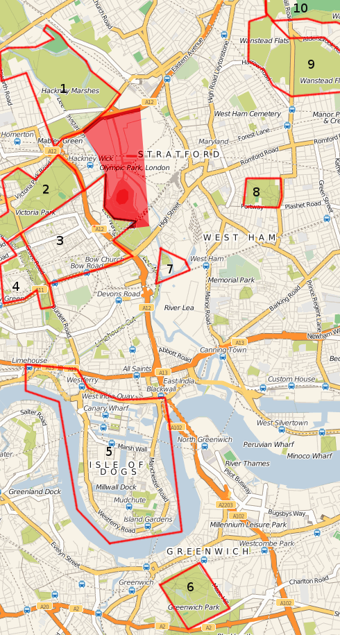
The above map (basemap by Cloudmade, based on OpenStreetMap data) shows existing and possible venues for orienteering events around the Olympic Park site which is shaded in red:

  1. Hackney Marshes and Mabley Green. A very large (400 acre) venue, although not particularly interesting – essentially football pitches as far as the eye can see. However, there is enough of interest for a local event, particularly if the two parks on the west side of the Lee Navigation are included. A hidden gem just in the south part is Wick Woodland, a proper, dense wood with a maze of paths. Sadly, the Waterworks Nature Reserve, just to the north of the marked area, is likely to be out-of-bounds. I believe LOK have an old black-and-white map of the main part of the marshes, from the eighties. The East Marsh is due to be tarmacked over and turned into a giant car park for the Games themselves.
  2. Victoria Park is another large (200 acre) green area, LOK mapped it many years ago and it was used quite regularly for events, up to around 10 years ago. I understand they are about to re-map it and it will hopefully be used for an event next summer.
  3. Bow – this area was first used for a Street-O race in Septemberevent results.
  4. Queen Mary and Mile End Park was used for a SLOW park race in 2008. The campus area is small but allows for exciting sprint racing, the park is also narrow but has some interesting features. A new bridge across the Regent’s Canal has just opened, which will allow the map to be expanded for a similar race in the future.
  5. The Isle of Dogs including Canary Wharf and Limehouse – this is an aspiration, no orienteering map exists yet, and organising a race here would be a huge logistical challenge, but this would make a super area for a city race, possibly in 2011 or 2012.
  6. Greenwich Park – DFOK have created an orienteering map of this hilly 180 acre royal park, which is also a venue for the 2012 Olympics. It was used for an event in March, and there will be another one in April 2010.
  7. Lea River Park – at the moment, the useable area – Three Mills Green and the House Mill – is possibly too small even for the smallest event, and there is no existing map. However, the surrounding area is due to be developed into various new parks over the next six years, so a map of this area could grow with the developments.
  8. West Ham Park – quite small (80 acres), but pleasant, could probably sustain a small summer park race. Not yet mapped for orienteering.
  9. Wanstead Flats – a large, but very flat and simple area, unfortunately split up into three sections by two busy roads. Already mapped by CHIG.
  10. Wanstead Park – a ruined, historic estate, very dense vegetation in places, but used by CHIG fairly regularly for summer events – would possibly be more suited for winter events due to the extent of the vegetation growth!

Also:

  • Regent’s Park (LOK) – not on the map here. Newly mapped by LOK, they are keen to stage an event in this royal park which will also be a venue for the London Olympics.
  • The Olympic Park itself. Much of it will become available to the public, and therefore potentially for orienteering, in summer 2013.

No orienteering club is based in the East End – indeed, London’s four orienteering clubs sort of converge on this point. London OK (LOK) is based around Hampstead and is generally active in London’s north-west quadrant. Chigwell OC (CHIG) is based around Epping Forest in the north-east. Dartford OK (DFOK) generally runs events in the south-east of the capital. Finally, South London OW (SLOW) is mainly based in the south-west, around Wimbledon and Kingston. There are a couple of SLOW maps in the East End – but only because I live there and have created them!

This means that a collaboration between the four clubs would make sense, for any London 2012-themed series planned for the future.

Categories
Notes

Trail Challenge

(10534)

Last Tuesday was the first Trail Challenge of 2008, organised by SLOW, in Bushy Park, one of London’s Royal Parks. I volunteered to be course planner, to get some planning and organisational experience ahead of a couple of races I will hopefully be putting on later this year. This meant I didn’t get to run, as I was out putting out controls and guarding them. However, it was a good opportunity to take some photographs on what was another warm and pleasant summer’s evening.

As is traditional for the Bushy Park race, the route included an (optional) water splash, which I was surprised to see most (~70%) of competitors taking – as it was early in the race, and not that shallow!

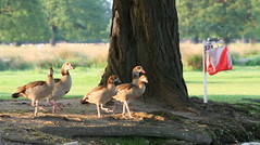
Time to Reclaim the Control (10446)The first control was also quite a spectator friendly one – beside the Duck Pond. The local residents (i.e. the aforementioned ducks) weren’t too happy with the crowd of runners suddenly appearing, and noisily reclaimed their spot once the racers had moved on. The park was, as usual, brimming with wildlife, with several large herds of deer providing an unmarked obstacle. I also spotted a few regal swans and a large heron.

More details about the race – you can also see the routes I planned from here.

Categories
Notes

Spring

Oops, I forgot that my Twitter account posted all my updates on this blog – hence all the recent posts aren’t very substantive.

Just a quick update on the City of London orienteering map work. Here’s the progress so far:

View Larger Map

The grey areas are the remaining bits, I’m hoping to get them done in June. Green are the nicest areas, red the worst.

Here’s the events I’m hoping to do soon:
13 May pm – SLOW Trail Challenge at Bushy Park (planning)
17 May – JOK Chasing Sprint at Bloom Wood (helping+running)
20 May pm – TVOC Summer Series at Park Wood
26 May – EBOR Park Race at York
5 June pm – LOK Local at Hampstead Heath
7 June – WRE Sprint at Shrewsbury
8 June – HOC National at Brown Clee
10 June pm – TVOC Summer Series at Wittenham Clumps

As always, my map of forthcoming orienteering events is an invaluable planning tool!

Categories
Notes

b28


Photograph by Bossanostra.

Categories
Notes

OSM London Summer Mapping Marathon

Just noticed that there’s going to be a series of mini-mapping parties on summer evenings, around central London – the roads are traced, so it’s all about adding street names and POIs (Points of Interest.)

Details.

I can’t make the first one but am going to try and be at some of the others.

Maybe, by the time Autumn comes around, I’ll be able to generate maps for the SLOW 2008-9 street-O series, off OSM, rather than off Ordnance Survey maps as is (I think) currently done.

SLOW Street-O map segment:

Corresponding area in OpenStreetMap:

Categories
Notes

Mystery Building

Here’s a mystery building for you – can you guess what it is? It’s in the City of London.

Mystery City of London building

Categories
Notes

Orienteering on the News

There was a feature on orienteering on the news this morning – I screengrabbed it, take a look:

https://www.youtube.com/watch?v=LUBvD-vgZbM

Categories
Notes

Google Maps API – Terrain Maps

Google has added Terrain Maps – physical maps with relief shading based on a DEM (Digital Elevation Model) – to the Google Maps API, and they look beautiful. I’ve set them as the default map displayed on my Fixtures Map, because they are clear and uncluttered, while at the same time giving a good indication of the hilliness and terrain type of a particular area.

I also took the opportunity to upgrade the Fixtures Map to version 2 of the Google Maps API. According to Google, this offers a “much smaller JavaScript download” and “two additional satellite zoom levels”, amongst other things.

Categories
Notes

Name That Building

Here’s a building – actually two, the main one is on the left – as seen on an orienteering map. Dark grey = building, Light grey = canopy.

Hint 1: In the City of London.
Hint 2: Very tall building.
Hint 3: Very new.
Hint 4: Very cool.
Hint 5: Overlooking a cartographer’s nightmare.

What building is it?

Mystery building

Categories
Notes

50 New Extracts

I’ve added 50 new extracts (based on Routegadget scans) – mainly for clubs in Scotland and the South-East of England.
This brings the total number of extracts to more than 160, or around 7% of the total. Additionally, on the Map of Maps, the flags representing maps with extracts are now shown with a yellow border.

The scale of the extracts varies, and all are cropped to 300×225. They are intended just to give you a “flavour” of the area. Google imagery of many areas in the UK now is very high, so try zooming in on the main map too. You can often clearly make out individual trees!