Categories
Training

A Couple of Wiki Pages…

Some things I have been doing recently:

London to Eastbourne

I cycled 130km along most of National Cycle Route 21 on Saturday, from London to nearly Eastbourne (nearly, because I set out late as usual and it got too dark to do the final 30km). As usual with NCN routes, it tends to take you up hill and down dale when a perfectly good quiet road nearby would have sufficed. However, this route is generally well signposted, and everything after Crawley is very pleasant indeed. Plus you don’t get to cycle underneath an airport terminal and between runway approach lights. I’ve written an article for the route on Wikipedia – it includes the “NCN” box which links to the other routes that have articles – currently 1/3rd of them do.

Hopefully, at some point, the Wikipedia route articles, and the OpenStreetMap/OpenCycleMap maps and data, will become the de-facto “official” information sources for the routes.

The National Byway

One thing I found when doing the cycle is that some sections are not suitable for road bikes. I’m on the point of purchasing a road bike myself, so it was with some interest that I discovered the National Byway – which aims to signpost quiet countryside road-routes particularly suited for cycling. It looks like a nice idea, even if the logo reminds me of a brand of bread, but it’s a shame this doesn’t come under the fold of Sustrans as a “road-bike routes” category – e.g. it would be nice to have consistency with the waymarking being blue (like Sustrans) rather than brown. There’s also no decent online mapping – I hope it’s not just about selling maps.

Map Milton Keynes in a Weekend

Finally I’m organising a mapping weekend in Milton Keynes. The town has been identified as one of the least mapped areas in the UK on OpenStreetMap, and it’s not far from London, so this is an opportunity to fix that. It also has some completely “blank canvas” areas, which is quite exciting for any London-based OpenStreetMapper living in a “near complete” city.

The event is on the 16th-17th May and you can sign up. No prior experience needed. Based on the rough-and-ready approximation that one mapper can survey the area that 1000 people live in every hour, and four two-hour sessions in the weekend, we probably need around 25 mappers to get the whole 180,000 population town completed in the weekend.

I’m bagging the area with the concrete cows in it.

Concrete Cows
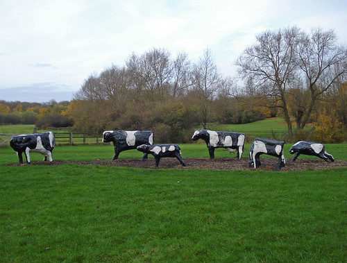
Photo by diamondgeezer

Categories
Training

50-50-50 Goal

Lea Valley (p597)At the beginning of this year, I set myself the goal of doing 50 hours of orienteering, 50 hours of running/spinning training, and 50 hours of cycling (not counting commuting, but including cycling to events.) Today is Day 127 – or 17.4 hours in, how am I doing?

Orienteering: 17.6 hours
Running/Training: 10.1 hours
Cycling: 15 hours

A three-week gap at the beginning of Apri hasn’t helped – got a bit of work to do.

I’ve just noticed that next year’s British Championships are at “Ysbyty Ystwyth”. Try pronouncing that the morning after 4 pints of Leffe…

The photo is from today’s cycle ride – I cycled up the Lea Valley, out of London and into Hertfordshire.

Categories
Training

Running Routes

Here’s some of my favourite trail runs I’ve done or would like to do shortly.

Epping Forest 18km – Covered by four orienteering maps.
Gorhambury 15km – From Iain’s house in St Alban’s.
Port Meadow 12km – My “standard” long circuit while at Oxford.

Categories
Notes Training

GMap Pedometer

After a long run on Sunday I did some post-run analysis, and found an excellent site, GMap-Pedometer, that harnesses the power of Google Maps and also USGS altitude information. Basically, you click on the map to draw a trail showing where you went, and it adds up the distance, throwing in mile/km markers and other nice things. Even better, the USGS altitude information means you get a complete profile of your run, so you can tell how much you climbed too. (Despite the website stating it’s only available in the US, it works just fine in most of the UK too – although the data can be quite inaccurate.) No more poring over OS Landranger maps trying to count the contours, or getting out a piece of string to try and measure the trail distance. Here’s the route I did.

Also, I drew a special “course” showing a Cross-Scotland walk that I’ve been meaning to do since 1997 but have still not got around to, largely due to lack of time and/or volunteers. The Great Outdoor Challenge is an organised walking challenge with a similar idea, and provided some inspiration for my original plans. The nice thing about the walk is you only cross 2 major roads, in 9 days and 130 miles of walking. (N.B. The GMap Pedometer trail of this route will take a little while to load, as it’s a very long trail.)

In case you are curious, the route would have been/will be:
Day 1 – Fort William to Corrour
Day 2 – Corrour to Ben Alder Cottage
Day 3 – Ben Alder Cottage to Dalwhinnie
Day 4 – Dalwhinnie to Glen Feshie (crossing the A9)
Day 5 – Glen Feshie to Linn of Dee
Day 6 – Linn of Dee to Braemar (“rest day” – 9km walking.)
Day 7 – Braemar to Glen Doll (crossing the A93, also the highest point of the route – 910m. Sadly, the Glen Doll YH is no more.)
Day 8 – Glen Doll to Bridgend
Day 9 – Bridgend to Montrose

There could be an extension out west (as Loch Linnhe is a sea loch, but not the “open sea”) and also a “high level” route that would be similar in distance and location, but climb Scotland’s highest Munros.

Categories
Training

50-50-50

Inspired by a discussion at Attackpoint, I’m going for a modest (i.e. achievable) New Year’s resolution for 2006: 50-50-50.

That is,

  • 50 hours of competitive orienteering.
  • 50 hours of training (probably mainly spinning in the gym.)
  • 50 hours of long-distance bike rides (i.e. >1 hour/day.)

That’s just under an hour a week for each of these. I’ll code a progress pictograph for the website here once I’ve got a decent number of hours under the belt.

Categories
Training

Attackpoint

I’m recording my event results (and any training I happen to do – probably including the bike commute to work!) at Attackpoint.

See here for my orienteering/training activity in the last 28 days.

So far, I’m not hugely impressed with Attackpoint. It looks slick, but I got numerous errors when trying to add my first entry, mainly as I was inputting the time in the wrong format. Also, there seems no way to delete the activity categories that accidently got added when I was trying to correct the above issue. Still, the training log is a nice idea and presumably a good motivator – and it’s been built from an orienteering perspective, which is unique and great. I’ll probably wrap up the commuting in to a single weekly aggregate entry.

Categories
Training

O-Ringen 2004: Training, Landvetter Öster (18 Jul)

Landvetter physical legAfter arriving in Gothenburg on Saturday on a horribly early morning flight, and getting so lost on the way from the airport (always an embarrassment for any orienteer) that we ended up twice as far away from the city than we started, no one was really up for too much orienteering. But the following day was the last day before the O-Ringen proper, so we picked the most interesting training area and went for a “free run” on the map. Of course, everyone was fresh from running in the easy southern England forests, and the longest suggested circuit on the map (around 7km) looked a cinch. It actually turned out to be a harder and much more physical area than the competition areas, and the steady drizzle didn’t help for an easy circuit. A rather scary “bridge”, or rather, a submerged plank, across a large marsh, caused many to pause for a considerable time. I had to cut my own circuit short after running out of time.

Landvetter long legThe first extract here was typical of the first part of the course. Going from 2-6, the “green” marked proved very rough indeed and I had to give up and retreat at one point. The marshes were extremely wet, cold and unpleasant – in sharp contrast, the competition areas would prove to have good, fast marshes, but I was initially nervous of using them after today.

The second extract shows the longest leg, 16-17, and again a combination of bad luck and extremely poor route choice led to a daft route, running through rough and then getting stuck in a horrible marsh. Note that the extract shows a couple of shooting ranges (!) that I ran by. No signs as to their purpose and no key on the map, it was a good thing there was no shooting happening… The correct route on this one would have been to stay on the road, avoiding the rough open below the range, and swung around only much later. Also I should have perservered to find the bottom path in the green, rather that trying thrice to gain it from the north and giving up. I then tried to go through a “seasonal” marsh that looked OK, but got nastier and nastier – at one point there was seemingly uncrossable marsh 360 degrees around me.

A bit of a battle really. The 1:15000 map was the first I’d run on at that scale for a very long time, resulting in a lot of distance mis-estimation, on top of the physical difficulties. It all looked rather forbidding for the O-Ringen proper, with the Gothenburg forests appearing to live up to their reputation of being extremely physical, but I was to get a pleasant surprise later in the week.

Categories
Training

The Back is Back (and more)

As expected, I’ve bounced back very quickly from Monday’s low back injury, and was back at work today. I didn’t make the event tonight though. Assuming the pain continues to decrease, Sunday’s event is looking good.

My parents must be reading all three of my weblogs like every 10 minutes. I post to Yep Sport pretty infrequently, yet my dad still managed to snag my last story within hours of me posting it. I wonder if he’s discovered aggregation? My mum’s already put a book in the post…

Man it’s hot here in London! It’s going to be an uncomfortable summer in the flat if it continues like this. I think I prefer Edinburgh’s climate.

Good to see BOF has got rid of (or at least reduced the prominence of) pictures of little kids pottering around string courses in parks, and replaced the front page photos with those of some real atheletes in action. Orienteering is Sport for All, but it’s the champions that should be on the front page of a national federation’s website. Now if only they could actually get around to finishing the website… And why oh why don’t they just use a weblog – looks 10 times better, for 10% of the effort.

Categories
Training

Injury Worries

My knee injury, which happened this time last year after I plunged my foot down a rabbit role while racing in a National, has recurred. The timing is unfortunate, as I’ve really come into fitness in the last few weeks, and seen my speed steadily increase. My injuries however always seem to happen after periods of relatively intense activity.

Unfortuantely I aggravated the injury further by attempting to run in the British Student Champs last week (more to follow on that.) The pain got too much after running down a bank and I had to bail out of a race I’d been looking forward to for several months. Even walking back to the start was exceedingly painful. Orienteering’s premier season really kicks off in a couple of weeks, so the timing just couldn’t have been worse.

Anyway I didn’t do any orienteering this weekend (I missed a club league event at Esher) and I’ve taken the last few days extremely lightly. I’m just hoping I’ll be able to run in the JK (Britain’s biggest event this year) over Easter. My form will have completely gone with no exercise in the build up, but that’s less important as long as I can actually make it into the forest!

C’est la vie.

Categories
Training

January Training Log

A very lazy month for orienteering, characterised by either not bothering to get out of bed for events, missing crucial trains, or turning up on the wrong day for the event… I also lay low to nurse a minor injury – my chest muscle, believe it or not, got strained in the Yellowcraigs event in December, causing much worry and needless concern (the pain was in the region of the heart!) As with most muscle injuries, staying indoors and taking it easy was the cure. I did however finally get around to going to the company gym that I had signed up for in November. And very nice it is too. I overdid one of the exercises though (often happens for a first time in comfortable surroundings) and felt it the following day.