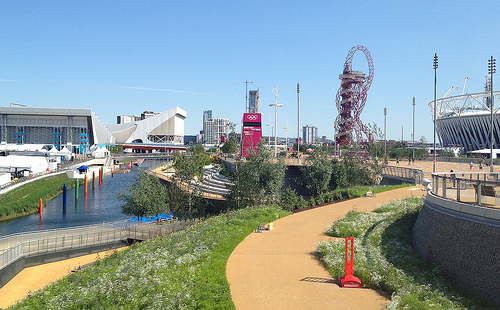
The Olympic Park in east London was a flurry of colour and activity during a few weeks in summer 2012, but since then it has been largely locked away – a parcel of land opened last year, but with a security fence, access only from certain points and at certain hours, it hasn’t really felt like a proper park. A few cycleways have also appeared, but considering the “blank slate” of the area, they are laughably awful. Tradtionally the excuse for London’s poor standard of cycle tracks is that the roads are too narrow to fit them in, or there’s too much traffic to close a lane for cyclists. Both of these are rubbish reasons for many of our streets of course, but the lack of positive and effective action (apart from in a few isolated places) has allowed places like New York to leap-frog London as cycle friendly cities – during Autumn, more people used the bike-sharing system in New York than in London. I really hope it’s not too late to fix these mistakes.
The good news is that a lot more of the park is due to open very soon. The Aquatic Centre and the Velodrome are due to open in March, along with the outside BMX, mountain bike and road tracks. I’m rather disappointed that we’ll have to pay to use the latter, I had originally envisaged all the bridges being open to the public at all times, but with two of the bridges are forming the circuit, this will represent quite a large part of the park that is fenced off. I appreciate the venue buildings need to be self-sustaining in funding but it’s a shame that the outdoor as well as the indoor circuits are pay-to-play.
Then in April the south of the park reopens, and the Orbit. The orbit will, I’m sure, be about as popular as the cable car, at least until the view improves, but with the southern part of the park opening up, finally there will be a large, green(-ish) space which just might start to feel like a proper London park.

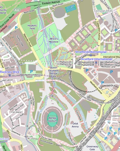
One thing that is going to need updating is the map. The official one is really not that great (What do the dashes mean? What do the dots mean? Why are the open areas outside the park shown in the same grey as closed areas inside the park?) so we’ll have to turn to the crowdsourced map of choice, OpenStreetMap. This map (above) isn’t looking great at all either at the moment – some features that were around only in 2012, such as the athlete’s access tunnel across the Greenway, are still on there. Red dashes show out of bounds paths – how many of these will come in bounds in March/April? So we’ll need a Mapping Party some time there in April/May, and after that, the map should look pretty good.
The park was great for a few weeks in 2012, but the slow pace of opening, and the efforts so far, have been disappointing. But despite my grumbles above I’m greatly looking forward to the park opening, them sorting out the cycle lanes and access, and it maybe becoming, one day, a great space for cycling through, jogging in, or maybe even a bit of park orienteering?
Map © OpenStreetMap & contributors.
2 replies on “Olympic Park Rising”
Hello Ollie, I am only going to write about off-topic matters: Congratulations on consolidating your domain names. Obviously I did manage to find the new location of your blog relatively trivially, viz by reading the entire content of oobrien.com until the location was revealed. Anyway, wot no orienteering posts? Maybe there is no orienteering happening.
Ah yes, and the original reason I was looking amongst your various domain names past and present today was to point out that your so-called periodic table appears to have very little to do with the periodic table. Also, it appears to lack any intrinsic periodicity of its own. These undeniable facts make its designation as a periodic table dubious.
Hope this helps.
Yes, the Periodic Table was more to do with the (original) design as a series of squares in a grid, with a symbol and value, than any formal link to chemistry. I should think of another name.
New locations for the blogs are:
work – oobrien.com
leisure – blog.oomap.co.uk