Categories
Leisure

Promenade Plantée

As part of a brief trip to Paris, I recently walked the western part of the Promenade Plantée raised linear park or “rail trail”, in the southern part of the city. The Promenade Plantée, also known as the Coulée Verte, predates the well known “High Line” in New York City (and a potential London version) by many years. Its western part is around 1.6km long – about half as long as the NYC High Line and twice as long as the proposed one in Camden. It is raised a few metres above the streets, on a long viaduct, allowing for the characteristic “street scene from above” views:

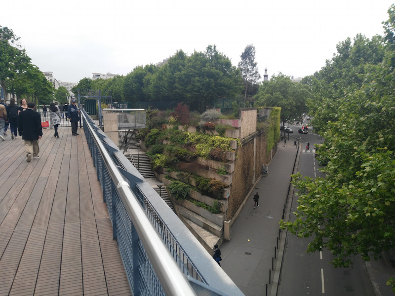
Around half way along, the route crosses a long, wooden bridge (not an original from the time when it was a railway line) which dips down into a park in a surprisingly gritty and unattractive part of Paris, before continuing eastwards under the street level, in a series of tunnels and cuttings. This is also a key access point to both sections, with a set of steps and a lift:

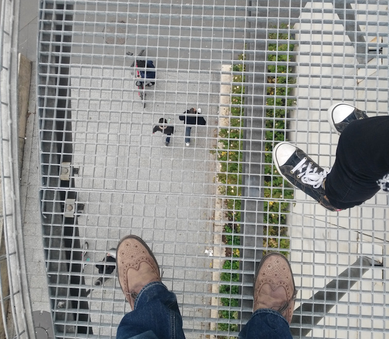
There is also a short section here where you can look down beneath your feet:

I didn’t walk along the section section, which is always open and accessible to bicycles as well as pedestrians. The western section is pedestrians only and is locked at night.

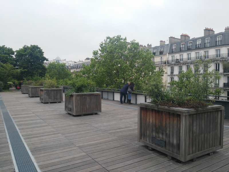
The park, being a former railway line, is generally narrow, but does broaden in a couple of sections:


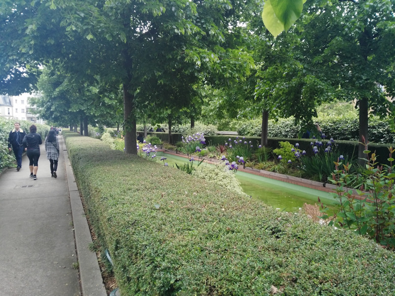
It also has some interesting detail, for example, near the western end, the walker passes under a number of wooden trellises, full of plants. Further on, the path splits into two, passing either side of a narrow but long pond, bordered by hedges but with a couple of small bridges connecting the two paths:

A section with tall bamboo on either side, creating a natural tunnel, was also of interest.

There was a little bit of antisocial behavior in a couple of sections, but this didn’t spoil the general atmosphere. It was surprisingly busy, with a mixture of local walkers, families (it was a Sunday afternoon) and quite a lot of joggers.

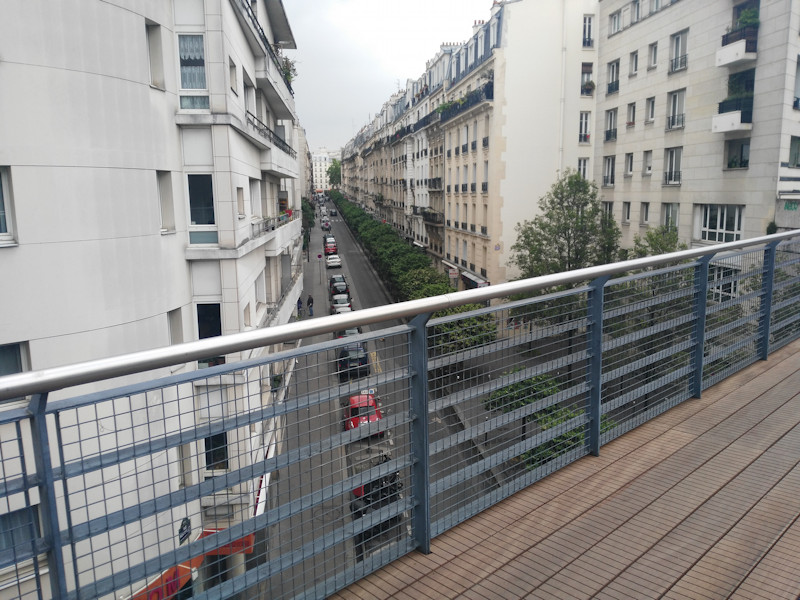
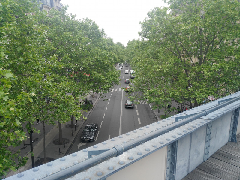
Some of the bridges are the original railway bridges. These have solid iron sidewalls, but the wooden decking has been slightly raised here, with a safety bar added to the top of the sidewall, so that users of the walkway can easy (but safely) see over and along the streets below:

Like the New York City version, there is the interest of passing through (and over) a building, which intrudes on to the route in a dramatic way. Unlike New York City’s version though, there is no trace of the original railway track, with the ballast and rails completely replaced by a mixture of wooden decking and concrete paths, along with plenty of flowerbeds on either side.

It was good to walk the Promenande Plantée, and great to see it so well used, considering its age and that it is not in perfectly maintained condition. Even though it is only 1.6km along, I took a good hour to do the walk, allowing plenty of time to study some of the murals and other small artworks along the route, both official and unofficial (including a piece by Invader), as well enjoying what is essentially a long, thin public roof garden in the heart of a metropolis.

Categories
Technical

Panama’s Population Geographies

Panama is a Central American country with around 4 million population. The country is split into 10 provinces (including one that was split from another in 2014). The population is obliged to register for and obtain an ID card, or “cedula” which contains an interesting attribute. The prefix of their ID number indicates their province of birth. This not only allows the mapping and analysis of surname (and other) demographic information across the country, but also, if combined with information on current location, even allows for a rudimentary analysis of internal migration in the country.

This official document contains lots of useful information. Subsequent to this, the “Panama” province within the country has split into two, with the westernmost section becoming Panama West and gaining a new province number 13. In practice, the great majority of people living here retain the prefix 8 as the population with “13-” prefixes will be too young to have appeared on school attendance lists, jury service lists, exam candidate lists or government worker salary transparency lists. Here is the very No. 13: Ashly Ríos, getting the number 13-1-001. (People are required to obtain their number by the age of 18 but you can be registered at birth.)

For most people, born in Panama, their cedula number prefix indicates the following provinces of birth:

Province Cedula prefix
Bocas del Toro 1
Coclé 2
Colón 3
Chiriquí 4
Darién 5
Herrera 6
Los Santos 7
Panamá 8
Panamá Ouest 13
8 (pre-2014)
Veraguas 9
Guna Yala (indigenous province) 10
3SB (pre-1953)
Madungandí (indigenous sub-province) 10*
8PI (pre-2014)
Wargandi (indigenous sub-province) 10*
5PI (pre-2014)
Emberá Wounnan (indigenous province) 11
5PI (pre-1983)
Ngäbe-Buglé (indigenous province) 12
1PI, 4PI or 9PI (pre-1997)

* These were briefly assigned No. 13, before being changed to 10.

The format of the cedula number is generally X-YYY-ZZZZ where X is the province number, YYY is the registry book number and ZZZZ is the number within the book. However, for certain groups, the prefix is different. If SB appears after the province prefix, this is an indication that the person was born in Guna Yala (formerly called San Blas), but before it became a standalone indigenous province. Other indigenous areas, some of which have not formally become provinces, were indicated by PI appearing after the prefix of the former or enclosing province, or AV if very old (born pre-1914). However, the numerical codes are now used.

Panamanians born outside the country get “PE” as their prefix instead. Foreigners are assigned “EE” while they retain their immigrant status. If they gain permanent residence rights, they are assigned “E”, and if they become full Panamanian citizens, they are assigned “N”. PE, N, E and EE do not officially have an associated province prefix, although one is occasionally added in third-party lists, or “00”. So, these people can also be assigned a separate ID, starting with “NT” and with an associated province prefix, this is a temporary ID issued for tax purposes, rather than a full cedula number.

Categories
London

Camden Highline

A couple of years ago, I wrote about a number of possible London “High Lines”, London’s own raised “rail trail” to New York City’s High Line and Paris’s Promenade Plantée.

Now it looks like the best one could be happening. Camden Town Unlimited, the business improvement consortium for the area, are proposing a Camden Highline, which would run for around 0.8km, between Camden Town and Camley Street, which is itself 0.8km from the back of King’s Cross Central.

Below is the start of the route, there is a little park here which could provide space for an access point. From the photo, it looks like the operational railway is close, but the route quickly moves away, around the back of Camden Road station.

Although there is no public access to the route itself currently, you can get a good idea of the space and route, from Google Streetview, looking up from the streets below. I have included views from below the various bridges, in this post.

The route uses a surprisingly wide corridor of unused railway, mainly alongside the existing North London Line but including a substantial hidden space behind Camden Road station, and seven bridges across eight roads. The route is as wide as 18m in some sections, with narrower sections at either end.

The route ends here (photo below), at Camley Street. To the left is a new bridge for the railway. There is actually still space on the new bridge here for a narrow walkway, and a ramp on the other side means no need for a new access point. However, the land in front is also currently empty, and so could quite easily accommodate a new route down, potentially as part of a wider development of the plot.

See the official Camden Highline website. All photos (c) Google. Illustrations from Camden Town Unlimited.

Categories
London

Crossrail Opening Sequence

Crossrail’s Elizabeth Line will launch in the following stages:

    • Phase 0 – May 2015 – TfL takes control of the Liverpool St (high level) to Shenfield line, a single section with no forks.
    • Phase 1 – May 2017 (above) – The new Crossrail trains start to appear on the Liverpool St (high level) to Shenfield line, a single section with no forks.
    • Phase 2 – May 2018 – TfL takes control of the Heathrow to Paddington (high level) line and introduces Crossrail trains to it. TfL Rail is now two disconnected sections with no forks.

    • Phase 3 – December 2018 (above) – Services start running from Paddington (low level) to Abbey Wood, via Liverpool Street (low level). Services formally switch from being branded as TfL Rail to being the Elizabeth line. First trains through the centre. Crossrail has three disconnected sections, and no forks.
    • Phase 4 – May 2019 – Trains from Paddington (low level) to Shenfield, joining the existing service to Abbey Wood. Crossrail has two disconnected sections, with the eastern section forking twice. (The second eastern fork is a reverse one – a small number of trains will continue to start from Liverpool Street (high level) to Shenfield, missing Whitechapel and joining at Stratford.)

  • Phase 5 – December 2019 (above) – Full services running, all via Paddington (low level) and Liverpool Street (low level), from Reading too Shenfield and from Heathrow to Abbey Wood. Crossrail is a single, connected railway, with a fork to the west and two forks to the east.

[UPDATE] Following the announcement of Crossrail’s delay, it looks like Phase 3 will actually be the services running from Reading into Paddington – which will become part of TfL, in December this year. With luck, some time in early 2020, then services will start running between Paddington and Abbey Wood – a revised Phase 4. This is the separated section from existing National Rail services, so it doesn’t need to wait for the May or December timetable changes. I would imagine that the new Phase 5 – the Whitechapel link, could start in May 2020, with a new Phase 6 – services running from the west into the new tunnels, maybe in December 2020.

Categories
Orienteering

OpenOrienteeringMap – Postcode Search Fixed

A minor update to the GB edition of OpenOrienteeringMap – the postcode search has been fixed. Typing in a valid GB postcode should now jump to the map to the centre of that postcode. Note that postcode search for Northern Ireland is not available.