Street-O runners who read this blog may be interested in the most recent posting on my research blog.
Categories
Street-O runners who read this blog may be interested in the most recent posting on my research blog.

Photo by RachelH_ on Flickr.
Exciting news for the second City of London orienteering race that is happening on Saturday 12 September – I’ve just heard that we have been granted access to parts of the Temple complex for the race, with kind permission of the Inner and Middle Temples.
The Temple is a fascinating and beautiful part of the city of London – it’s full of cloisters, quadrangles and gardens. It is the legal heart of the city, with numerous barristers’ chambers in the old and attractive buildings, making up the Inner Temple and the Middle Temple, two of the four Inns of Court. Also situated in the complex is Temple Church, of Knights of the Templar (and Da Vinci Code) fame. Curiously, the area not legally part of either the City or Westminster, instead it acts as its own local authority.
I’m not the planner for this year’s race, although I am updating and extending the map. News of access to the Temple is a mixed blessing for me – it will undoubtedly be a superb area to run in and will enhance the race, but it also means I have my work cut out to have it properly mapped in time.
Anyway, if, due to permissions issues in Oxford and weather delays in Cambridge, you are longing for the kind of tight, intricate orienteering you get around Oxbridge colleges, then the City of London race this year could be the next best thing. (Note however that not all courses will be using the Temple area.)
Entries are filling up nicely now so get yours in well before the closing date!
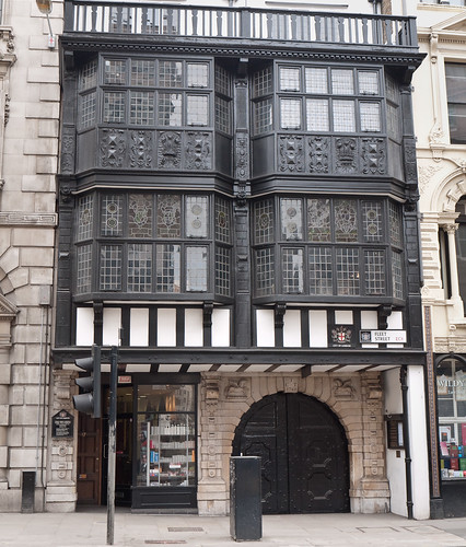
Photo by SWH on Flickr.
Well, that was good.
My sixth Scottish 6 Days international orienteering competition in Perthshire/Tayside has just finished – around 3000 competitors and seven days of competition (including the supposed “rest” day). Six sunny days and just one day of persistent rain, unfortunately it was the most rugged day. Still, it meant the other days were appreciated even more.
Here’s my writeup in my training log.
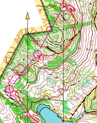
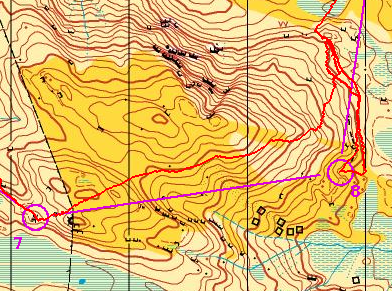
Here’s some map extracts, showing my most outrageous mistakes and some nice bits of the areas:
Day 1 was a tough, physical day, this actually turned out to be my best result of the week. I was frustrated at not being able to run at any speed on the steep, slippery hillside. My only mistake of any significant size was stopping too early on the approach to No. 8 and searching in the wrong place, resulting in an unnecessary 25m climb.
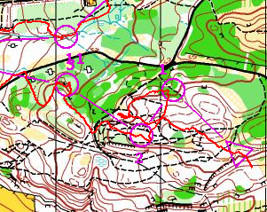
My main mistake on Day 2 was running beside the wrong hill at the start, and getting confused in the jumble of MTB-tracks, none of which I thought were marked on the map. They, of course, were, and I was in the wrong place. Note the interestingly steep approach to the start flag.
Day 3 was the only rainy day, a shame as it was probably the grandest area. I was OK until I hit the open moorland, where I made the biggest mistake of my week, running over the big hill and coming off it too far to the north. The mistake was compounded by a parallel error once I had descended.
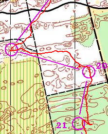
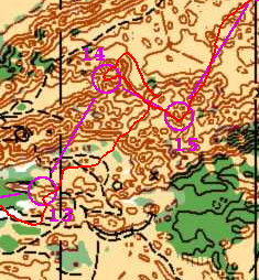
Tentsmuir (Day 4) was a joy to run in after the climbs of the previous days, and I felt I had a very strong time – of course, everyone else did well, too. It was a nice and sunny day – shame about all the ticks.
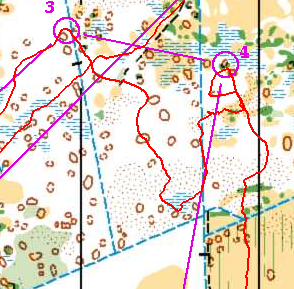
A pretty horrible mistake from No. 3 to 4 in a fantastically complex bit at the beginning of Day 5. I completely failed to see the second vertical blue line to the right, which was an obvious ditch and would have been useful to run blind to. Instead I personally inspected each small mound in the broken area to the south.
Much of the rest of Day 5 was on – or running between – big sand dunes. This was the most impressive complex, I got lucky here, and didn’t have major problems – the way to No. 14 was fixed quickly as I knew what I had done. Large numbers of other people were stopped and looking very lost – quite a few on my course lost ~10-12 minutes here.
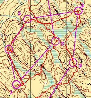
Finally, a very physical and technical, but satisfying, end to the week. Only the marshes could be run along at good speed (e.g. 6-7), the heather on the open areas was pretty tough. I came out of No. 3 in the wrong direction but fixed it on the way. No. 6 was lower down than expected, it wasn’t just me that made this mistake though.
Best bits of the week were:
Worst bits of the week were:
All in all probably the best Scottish 6 Days event I’ve been to.
There’s a few City Race orienteering events coming up this autumn – if you like this format, don’t forget to enter them!
Also – have a look at this map of an orienteering race in a (multi-storey) shopping centre in Switzerland (via @highlandsopen on Twitter).
Publicity for the 2009 City of London Race by Brooner.
Michael (of the Okansas blog) has recently mentioned two quite interesting orienteering-related ideas:
1. The COMO project, which is looking to use OpenStreetMap data to create orienteering maps. This is very similar to (although more advanced than) my own work – I looked at creating Street-O orienteering maps from OpenStreetMap data for my dissertation for my MSc in GIS last summer, and additionally built an Osmarender-generated/OpenLayers-based based map for viewing and printing such maps easily – although I never got around to releasing it publically. I’ve subsequently thought of extending the process for “proper” orienteering maps, while keeping the data in the OSM database. The COMO project is looking at creating “proper” orienteering maps, converting OCAD data into a form which can be read into a special database separate from the main OSM one.
As an aside, it would probably be easier not using the OSM flow or API, but rather a PostGIS database to store the data, with GIS applications such as Quantum GIS to do the editing. Mapnik as the rendering engine is considerably easier to set up, configure and use than Osmarender, too.
2. Seek ‘n Spell, which is an iPhone game, uses the internal GPS, the ability to broadcast your location to a central server, and aerial photographs, to create multi-player games where you can run around, collecting letters to spell words. See Michael’s post and also the video – the action looks uncannily like a combination between SLOW’s Mobile-O and a “normal” mass-start score orienteering event. The game-view reminds me of watching an animation of a race in Routegadget. The concept and the finish quality of the app looks great but the name is a dreadful pun – hopefully they’ll rename it something a bit snappier.
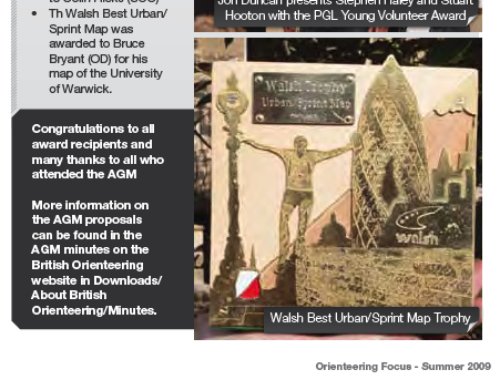
Just seen a picture of the Walsh Trophy, a new award for Sprint/Urban maps produced in the UK, in the most recent issue of Focus magazine.
Here it is:
The design is of an orienteer leaping off the front of a security wall in front of the Gherkin building in the City of London – right by one of the “spectacular” controls that formed part of the inaugural City of London race I put together last year. In fact, it’s based on this picture by Chris5aw, of one of the competitors (a Spanish runner, if I remember correctly), which also was on the front cover of an earlier Focus issue. The Gherkin has been moved further back, in the trophy design, so that it can be completely seen. The wall is now a brick wall instead of black marble, and the lamppost has been made considerably more ornate!

I’ve added a new feature to the map of orienteering events – you can now see the range of available courses for each event, via the set of coloured boxes on the right hand side. Mouse-over or click a box for more details.
I’ve also refined the links to the road-maps and the Geograph photos, and added in the region that each event is in, you can also filter by the region. Due to a quirk with the data source at British Orienteering, this information is only available ten weeks into the future, hence why the Scottish 6 Days don’t yet show as being an event in Scotland.
Finally, there is now a way to pre-filter the results (and pins on the map) to be for a certain region or club – this is an “undocumented” feature, to access it you append an “&c=club” or “&c=region” to the end of the URL, using the acronym for the club or region concerned. Use NIOA, SOA and WOA for Northern Ireland, Scotland and Wales respectively, and the two-letter codes for the English regions.
For example, to show all the events in the south-east of England (SEOA region) use http://www.oobrien.com/map/?p=E1&c=SE.
Here’s a Christmas present – a peak at a partially completed small section of the City of London map. Scale: 1:625 at if viewed on a 72dpi screen.
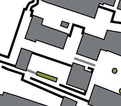
What’s shown: Buildings, passable and impassable walls/fences, and flower beds.
What’s not shown: Roads & pavement boundaries, underpasses, out of bounds areas, steps*. A couple of short walls are also missing.
* I hate drawing steps. Really, they are the most tedious part of creating orienteering maps. So, generally, they are the last thing I draw when doing the cartography.
Interesting extract from the most recent BOF events committee minutes:
Agenda item 07/24: Use of GPS systems at orienteering competitions – Competitors are currently not permitted to use a GPS device as an aid to navigation at any competition registered with British Orienteering. However at this time Rules Group was unwilling to ban the carrying of a GPS device by an individual who wished to use it as an aid to personal post-event analysis. An item covering this should be placed in the next publication of Focus.
This is encouraging as it matches my own thinking. I carry a GPS at some events – but it remains concealed, such that it not easily useable during the event, but useful for post-race analysis. As long as it remains in my pocket, I don’t consider myself to be “using” it during the race. Still, I probably would leave it at home at a British Championships…
On an unrelated note – am waiting with anticipation for the new BOF website going live, especially the “My Orienteering” information, integrated results service athlete stats. Also sounds like they’ll be doing an events map, like my Google maps mashup of the fixtures list. I talked to the BOF CEO before the SCOA AGM a couple of weeks ago, and he was promising a fairly spectacular revamp of the site. Looking forward to it!
Oh dear. I had starting running in the Bushy Park Time Trial, a 5km trail race every Saturday at 9am in SW London, as a way to get me up and out of the house on mornings when there was no orienteering event. But now I’m choosing to go to it in preference to the very orienteering events I was looking to supplement.
Why? Because there’s a few things about it which beat any orienteering event:

Nice Try: I fail to make a 14 year old’s day by beating him in a sprint to the finish line. Still, we both got personal bests so he can’t be that unhappy. Photo by Paul SH.