Categories
Orienteering

OpenOrienteeringMap and MapRunF

OpenOrienteeringMap, a website for creating a PDF street orienteering map of anywhere in the world based on OpenStreetMap data, has seen a massive upsurge of use since various countries starting locking down their populations during the Covid-19 crisis. Suddenly, many people have found their exercise limited to around their home area, and, if they aren’t lucky enough to live on a “proper” orienteering map, OOM is a great way of getting a simple map quickly – with blue plaques and (for the UK) postboxes pulled in with a single click as potential control sites.

At the same time, there have been a number of initiatives to combine the basic orienteering concept of navigating with a map between points, with the use of GPS receivers on the smartphones most of us carry, and their increasingly high-resolution screens, to virtually “punch” a control by being in the correct location, and carrying the map on the phone.

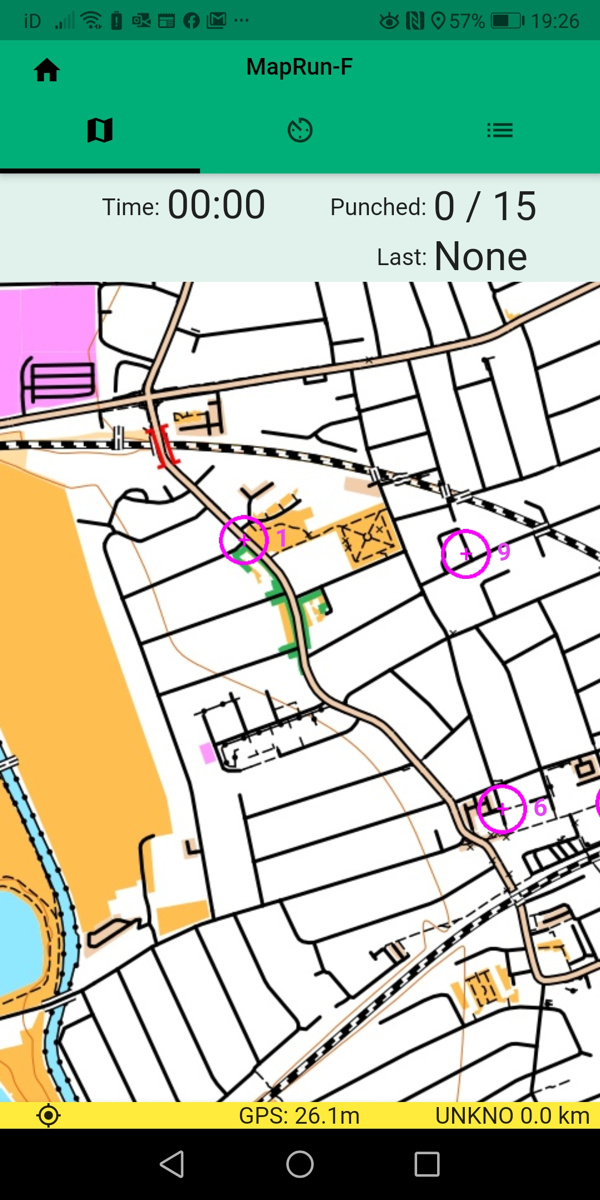
MapRunF is one such project – with an Android and iPhone app. Courses can be created on the phone itself using Google Maps aerial imagery, or .ocd format maps and courses loaded in from OCAD or Mapper. But if you want the authentic orienteering experience without needing to do “proper” mapping, OpenOrienteeringMap now offers two buttons to easy the import into MapRunF.

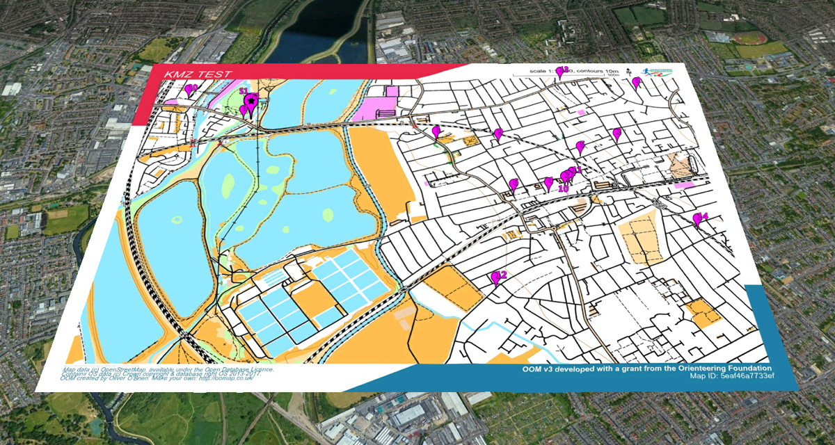
Once you’ve saved your map and course, you can click on the KMZ and KML buttons to download a map and courses file respectably. You can then upload these to Check Sites, note down the ID number, and load it into your phone running MapRun F. Straight away, you have your orienteering map and courses, ready to run!

The KMZ map file does not include the courses or start/finish marker, as these are contained within the KML course file. However, it does contain any crossing point “bridge” symbols or do-not-cross “X” markers that you added.

The KMZ and KML files also work in Google Earth:

Try OpenOrienteeringMap – the UK and Ireland editions update daily from OpenStreetMap, while the Global edition updates once or twice a year – but you can create a map at any time! Look out also for a daily updating Australia version soon.

Categories
London Orienteering

London City Race 2014

9641029424_9771316fec_z

Having co-founded and been heavily involved in the organisation of the London City Race over the last six years, this year I’m taking a step back and looking forward to being a competitive runner at the seventh event, for the first time. After five years rotating around various parts of the City, and last year over at Canary Wharf, this year, it’s back to the centre of the City. The London City Race is just one of a whole series of urban races in major European cities this autumn, including Brussels (on the same day), Paris (the weekend after), and Porto, Edinburgh, Stirling and Barcelona in the following weeks. Four of these races form part of the City Race Euro Tour, with Barcelona acting as the final race with series prizes. It is in fact quite possible to run both Brussels and London, despite them being on the same day, thanks to wide start intervals, a well timed Eurostar train, and both events being near their respective termini.

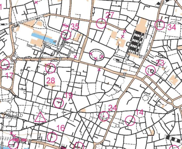
The first official London City Race was back in 2008, but in fact there were a couple of “prequel” races, although those running them may not have realised that. The first was a SLOW Street-O race taking place in the City in late 2007, on a Tuesday evening during the rush-hour. (An example of the “barebones” style map used is below – this is actually one from a later Street-O in the same area.) Amid the post-race analysis in the pub, it was agreed by all that the alleyways of the City were a lot of fun to run around. Conveniently I had taken a year out to study a MSc and therefore had the appropriate amount of free time to draw up a map. Being a Mac user, I needed a different solution to OCAD, so used Illustrator/MapStudio.

The process of producing the completed map, with courses, was a bit convoluted, so there was a second “prequel” race at Queen Mary University, using a map prepared in an identical way. This, my first ISSOM-standard map, proved to be fine, and so I and my co-organiser (Brooner) moved on to the race itself. Our controller, Simon Errington, proved invaluable, going well beyond the bounds of a traditional controller’s role to ensure the best possible event was put on. Having a large and experienced club (SLOW) was also immensely useful, with an army of volunteers to draw on for the race day itself. After the first, successful event, it was just a case of adding a new bit to the map each year (roughly one square kilometre a year has been added) and also moving the start and finish each time, to ensure that competitors could take part year after year, having a new experience running through the City with each race. We have also always tried to ensure the race has had a high profile as possible to the general public, choosing highly visible finish arenas, using race bibs which display the name of the race, making marshals very visible (red t-shirts!) and marketing the event as widely as possible, including to running clubs and the mainstream media. With have been lucky enough to have been sponsored by Clif Bar, from the very first race, which means we have now given out over 5000 complimentary Clif Bars to finishers.

I purposely know little about the club’s plans for this year’s race except that it is back in the City, likely the core part, and will hopefully include the classic Barbican Estate, famously so hard to navigate through that yellow lines used to be painted on the ground to guide people to the nearest exit! I would love it to also include a loop past the iconic Gherkin skyscraper, but have absolutely no knowledge of if this is the case. Probably the most iconic view of the London City Race, the Gherkin appears on the Walsh Trophy, BOF’s award for the best sprint/urban map of the year, and also appeared on the front cover of their Focus national magazine a few years back.

This year’s race has the map in OCAD – the conversion from Illustrator was pretty painful, but this does allow other members of the club the ability to update it. Sadly the City evolves around us year by year and some of the classic alleyways are being lost as the City authorities realise that fully segregating roads and people doesn’t work (except for orienteering!) Those who ran in the 2012 event, which started near, and finished in, the Barbican Estate, might be interested to know that the whole start area has now been demolished, including several nearby footbridges. The replacement buildings will have less of a “public realm”. Nonetheless there is still plenty of interest in the City, for orienteers and urban explorers alike. The Barbican Estate itself isn’t going anywhere, and the alleyways around Lombard Street, where the medieval coffee houses of the City used to be, are still very much intact.

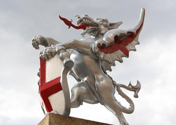
Entries are now open and already there are nearly 100 entered, including a strong overseas entry which should make this the most international of the UK’s now numerous urban races. The theme for this year’s race is the City of London dragons which guard each of the main entrances to the Square Mile. Be sure to order a limited edition technical top when you enter. See you in London (and maybe Brussels too!)

Photo above by Darkdwarf on Flickr. Below: A Street-O map of the City, based on OpenStreetMap data.
Screen Shot 2014-06-01 at 20.15.04

Categories
OpenStreetMap Orienteering

The COMO Project and Seek ‘n Spell

Michael (of the Okansas blog) has recently mentioned two quite interesting orienteering-related ideas:

1. The COMO project, which is looking to use OpenStreetMap data to create orienteering maps. This is very similar to (although more advanced than) my own work – I looked at creating Street-O orienteering maps from OpenStreetMap data for my dissertation for my MSc in GIS last summer, and additionally built an Osmarender-generated/OpenLayers-based based map for viewing and printing such maps easily – although I never got around to releasing it publically. I’ve subsequently thought of extending the process for “proper” orienteering maps, while keeping the data in the OSM database. The COMO project is looking at creating “proper” orienteering maps, converting OCAD data into a form which can be read into a special database separate from the main OSM one.

As an aside, it would probably be easier not using the OSM flow or API, but rather a PostGIS database to store the data, with GIS applications such as Quantum GIS to do the editing. Mapnik as the rendering engine is considerably easier to set up, configure and use than Osmarender, too.

2. Seek ‘n Spell, which is an iPhone game, uses the internal GPS, the ability to broadcast your location to a central server, and aerial photographs, to create multi-player games where you can run around, collecting letters to spell words. See Michael’s post and also the video – the action looks uncannily like a combination between SLOW’s Mobile-O and a “normal” mass-start score orienteering event. The game-view reminds me of watching an animation of a race in Routegadget. The concept and the finish quality of the app looks great but the name is a dreadful pun – hopefully they’ll rename it something a bit snappier.

Categories
Orienteering

Walsh Trophy

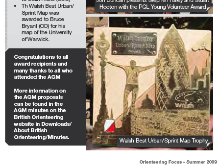
Just seen a picture of the Walsh Trophy, a new award for Sprint/Urban maps produced in the UK, in the most recent issue of Focus magazine.

Here it is:
walshtrophy

The design is of an orienteer leaping off the front of a security wall in front of the Gherkin building in the City of London – right by one of the “spectacular” controls that formed part of the inaugural City of London race I put together last year. In fact, it’s based on this picture by Chris5aw, of one of the competitors (a Spanish runner, if I remember correctly), which also was on the front cover of an earlier Focus issue. The Gherkin has been moved further back, in the trophy design, so that it can be completely seen. The wall is now a brick wall instead of black marble, and the lamppost has been made considerably more ornate!

Categories
Orienteering Events Log

Battersea Park Race

The second of this summer’s SLOW Park Race Series was last night, at a rather special venue – Battersea Park in south-west London. The last time this area was used for orienteering was at the Sprint finals of the Orienteering World Cup competition in 2005 – if it was good enough for the world’s elite, it was good enough for me!

The park is quite ornamental and I was expecting a run high on dramatic views but short on technicality, however Abi and Matthias planned a excellent Long course which got steadily more technical towards the end – I started making quite a few mistakes after the half-way point, and saw other people making bigger ones. My worst was not reading the control description at No. 14 (it is a sprint area after all!) and going round the Japanese Pagoda rather than up onto its plinth. The hot and humid weather probably didn’t help with the concentration either. There was some excellent long legs allowing for quite a bit of route choice – there’s too much “stuff” in the park to allow running along the leg line, unlike at Clapham Common a couple of weeks ago.

There was a great turnout – over 70 people started the Long course which is definitely a record for this series.

Looking forward to the next one in two weeks in Ravenscourt Park and next week’s Mobile-O (an orienteering race guided by mobile-phone!)

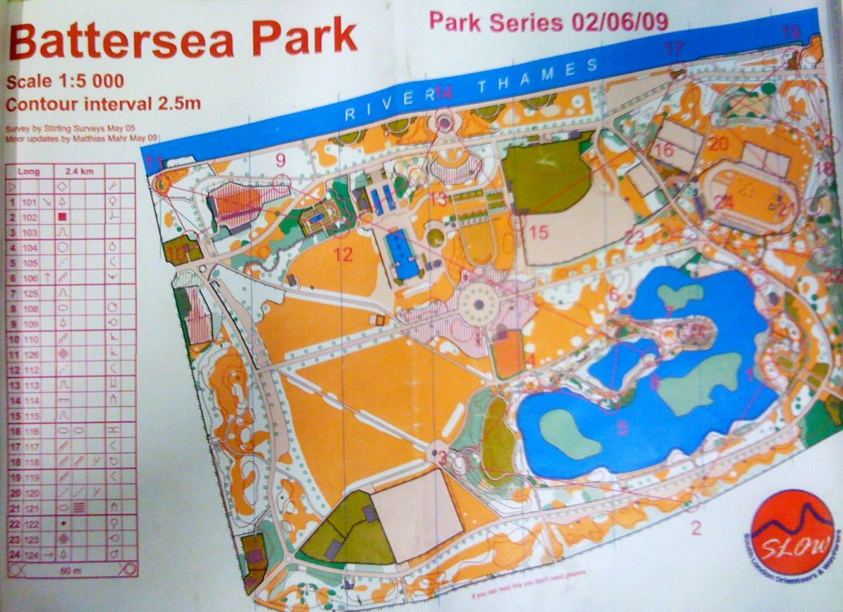
Here’s the map – pic snapped on my iPhone, hence the rubbish quality:
battersea

Categories
Orienteering

At-a-Glance Courses

Course Indicators
I’ve added a new feature to the map of orienteering events – you can now see the range of available courses for each event, via the set of coloured boxes on the right hand side. Mouse-over or click a box for more details.

I’ve also refined the links to the road-maps and the Geograph photos, and added in the region that each event is in, you can also filter by the region. Due to a quirk with the data source at British Orienteering, this information is only available ten weeks into the future, hence why the Scottish 6 Days don’t yet show as being an event in Scotland.

Finally, there is now a way to pre-filter the results (and pins on the map) to be for a certain region or club – this is an “undocumented” feature, to access it you append an “&c=club” or “&c=region” to the end of the URL, using the acronym for the club or region concerned. Use NIOA, SOA and WOA for Northern Ireland, Scotland and Wales respectively, and the two-letter codes for the English regions.

For example, to show all the events in the south-east of England (SEOA region) use http://www.oobrien.com/map/?p=E1&c=SE.

Categories
Conferences

MSc Dissertation

Last year (2007-8) I studied for an MSc in Geographic Information Systems, at City University London. The course was taught by an excellent team of academics and I can thoroughly recommend it as a good, technology-focused introduction to GIS. The highlight was the field-trip, a week away in the Lake District, carrying out three two-day projects, each involving planning, data gathering, preparing and presenting the findings.

The summer last year was spent researching and writing the dissertation. It is entitled “Use of a GIS for Production and Maintenance of Street Orienteering Maps: Can a GIS and Spatially Aware Data add Value to Orienteering?” and can be downloaded from here (24MB, 102 pages).

You almost certainly don’t want to read 102 pages, so there is an extended abstract here (1MB, 5 pages), entitled “Creating and Maintaining Street Orienteering Maps using OpenStreetMap”, which appears in the “Proceedings of the GIS Research UK 17th Annual Conference”, aka GISRUK 2009. I presented a poster summarising the work at the conference, which is reproduced below – linked to a larger version.

Poster for GISRUK 2009