Categories
Training

A New Method for Creating Street Orienteering Maps

This is a poster that I will be presenting at next week’s GISRUK conference in Durham. It is a summary of my Masters dissertation that I wrote last summer. The dissertation itself focused on areas and data in London, however thanks to LivingWithDragons‘ (and others’) excellent data-gathering for OpenStreetMap, Durham is similarly well mapped, so I customised the example map to be Durham itself.

The background, by the way, is a faded greyscale version of the map for much of London, which came from a “Slippy” street orienteering map of the metropolis that I’ve created but never got around to releasing, however it does show the extent of OSM’s London coverage now – pretty impressive.

durhama3

Click the graphic to see a larger version, but you’ll have to come to Durham yourself to see the original in its A1 glory.

Categories
Training

Google Street View London finally here

…and not just London. It covers 25 cities in the UK.

There are some omissions in the coverage of course – e.g. Chancery Lane is a notable missing street. But my home street in Hackney is there, and the imagery extends right out to the edge of the metropolis.

Here’s some fare-dodgers getting booked by the police, outside the main entrance to UCL.

Photo Copyright Google.

Categories
Training

Trees on OpenStreetMap

I noticed for the first time yesterday, that individual trees are being stored in OSM, and being rendered on the default OSM/Mapnik map:

osmtrees
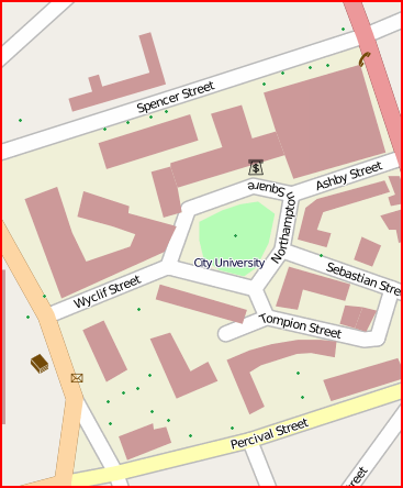
The green dots are points tagged with natural=tree, here at City University London.
OSM documentation for the natural=tree tag

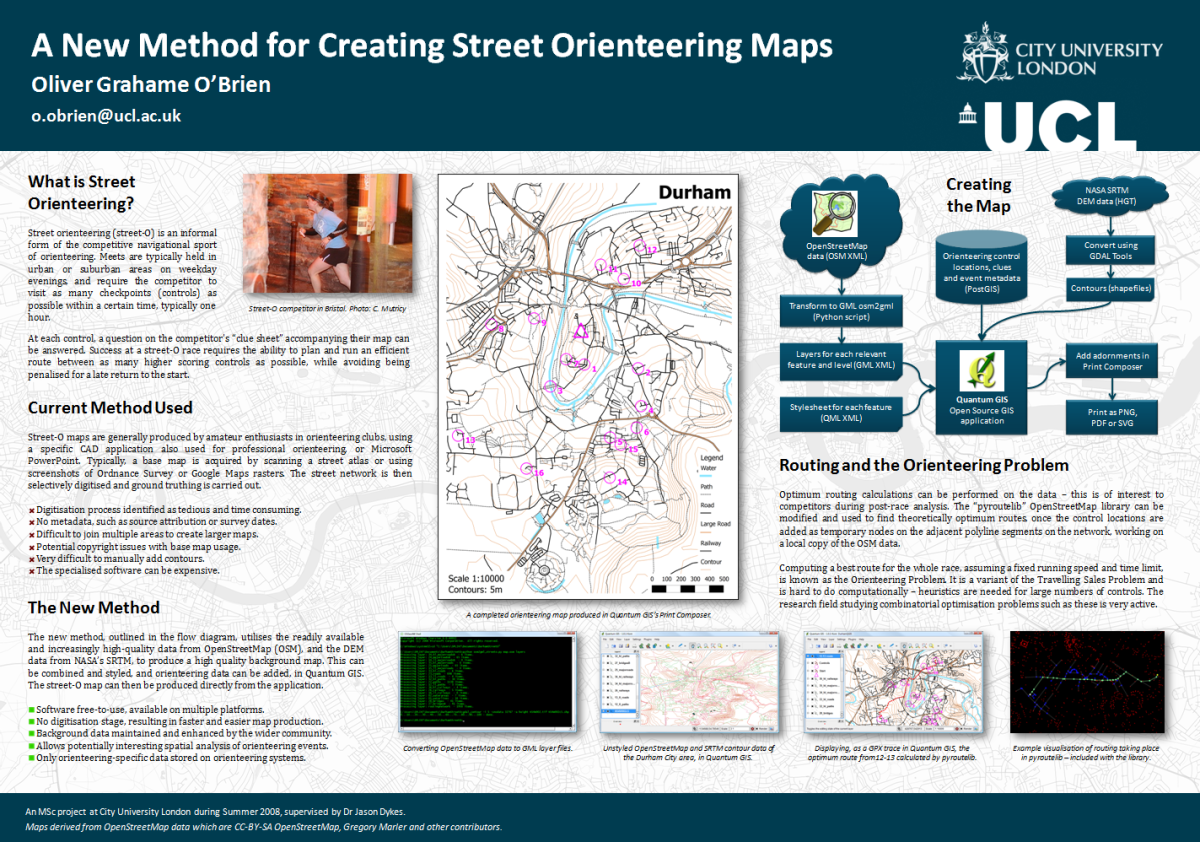
This got me thinking – might I be able to build a “proper” orienteering map using entirely OpenStreetMap? Street-O* maps can already be produced with OSM data – this was some work I did last summer, and also am working on – but being able to produce an ISOM** map directly from OSM data is quite appealing. (ISSOM*** might be harder, as this standard requires roads to be shown at their actual width, rather than being linear features with fixed-width cartography.)

Most of the orienteering-specific features, such as pits and earth walls, wouldn’t show on the “public” renders of OSM data – the ‘general maps’, but a customised rendering could show these and have specialised cartography for them. As well as adding these new features, some existing features (e.g. natural=woodland) which are rendered on the general maps could have tags added to indicate the runnability level – orienteering maps have four levels of “greenness” for woods, and sometimes tree canopies are shown in white – this could be inferred from a size tag associated with a natural=tree point, medium being shown as a circle with a 5m circumference, for instance.

Many other features are already on OSM – paths, tracks, minor and major roads, as used in the Street-O maps, and also vegetation types, gates, walls and fences, that would appear in an ISOM/ISSOM based map.

My local park, Victoria Park, could be having a lot more detail added to it soon.

* Street-O: An informal orienteering discipline, run in urban areas with simple maps showing the street and path networks, and little else. Typically A4 at 1:10000
** ISOM: International Specification for Orienteering Maps. “Normal” orienteering races use these maps, which are full colour and very detailed, typically A3-A5 at 1:10000.
*** ISSOM: International Specification for Sprint Orienteering Maps. A much newer specification designed for the increasingly popular urban and sprint races, the map is almost a plan view of the ground, with roads shown at their correct width, sometimes with pavements shown seperately. Typically A3-A4 at 1:4000 or 1:5000.

Categories
Training

A Couple of Wiki Pages…

Some things I have been doing recently:

London to Eastbourne

I cycled 130km along most of National Cycle Route 21 on Saturday, from London to nearly Eastbourne (nearly, because I set out late as usual and it got too dark to do the final 30km). As usual with NCN routes, it tends to take you up hill and down dale when a perfectly good quiet road nearby would have sufficed. However, this route is generally well signposted, and everything after Crawley is very pleasant indeed. Plus you don’t get to cycle underneath an airport terminal and between runway approach lights. I’ve written an article for the route on Wikipedia – it includes the “NCN” box which links to the other routes that have articles – currently 1/3rd of them do.

Hopefully, at some point, the Wikipedia route articles, and the OpenStreetMap/OpenCycleMap maps and data, will become the de-facto “official” information sources for the routes.

The National Byway

One thing I found when doing the cycle is that some sections are not suitable for road bikes. I’m on the point of purchasing a road bike myself, so it was with some interest that I discovered the National Byway – which aims to signpost quiet countryside road-routes particularly suited for cycling. It looks like a nice idea, even if the logo reminds me of a brand of bread, but it’s a shame this doesn’t come under the fold of Sustrans as a “road-bike routes” category – e.g. it would be nice to have consistency with the waymarking being blue (like Sustrans) rather than brown. There’s also no decent online mapping – I hope it’s not just about selling maps.

Map Milton Keynes in a Weekend

Finally I’m organising a mapping weekend in Milton Keynes. The town has been identified as one of the least mapped areas in the UK on OpenStreetMap, and it’s not far from London, so this is an opportunity to fix that. It also has some completely “blank canvas” areas, which is quite exciting for any London-based OpenStreetMapper living in a “near complete” city.

The event is on the 16th-17th May and you can sign up. No prior experience needed. Based on the rough-and-ready approximation that one mapper can survey the area that 1000 people live in every hour, and four two-hour sessions in the weekend, we probably need around 25 mappers to get the whole 180,000 population town completed in the weekend.

I’m bagging the area with the concrete cows in it.

Concrete Cows
Photo by diamondgeezer

Categories
Uncategorized

Summer Plans

This summer, I’m aiming to take advantage of the rare confluence of a job with a good amount of holiday allowance, and the fact I’m earning, to do quite a bit this summer.

The plans so far are:

  • 28th May-3rd June: Trip to Vienna and Bratislava.
  • 2nd-11th July: Dolomites 5 Days (JWOC Spectator Races) in Trento, Italy. Unfortunately clashes with the State of the Map conference in Amsterdam.
  • 17th-26th July: One possible week for a Thurso-London 1400km bike ride I’m planning.
  • 2nd-8th August: Scottish 6 Days, this time near Perth.
  • September & October are looking like great months for City Race orienteering – London, Oxford, Cambridge and Chester are all planned for that time.
  • 6th-16th November: San Francisco Golden Gate Getaway.
Categories
Uncategorized

Spectacular Cycling Viaducts in the UK

I’m on the lookout for the most dramatic viaducts you can cycle or walk across, in the UK. A bit of Googling hasn’t revealed a definitive list, so I’m building up on here – suggestions welcome.

So far, I know about:

A useful resource is here.

Categories
Uncategorized

Oddities on Google Maps

Here’s a couple of odd names on Google Maps

Someone, somewhere, typed this in:
picture-1

Where did the “f” come from?
picture-2

Both of these screengrabs are from Google Maps, they are (c) 2009 Google with Map data (c) 2009 Tele Atlas.

Categories
Uncategorized

When Tilecutters Go Bad

I’ve been playing around with Tiles@Home over the last few days – here’s a tile that I just generated, while changing some transparency settings.

streeto_16_32703_21918

Hmm, back to the drawing board.

Categories
Uncategorized

Google Tube Maps

Google has added a tube/metro network layer for various cities, including London.

On the one hand, a geographically accurate map is useful for, for example, realising that you might as well just walk between Blackfriars and Farringdon. On the other hand, it isn’t very useful when you are actually using the tube, to have each station connected to the next with straight lines, as overlaps can cause problems. In the screen-grab below, the Victoria line (light blue) doesn’t stop at Manor House, and the Piccadilly line (dark blue) doesn’t stop at Harringay Green Lanes.

googletube

Something very odd seems to be going on in Hammersmith – the H&C (pink) line is shown ending several hundred metres north of its true end station, at what looks like a depo. The actual H&C end station is shown instead as being connected to the Piccadilly line (dark blue) whereas you would actually need to go to the bottom station to get a Piccadilly train.

googlehammersmith

There is also a mysterious extra link on the London Overground line which doesn’t appear on any tube map.

…and while we are on the topic of Google and public transport, my local station appears to have split into two:

googlehomerton

The one on the left is correct, the one on the right doesn’t exist. All along the route in fact, the stations are mostly doubled up, with the “x” one being correct and the “x Rail” one being wrong.

Thank goodness we have OpenStreetMap where, if something’s wrong, we can go in and immediately fix it. Being my local area, of course, the map is already pristine:

osmhomerton

Categories
Uncategorized

All I Wanted for Christmas…

…was Google StreetView for London.

It’s already in several European cities, including Milan where Remo organised a virtual Street-O, and the StreetView camera cars have been spotted all over London.

Here’s hoping it will be going live Real Soon Now.