Categories
London Technical

I’m a Londoner… Get Me Out of Here!

leavelondon_essex

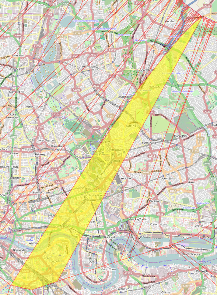
Diamond Geezer escaped from London by plotting the shortest distance (as the crow flies) from his home to the London boundary, and then taking the shortest walking route that gets to that same point on the boundary. He identified a pub in Woodford Green as the closest point on the boundary from a nominal start location at the Bow Roundabout in east London. A great example of experimental travel.

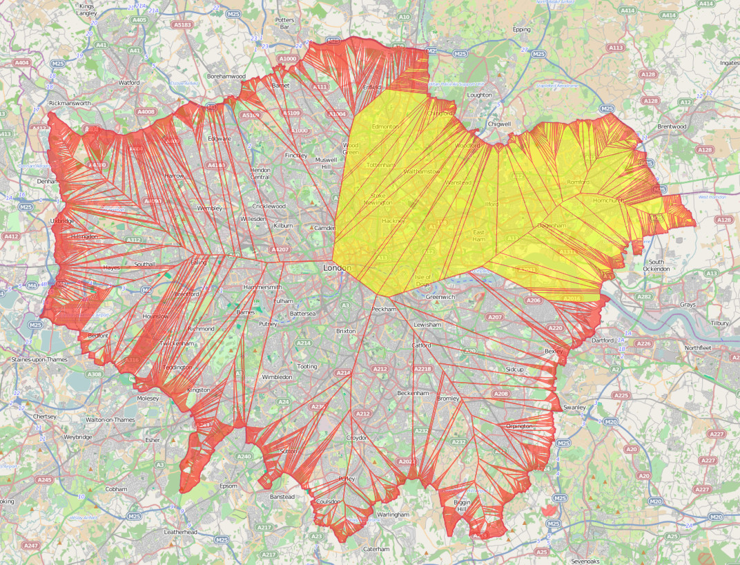
Being an occasional spatial analyst I wondered if there was a way to do the first step – identifying the closest point to me that is outside of London – using a GIS. In so doing I identified that there are five key exit points to where a large portion of Londoners could “escape” to. Additionally, it’s a novel way of identifying the location of a north/south London line, an east/west London split, and a way of working out which home county is your closest. Most of these are obvious if you are in outer London (Zones 3+), but are not so apparent if you are an inner-city dweller. The map above shows the parts of London where The Only Way Is Essex if you are looking for the shortest route out as the crow flies. This includes, somewhat surprisingly, the northern corner of Burgess Park, on the Old Kent Road in what most people would consider south London.

It turns out it is relatively straightforward to produce such a map – however with the important simplification that it is necessary to treat the boundary as a series of points, rather than as a border “line”, to avoid the problem with huge numbers of very small areas when increasingly close to the line. I used QGIS to create the resulting map, shown above. To create the map, follow the steps at the bottom of this post.

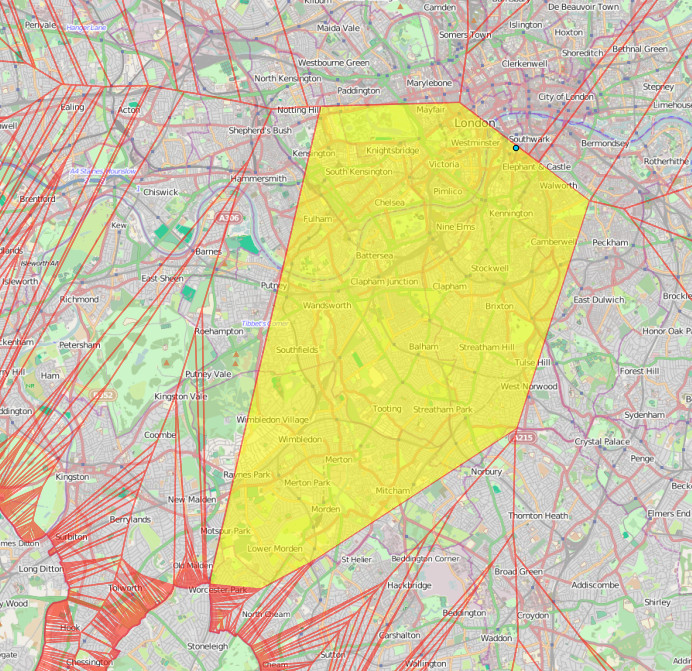
The bit of London’s border which has the largest part of London as its go-to point, shown on the map below, is just behind The Midas Touch pub, just south of Worcester Park station. This is the closest point on the London border for a huge area, including such places as diverse as Hyde Park, Kensington and Elephant & Castle.

leavelondon_biggest

The blue dot near Waterloo in the map above, by the way, is the geographical centre, or “centroid“, of London.

So did DG head to the right place? Nearly. The exit point is on Manor Road, by Woodfood Green, just a short walk from the aforementioned Woodford Green pub:

leavelondon_dg

& those five exit points most useful to Londoners? The places on the edge of London that are the nearest such place for the the five largest single polygons on the map. They are:

  • Just behind the aforementioned Midas Touch pub near Worcester Park station.
  • The junction of footpaths just beyond the end of Courtwood Lane, in Forestdale. Near Tramlink’s Gravel Hill station.
  • A track just inside the northern edge of Joydens Wood (the wood itself, not the village). Not far from Bexley.
  • The far end of the first road loop in Elstree Park, just off the Stirling Corner roundabout.
  • The middle of the woodland behind Monken Hadley Church of England Primary School.

So now you know.

Addendum: How to create the map yourself

You’ll need QGIS installed and to be familiar with how to use it to load layers, change settings etc.

Note: In many of these steps, the GIS operation requires the naming of a new Shapefile that is created, which should then be added to the list of loaded layers (aka Table of Contents) for the next operation.

  1. Add http://mapit.mysociety.org/area/2247.geojson as a new layer. This loads in the London (strictly, Greater London Authority plus City of London) boundary.
  2. Save this layer as a Shapefile, with CRS set to British National Grid, aka ESPG:27700, and add it back in to the project. The specification of British National Grid is necessary to ensure that “proper” square metres are used in the distance calculations.
  3. Set the project to allow on-the-fly reprojection, and set its coordinate reference system to British National Grid, also.
  4. Choose “Extract nodes” from the Geometry Tools submenu in the Vector menu. Because the London boundary is sufficiently complex, there is generally at least one point at least every 100m along the boundary. Optional: You can simplify the boundary before this step, for example if simplifying to 20m accuracy, this will drop the number of points generated from around 10000 to around 1000, although the resulting final map will look a little different.
  5. Choose “Voroni polygons” from the Geometry Tools submenu in the Vector menu.
  6. Choose “Clip” from the Geoprocessing Tools submenu in the Vector menu. You need to clip your newly created Voroni polygons layer to the original boundary polygon that was loaded in in the first step. This step will take a few minutes if you didn’t simplify the boundary.
  7. Add in an OpenStreetMap background. This can be done by installing the OpenLayers plugin, then using the plugin’s menu and adding an OpenStreetMap layer. You normally need to pan (or zoom) the map a bit for it to first load in. Note also this step will reproject the map to “WebMercator” which is similar to, but not the same as, British National Grid – sufficient for display purposes however.
  8. Reorder the layer list so that the OpenStreetMap layer is at the bottom.
  9. Remove all the other layers except for your newly clipped Voroni polygons and the OpenStreetMap background.
  10. Adjust the styling of the Voroni layer, so that the polygons are semi-transparent.
Categories
Leisure Olympic Park OpenStreetMap

Olympic Park Rising

7629386754_86db110501

The Olympic Park in east London was a flurry of colour and activity during a few weeks in summer 2012, but since then it has been largely locked away – a parcel of land opened last year, but with a security fence, access only from certain points and at certain hours, it hasn’t really felt like a proper park. A few cycleways have also appeared, but considering the “blank slate” of the area, they are laughably awful. Tradtionally the excuse for London’s poor standard of cycle tracks is that the roads are too narrow to fit them in, or there’s too much traffic to close a lane for cyclists. Both of these are rubbish reasons for many of our streets of course, but the lack of positive and effective action (apart from in a few isolated places) has allowed places like New York to leap-frog London as cycle friendly cities – during Autumn, more people used the bike-sharing system in New York than in London. I really hope it’s not too late to fix these mistakes.

The good news is that a lot more of the park is due to open very soon. The Aquatic Centre and the Velodrome are due to open in March, along with the outside BMX, mountain bike and road tracks. I’m rather disappointed that we’ll have to pay to use the latter, I had originally envisaged all the bridges being open to the public at all times, but with two of the bridges are forming the circuit, this will represent quite a large part of the park that is fenced off. I appreciate the venue buildings need to be self-sustaining in funding but it’s a shame that the outdoor as well as the indoor circuits are pay-to-play.

Then in April the south of the park reopens, and the Orbit. The orbit will, I’m sure, be about as popular as the cable car, at least until the view improves, but with the southern part of the park opening up, finally there will be a large, green(-ish) space which just might start to feel like a proper London park.

olympicpark_jan2014

One thing that is going to need updating is the map. The official one is really not that great (What do the dashes mean? What do the dots mean? Why are the open areas outside the park shown in the same grey as closed areas inside the park?) so we’ll have to turn to the crowdsourced map of choice, OpenStreetMap. This map (above) isn’t looking great at all either at the moment – some features that were around only in 2012, such as the athlete’s access tunnel across the Greenway, are still on there. Red dashes show out of bounds paths – how many of these will come in bounds in March/April? So we’ll need a Mapping Party some time there in April/May, and after that, the map should look pretty good.

The park was great for a few weeks in 2012, but the slow pace of opening, and the efforts so far, have been disappointing. But despite my grumbles above I’m greatly looking forward to the park opening, them sorting out the cycle lanes and access, and it maybe becoming, one day, a great space for cycling through, jogging in, or maybe even a bit of park orienteering?

Map © OpenStreetMap & contributors.

Categories
Conferences

Globe

globe

I’m now the proud owner of this lovely green glass globe paperweight – it was my prize from the web map category of the mapping competition at the FOSS4G conference last year, but it’s taken me this long to finally get my hands on it, as I was disappearing on a train before the end of the conference, and accidentally delegated receipt of the prize to a friend who I thought lived in London – actually he lives several hundred miles away. Anyway, thanks to the organisers for coming up with such an inspired prize, one that is useful and beautiful.

Categories
BODMAS London

London Tube Stats

londontubestats

London Tube Stats maps data about how the London Underground is used – how many people use each station at various times of the day, and where they go once they are on the tube.

Transport for London, the city’s public transport authority, have a huge amount of data available in their Developers’ Area website, much of which is regularly updated. I’ve used the bike sharing system data fairly regularly, however I’m keen to take advantage some of their other datasets.

Back in 2010 I built a map mashup of the entries/exits data that, at the time, TfL made available on a (now defunct) performance website. The mashup consisted of varying the sizes of circles over each station, to represent how many people entered/exited the station, at certain times of the day, days of the week, or years, depending on the options selected. I wrote about the mashup here and also mentioned an update when the 2009 data was released, but the site languished. TfL changed the way that the data is formatted as it was moved across to the developer website, so adding future years wasn’t going to be straightforward, and also I never liked the rather stark black and white background map, with the tube lines “baked in” to it, and including various tube depots and other running lines that weren’t part of the passenger network, that I had created quickly.

londontubestats_keySo, I’ve rewritten the mashup from scratch. The main view shows the entry/exit data, by time of day, for 2003-2012. Choosing an option from the drop-down menu at the top will vary the circle sizes, the area of each circle representing the numbers. Clicking on a station will reveal a table of the underlying numbers, with colours showing trends. Then there is an additional view that uses the TfL RODS (Rolling Origin Destination Survey) data for 2012, to show journeys. RODS is based on surveyed data that is then scaled up to match the recorded entries/exits from the barriers, and the numbers represent a typical day. Click on a station to mark the place people enter the system, the other stations then shift in size to show where people exit. You can change between the two datasets using the Metric drop-down menu.

The background map is based on OpenStreetMap data, and the station locations and coloured tube lines are also based on this data – but I’ve tweaked it to show just one line per service, rather then individual tracks and depots.

Gist on GitHub

As part of creating this map, I’ve released the first in what I hope will be an increasingly large set of CASA open data releases. The release, as a Gist on GitHub, is of two files, in GeoJSON format – one for the tube lines, and one for the stations. The files also contain routes and stations for Overground, DLR, Tramlink, Emirates Airline and Crossrail (which starts in 2018) services. These are hidden from the London Tube Stats map, as stats are not available for these at the moment, although you can see them by setting all three dropdowns to the blank option.

I particularly like that GitHub spots that the files are GeoJSON, and effortlessly displays them as a map, rather than presenting the underlying JSON data by default.

[Update 1I’ve tweaked some colours – I now am using yellow vs blue when showing entries and exits for the journey metric. I’ve also added a new metric which compares the ratio of entries vs exits for the AM Peak numbers. Choosing the journey metric now always defaults to showing a selected starting station – currently Finchley Road. Click another station to show the stats.]

Categories
London

The Flat Tyre Tube Map

flattyretubemap

Ever been stuck with a bicycle with a flat tyre, in London but far from home? This has happened to me, many times, including twice in the last week, thanks to the usual combination of rain, grime and broken glass that seems to be endemic at this time of year here. & I don’t generally carry a spare inner tube, tyre levers and mini-pump.

Normally, I’m just aiming to get the bike home, where the toolset awaits, but how to do that? Full-size bikes are not allowed on buses, Tramlink, or “deep level” (i.e. bored) sections of tube lines – and until recently they weren’t allowed on the DLR either. TfL have this useful map showing where you can take them on their network, but this doesn’t include “heavy” rail lines which are generally more accommodating. Here is an equivalent map, but for First Capital Connect trains only.

So, I’ve modified the combined Rail & Tube Map to get the best of both worlds, and be sure of getting my bike home. Because I’m always looking for the cheapest way to complete such a recovery journey, I’ve included the Zone 1 area, as a place to try and avoid if possible. The orange-coloured London Overground lines then become very useful. I’ve also included, as red dots, a number of the “out-of-station interchanges” which aren’t normally shown on tube or rail maps, but which allow a by-street transfer between lines while counting as the same Oyster card journey. These make, for example, the GOBLIN (Gospel Oak to Barking LINe) a lot more useful, should you find yourself with a broken bike in north or east London, adding six valid connections which are otherwise unmarked on the main maps.

Most striking is the “hole” in central London, only one line passing through the Circle Line’s main loop. The Victoria and Waterloo & City lines are completely gone. A few less useful tube line sections are scattered to the north – I can’t imagine many people have ever taken a bike on a train from Cockfosters to Oakwood, for example. Your Oyster card also won’t get you to Heathrow with a bike – but then you presumably don’t live there anyway. The Central Line terminates just short of Stratford, which is annoying if you are trying to get back from Epping – but an out-of-station interchange at Leytonstone means there is a viable connection after all.

I “fiddled” with the original map in Illustrator – first deleting the banned sections, then rearranging station blobs so that they were connecting with blank space. It should be noted also that, if you end up with a flat tyre and are planning the tube method of recovery, that full-size bikes are banned from pretty much the whole tube network, and most of the rail network, during the weekday rush-hours.

This is a strictly unofficial mashup/modification of the original map which was produced by, and is the copyright of, Transport for London and ATOC. Here is a larger version.

[Update 1: Have added the Dalston OSI as multiple people have asked for it!]

Categories
Technical

This Blog has Moved!

The blog is now at https://oobrien.com/. The old oliverobrien.co.uk domain will continue to work for a couple of weeks. My leisure blog has also moved and is now at /.

Why? I’m consolidating the number of domains I own, to make management easier.

Categories
Leisure

San Francisco

IMG_1296ec

So… I went on a holiday last month to San Francisco. I’d been planning on a return to the west coast of America since a trip to Vancouver for a conference in summer 2012, and San Francisco is one of those places I’d seen a lot about but never actually visited. The excuse to finally make a visit was the combination of (1) a series of orienteering sprint events – Sprint the Golden Gate (2) cheap-ish flights – £525 return, and (3) various friends from school and university who have made it over there on a semi-permanent basis.

As December approached, the orienteering series was looking a bit shaky – permit problems, which I can strongly relate to with the inevitable permissions headaches that arise year on year with the London City Race. But I went ahead and entered. US orienteering races are extremely expensive to enter compared with the UK/Europe, due to insurance and expensive park permits needing to be included, but conversely the GBP/USD exchange rate has shifted quite a bit recently, making the US a cheaper place to visit than historically.

I arranged to crash on the floor of a friend’s apartment in the Marina District, and to meet up with four others who I knew were probably nearby. I had the Lonely Planet guidebook but the plan wasn’t to look at it that much! As is reasonable for a city of such beauty, I took a lot of photos (400+) and the best 70 are linked in the text below, and can be viewed on one page on Flickr.

Tuesday – Arriving

The flight over was OK, although the route was intriguing – going very far north, further than I thought we would, so that we were quickly into the Arctic Circle and, as happens at this time of year, even though it was the middle of the day, it got pretty dark outside. To possible take advantage of the unusually strong jetstream, which has been plaguing the UK with storms for the last month, we actually “overshot” the west coast of North America and headed right over Vancouver, before heading south-east to San Francisco itself.

I had a few hours before my friend appeared from work, so I got the BART into downtown, picked up a T-Mobile $3/day SIM, accidentally walked straight past the famous Apple Store and a bikeshare docking station, and wandered down to the Ferry Building, from where there is a great view of the Bay Bridge which currently has an evening lightshow. I then did a long, gradual walk anti-clockwise along Embarcadero, first heading past the new location of the Exploratorium and some outdoor exhibits, and then to Pier 39, a slightly kitsch but popular food/gift arcade. Taking a side-route out, I completely unexpectedly came straight across the sealion colony, which was making an amazing racket. Apparently they’ve been there pretty much since the pier was built. Checking the map, Russia Hill sounded like an interesting name, so I headed south, eventually making it to the hill up some impressively steep roads and flights of steps. I then headed over to the famous squiggly bit of Lombard and then a long walk along Chestnut down to the Marina District.

Wednesday – Walking

This was the big walk day – I walked 18 miles in the end. From the Marina District I headed north to the marina itself, to visit the Wave Organ sculpture there – with great views of Alcatraz Island and the Golden Gate Bridge – we’ve all seen a thousand images of it but there is no substitute for the thrill of seeing the most famous bridge in the world for the first time in real life. I then walked around the park at the pseudo-Greco-Roman Palace of Fine Arts, and then back to the shoreline, through Crissy Field and to the Golden Gate Bridge itself – the way on to the bridge wasn’t immediately obvious so I overshot a bit at first, and ended up under the bridge at Fort Point. After various tourist pics from and of the bridge, I headed off the far end of the bridge into Marin County. The walking route north doesn’t go much further (no pavement) so I had to get a bus from here to Sausalito, where I had half an hour to wander around – little to see though – before getting the ferry back to San Francisco. The ferry takes a great route, passing nearby Alcatraz Island, and with a symmetrical view of the Bay Bridge, before ending appropriately at the Ferry Building.

IMG_1348e

After grabbing lunch at some boutique stalls in the Ferry Building (think Borough Market but even fancier) I walked down Market to the famous cable car turnaround at Powell. After the inevitable wait in the tourist queue, watching cars getting rotated, I got a cable car over to Hyde and Bay, before walking back up Hyde – very steep – and down the wiggly bit of Lombard again. Then along Lombard to Telegraph Hill and the Coit Tower (closed) for a 360-degree sunset view. Down the wrong set of steps to Levi Plaza, back up the right set, down again to Downtown, around the Transamerica Pyramid, the Bank of America plaza & tree, and Union Square with its Christmas tree and Macy’s. Then a loop up to and around Chinatown and Dragon Gate, and a long walk along Geary, through Tenderloin (a starkly downtrodden area), to Japantown with its concrete pagoda and a pocket park. More hills found on the way back to the Marina District!

Thursday – Silicon Valley

First, a slow bus through rush hour, right across San Francisco to the Caltrain terminal. I made my connection with a minute to spare and got the huge and impressive Caltrain “Baby Bullet” double-decker train service down to Palo Alto. I then spent an hour walking to and around Stanford’s otherworldly university campus – including longer than planned in the unexpectedly massive Stanford team shop – before walking back to Palo Alto to get a lift to the Facebook HQ for a quick tour and lunch with a friend from university. Then an hour’s walk through American suburbia all the way back to Palo Alto station.

The original plan was to visit a friend at the Googleplex, but this didn’t work out, so I got a couple of buses instead over to the Computer History Museum. Highlights for me were an original Cray 1 Supercomputer (the circular black casing with “seats” still looks very cool) and an Apple I in a wooden case, signed “Woz”. Finally another long walk through Mountain View surburbia – Silicon Valley railway stations being sparse – and the Caltrain back into San Francisco. Signage is poor around the Caltrain terminal – I somehow ended up in front of the SF Giants stadium why trying to find my bus stop back. The bus gradually filled up with homeless people – it was a very cold evening, almost freezing, which is unusual for San Francisco – despite the best attempts of the bus driver: “you can’t go round and round for ever!”. It was a short walk up into Cow Hollow for an evening meal.

Friday – West

Another long-ish walk, this time south from Cow Hollow, first steeply uphill to Broadway, then to Alta Vista Park, then Alamo Park, and then the Lower Haight. I had lunch here at a cool Shoreditch-style coffee shop, but somehow missed out the more famous Upper Haight, by following the “Wiggle” cycle route to and through Panhandle Park. I cheated a bit here – Golden Gate Park and Upper Richmond go on a long way, so got a bus down to Ocean View and walked along the beach beside the Pacific, as the only clouds of the week gathered offshore. To Land’s End and the first orienteering sprint of the week, a short, but hilly forest sprint with a great multi-level ladders-and-platforms section in an old water facility. Then, a long journey from the far western tip of San Francisco, right over to Berkeley, to meet up with a schoolfriend. I didn’t see any of the university, or indeed much of Berkeley itself, as it was pouring with rain.

Saturday – Sprints

Three more orienteering forest sprints today. First, a couple in the middle part of Golden Gate Park, near the polo pitch. We were seeded and then started in groups. A warm down jog around the polo pitch’s perimeter track was 1.3km for a single lap! Then lunch in Irving – the second Chinatown of San Francisco, and then a long and slow bus right over to John MacLaren Park at the other end of the city for a final afternoon sprint. I struggled in the hilly terrain. Evening was a more formal dinner in the Mission District.

Sunday – Final Day

An early start to get to one last orienteering race – at San Francisco State University. A long way from the Marina District but thankfully a direct bus there, on a spectacular route – almost going across the Golden Gate Bridge, but turning at the last minute onto the Presidio, through Golden Gate Park and down 19th Street. The was the only campus sprint of the series and, though the area was small and limited, a good course was got out of it.

Afterwards I headed up through Stonestown to Forest Hill and Twin Peaks. Perhaps the most iconic view in the whole city from here. Then I headed north through tiny Tank Hill Park, to the edge of Golden Gate Park to the California Academy of Sciences which was having a free day (normally $25). It was, predictably, very busy, and the queues were too long for the earthquake experience, the tropical biome and the planetarium, so I only made it to the aquarium and the “Tellytubbies” garden roof, plus a rather underwhelming pen with a couple of reindeer and, randomly, some live penguins in a hall of stuffed animals. The CAS is an odd place really, the name is a bit of a misnomer, and the equivalents in London – the Science Museum, the Natural History Museum and the Horniman Museum’s aquarium, better combine the academic, educational, cultural and fun aspects of a good museum, while the CAS is only really strong on the large part. But I think we are a bit spoilt by our great museums here in London.

Finally, the journey home. A bus back to the Marina District, then another bus, then I just had time for another Cable Car journey back, from Hyde and Bay, to Powell. Then it was the BART to the airport and the inevitable jetlag to hit two days later…

An beautiful, exciting city with something interesting over every summit – I had a real sense of regret on leaving, knowing that life is just better here than back at home! I missed out on quite a few things to see that were on my internal list – the Exploratorium, the De Young Museum, Berkley University, the Googleplex in Mountain View, San Jose, the Cable Car Museum, Fisherman’s Wharf, the fog, the viewpoint NW of the Golden Gate Bridge, cycling, Muir Woods and of course Alcatraz.

Golden Gate Lighting Post (1291)Greenland Mountains in Ice (5194)The Apple Store (5206)Bay Area Bike Share (5207)Bay Bridge Light Installation (5209)Christmas Tree at Pier 39 (5214)
Do Not Drive on Tracks (5219)Citizen Chain (5220)Wave Organ (1215)Alcatraz Island (1218)Wave Organ Detail (1223)Palace of Fine Arts from Baker (1233)
Palace of Fine Arts Interior (1246)Walk with a View (1252)Dogs and the Bridge (1258)The Golden Gate Bridge (1261)Bike Highway leading up to the Bridge (1265)No U Turn (1269)
Map of Bridge on Bridge (1271)San Francisco from the Golden Gate Bridge (1277)No Trespassing (1278)Golden Gate Bridge Cables (1284)Rivets in Red (1287)Golden Gate Lighting Post (1296)

San Francisco, December 2013, a set on Flickr.