Categories
Conferences OpenStreetMap

State of the Map

I’m off to the State of the Map conference in Amsterdam on Friday. It will be interesting to compare with the OSGIS UK conference a couple of weeks ago.

I almost certainly won’t be live-blogging the event, thanks to data-roaming charges, but if I get around to setting it up, there might be a few text-message-powered short entries.

The schedule is full to bursting, with two parallel streams of talks and a workshop stream. I should, if all goes to plan, be giving a “lightning talk” on how we are using OpenStreetMap data here at UCL, in particular as a “context layer” for laying on choropleth maps. However, there are a lot of lightning talks and only a limited time in the schedule for them, so we shall see. Certainly looking forward to hearing about Steve8’s crowd-funded mapping expedition to Antigua last month! In the “main talks”:

  • Muki Haklay’s talk about quality should be interesting. OSM certainly has “quantity” now, with the ever-increasing numbers of crowd-mappers, thinking about how we measure and display the accuracy and completeness of data is something that is going to become more and more important.
  • Being a closet cartography enthusiast myself, Matt Millar’s stylesheet talk, and Andy Allan’s advanced cartography talk, will be of particular interest.
  • Sunday’s “secret geo-celebrity” keynote soudns intriguing.
  • Peter Miller’s talk “The Good, the Bad and the Ugly”. Hmm!
  • Laura Slivinski’s TerpNav (OSM for pedestrianised areas.)
  • Vladimir Agafonkin’s Online map visualisations made easy – viz is always a crowd-pleaser and the IT-orientated community behind OSM is capable of some great off-the-wall viz thinking thanks to coming from a “different” background than the traditional geographers.
Categories
Leisure Orienteering Events Log

Dunwich Dynamo 2009

img_0389
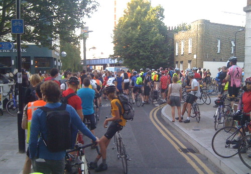
This is an annual 180km self-supported ride from London Fields in Hackney, to the beach at Dunwich in Suffolk. As it’s a free turn-up-and-go event, it’s all quite informal – people just turn up at the Pub in the Park and then start to head off. The catch – it’s a night time event. I started at 8:50pm…

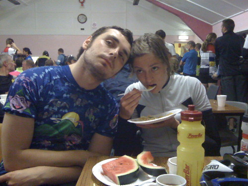
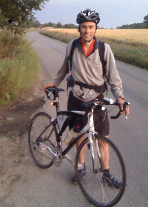
I was riding with Jenn and Michal, also trying out various new accessories I’d bought in the day – a fell-runners’ bag, saddle bag, frame bag, padded shorts, a proper cycling top, cleats and a couple of bike lights (which proved to be woefully underpowered.)

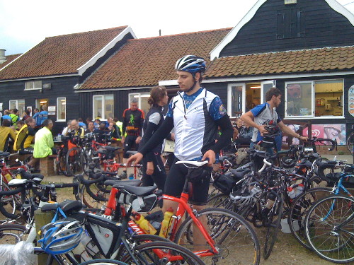
There most have been close to a thousand cyclists in this year’s Dynamo, taking advantage of the calm, dry and clear weather, although it got surprisingly chilly quite quickly.

The pace was far faster than I was expecting – once we had passed the highest point of the route (Epping Forest) the pace really went up and we pushed hard until the food stop at 100km, arriving at around 1:15am. The pace then on was also quite fast, at one point a wonderful 10km with the Dulwich cycling club peloton. Then, as dawn broke properly, we started to tire a lot.

img_0395

We finally made it to Dunwich at 6:10am (ride time 7h 23, + 2 hours of breaks) where the cooked breakfast in the cafe was very welcome – the rain shower, the first of the night, wasn’t. We took a risk, cycling 8km through the second rain shower to get the first local train of the day. 20 others had the same idea, but the guard let us on, and three hours later we were back in London. An extra 50km to cycle to Ipswich for the main-line trains was thanfully avoided.

img_0404The high point was tearing down the Suffolk Coastal District part in the back of a fast-moving (~35km/h) peloton. The low point was definitely waiting for the rain to clear at Dunwich and dreading the cycle to Ipswich. The most memorable sight was seeing a long stream of flashing red lights in front of me, sweeping around invisible corners.

Despite the pain near the end, it was great fun and good training for when I set off to cycle the length of Britain (Thurso to London) in a couple of weeks time.

We spent a couple of hours taking breaks, including nearly an hour at the 100km feed station. The first 100km was virtually without stopping, but the latter section had more frequent stops, as Michal’s bike started to make strange mechanical sounds and so he limited his speed. We also took a couple of wrong turns later on, although we found straightforward shortcuts back onto the main route. At one point, Michal and I thought Jenn, who was generally the fastest of us three and was ahead most of the time, had missed a sharp turn and headed off to the coast 10km south of Dunwich. However, after a bit of worrying, it turned out she had made the turn after all.

On the back of a disturbed night the night before, and obviously no sleep at all last night, I don’t feel too bad right now. However I did nod off numerous times on the packed train back from Ipswich to London.

Drinks-wise I got through 1 litre of Lucozade and around 1 litre of water, + coffee at the feed station and at the cafe at the end. Food I ate included some chewy sweets, three Power-bars and few Clif Shot Bloks. At the half-way point a had a pasta salad plate and a couple of bananas. At the end I had an SIS sport bar and a Clif bar, as well as the cooked breakfast. As a consequence I didn’t bonk at all and feel fine now!

[osm_map lat=”51.886″ long=”0.779″ zoom=”8″ width=”500″ height=”350″ gpx_file=”/files/2009/07/04-jul-09-20_53.gpx”]

img_0407

Categories
OpenStreetMap Orienteering

The COMO Project and Seek ‘n Spell

Michael (of the Okansas blog) has recently mentioned two quite interesting orienteering-related ideas:

1. The COMO project, which is looking to use OpenStreetMap data to create orienteering maps. This is very similar to (although more advanced than) my own work – I looked at creating Street-O orienteering maps from OpenStreetMap data for my dissertation for my MSc in GIS last summer, and additionally built an Osmarender-generated/OpenLayers-based based map for viewing and printing such maps easily – although I never got around to releasing it publically. I’ve subsequently thought of extending the process for “proper” orienteering maps, while keeping the data in the OSM database. The COMO project is looking at creating “proper” orienteering maps, converting OCAD data into a form which can be read into a special database separate from the main OSM one.

As an aside, it would probably be easier not using the OSM flow or API, but rather a PostGIS database to store the data, with GIS applications such as Quantum GIS to do the editing. Mapnik as the rendering engine is considerably easier to set up, configure and use than Osmarender, too.

2. Seek ‘n Spell, which is an iPhone game, uses the internal GPS, the ability to broadcast your location to a central server, and aerial photographs, to create multi-player games where you can run around, collecting letters to spell words. See Michael’s post and also the video – the action looks uncannily like a combination between SLOW’s Mobile-O and a “normal” mass-start score orienteering event. The game-view reminds me of watching an animation of a race in Routegadget. The concept and the finish quality of the app looks great but the name is a dreadful pun – hopefully they’ll rename it something a bit snappier.

Categories
Uncategorized

Two Weeks

…until I step on a series of trains up to the far north of Scotland, before cycling back home. If all goes to plan, I should be back in London 11 days later, after 9 days of cycling, a day of travelling and a prologue.

Training has been going reasonably well, with a series of day rides radiating out of London, to Oxford, Brighton, Eastbourne, Rye and Canterbury, as well as an unplanned ascent of Leith Hill. The Kent hills are typically small, but numerous and steep – perhaps not the best practice for the longer, but generally gentler hills in Scotland.

It has been exceptionally hot here in London over the last few days. It isn’t forecast to stay this way, but I hope that we will get some sunshine in Scotland, and that we can cycle faster than the midges can fly! Nine days of rain would be a great shame. The long-range forecasts at the moment are unclear.

I would love to be able to push my location live to a map on this blog, but the iPhone can’t do this (unless I had an application open all the time, which would quickly eat the battery.) So I’ll probably aim just to stick up a blog post each day.

I should pass Gregory cycling in the other direction, somewhere just north of Inverness on the 19th.

Categories
Mashups OpenStreetMap

Map of UK Scenicness… and Pubs

picture-5

Here’s a little something [no longer online] I knocked up, based on the MySociety scenic score data release last week, as well as OpenStreetMap’s data for the UK – including particularly its pubs.

Basically, the vote point data was converted to a surface, using an IDW (Inverse-Distance Weighted) function. The cell size was pretty small (1km), so there isn’t much smoothing across many vote locations going on – a single vote may cause quite a steep gradient. Instead, the surface effectively extrapolates the values into all areas. Some jiggery-pokery was required to first project the votes onto the British National Grid (so that x/y distances become equivalent) and then the resulting surface was fully rasterised and reprojected to Spherical Mercator so that it could be tiled under the existing OpenStreetMap network overlay. This was surprisingly painful to do.

Note that the photographs that were voted on generally weren’t of the pubs shown on the map, so the pub might well be extremely photogenic – but in an area where the nearest Geograph photos used in the dataset for the voting were not rated highly.

It’s good to see that the Scottish Highlands come out so green (i.e. scenic.) Urban areas generally don’t do too well, although the voting was generally quite critical, so a yellowish hue is still a sign of a very scenic part of a city.

Data came from MySociety (using photographs from Geograph) and OpenStreetMap. The pub icon came from Wikimedia. The map tiles were produced using Mapnik for the OSM network overlay and MapTiler for the scenic map. The increasingly excellent OpenLayers is used to display the tiles, and a point vector layer showing the pubs.

There’s many areas with apparently no pubs at all. This is simply because the data wasn’t in OpenStreetMap when I pulled it in on Friday. However OpenStreetMap’s data is rapidly becoming more complete throughout the UK at the moment, so a future pull of the data should reveal many more pubs.

Some very remote areas don’t have any vote data either, but the production of the surface uses and extrapolates the values from nearby votes instead.

scotland