 So, the fourth City of London Race happened at the weekend. 1109 people crossed the start line, and with around 80 helpers from South London Orienteers, almost all dressed in the distinctive red City Race helpers tees and hoodies, the event went off pretty smoothly. No controls were vandalised this year, even though we had almost 80 out on the course, and although there were a couple of mistakes on the map (including at a key section in the Barbican), and a normally-locked gate that a number of people discovered open (and ran through), no competitors raised formal complaints. Feedback on Nopesport, Attackpoint and Twitter has been generally very positive. St Giles Terrace and the City of London School for Girls proved to be a brilliant race arena. It was big enough to accommodate everyone, scenic (with the old church, the lake, and a glimpse of the Gherkin if you knew where to look) and visible to the public, some of whom had a go at a course on the day. I don’t think the flats overlooking the arena were unduly disturbed by the noise – it turns out that once the fountains in the lake switch on in the morning, everything else is drowned out.
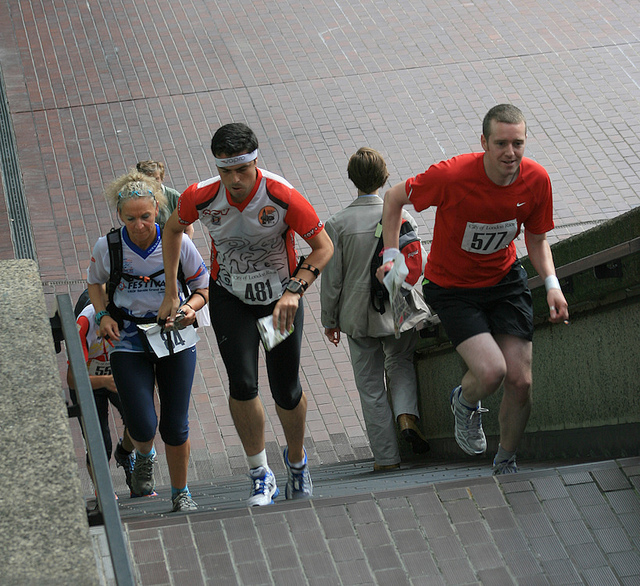
During the event, I was able to spend most of my time out in the Barbican Estate itself, taking numerous photographs of runners at various levels and angles – you can see 156 of the best here. I only needed a few urgent trips out on the bike – to rehang a control higher, hang two in a park that only opened just before the event start, and tape off an illegal approach to a control hung by a (low) uncrossable wall. Other developing issues, such as a poorly mapped set of stairs confusing some people, were left unchanged so as not to make it even more unfair for the early runners.
 We know some people ran out of bounds (N.B. The person in the photo here is in-bounds!) – through the aforementioned locked gate for instance, and one person with a headcam filmed himself running into the Barbican centre, up a couple of internal stairwells and back out onto the map. There were other similar quirks, and also roadworks that disappeared in the few days before the event, while several others sprang up. Crossrail’s and Thameslink’s impact on the City should not be underestimated, and hoarding lines seem to change on an almost daily basis. The City also itself is carrying out many “Streetscene” enhancements, gradually pedestrianising and beautifying areas, the skyscraper builders are hard at work anticipating the next boom, and Thames Water is desperate to find all those leaks. It’s not my final call, but I don’t think we are disqualifying anyone – it’s not a Championship, we don’t think these wrinkles materially affected the results enough (the notorious gate saved people at most 40m and a couple of turns), and it’s part of what makes it an urban race, rather than a sprint or a regular orienteering event where the land is more static and reliable. I’m sure that gate will be taped in future years though…
 We had great difficulty accommodating the 209-odd starters on the Men’s Long course – fewer than expected opted for Men’s Short on entering. Maybe a Men’s Elite (with a hard limit of say 90, at two minute intervals, and entry by invitation from the Men’s Long start list) would be the way to go. At the same time, I dislike having a Men’s Short with a prize for the winner. People are in fact allowed to enter any course at non-Championship events like this, and many people treat Men’s Short as a course to run if they are injured, want an easy run, or consider themselves to be “not competitive” rather than as a genuine competitive course. This is why the Men’s Short course had two people who finished well ahead of the rest, and who have scored far more points than indeed the winner of the Men’s Long. So maybe an invited Men’s Elite and general Men’s Open should be the split for future years.
The event organising team is, I think, now suffering somewhat from volunteer fatigue. I know that the time spent on the event by many in SLOW (the organising club) was great – probably too great. In my case, the great majority of the time was spent on the “labour-of-love” work of extending, updating and correcting the map that I have nurtured now for over four years, exploring the new parts of the City, test-running, and running the event’s website – including a “live page” on the day that I was able to post photos to, and gather tweets from others. Only the last-minute worrying and what-if-ing of the final two weeks was the bit I would rather avoid! The traditional organising truimviate of planner, organiser and controller also spent more time than they normally would on a “bog-standard orienteering event”. It was a lot of time, but the result was a polished event – I thought the planner’s courses this year were the best yet, even the very first leg had three possible routes and an immediate decision to be taken by most competitors.
 It will also be interesting seeing what happens to the event, now that it is the biggest urban orienteering race in the UK, and quite possibly the second biggest in the world after Venice. Certainly, the 300-odd overseas competitors gave the event a lovely international feel – particularly as the overseas designs of orienteering tops generally look a lot better. I have already written my thoughts on what could happen to urban orienteering in London in general. Clearly there is a certain expectation amongst both the local orienteering community and the o-tourist, for future “city style” events, where the typical run is for an hour and the route, while not necessarily being very technical, passes several of the “London landmarks” – this year St Paul’s Cathedral, the Gherkin, Lloyds of London and of course the Barbican were visited by many. But at the same time I think the format needs to be tweaked and refined to keep it fresh. Certainly we have overused the Barbican Estate now – it was used a lot in 2008 and a bit in 2009, and a huge amount this year – so I expect that this will play almost no part in races for the next few years – not least because of impact on the residents and the difficulty of negotiating access. With next year’s pairing with the Southern Championships in nearby Epping Forest the following day, perhaps there is a case for having shorter courses with target winning times of say 35 minutes – i.e. a “middle-distance” urban race which, due to the higher pace and shorter legs, would also allow less technical areas to be enjoyed more. There is also perhaps less pressure on keeping the race “technical” anyway, as the following day’s event should satisfy in that regard.
Now, back to the regular orienteering – Street-Os in London, “real” orienteering outside such as the CompassSport Cup Final and a Mountain Marathon, and enjoying the efforts of other urban race organisers – Cambridge in October should be a real treat with the college quadrangles, and I might even make it back to the granddaddy of urban racing – Venice.
See also the report from Brooner, the co-founder of the City of London Race.

 NY will doubtless be looking to London closely, as it probably is the scheme most similar to New York’s – the same technology, roughly the same size and area (all of the US and Canada’s schemes are much smaller) and London’s topography is also quite similar – a major river bisecting the scheme, a single major business district (although London will cover two with next year’s extension to Canary Wharf) with a separate commercial centre, and a very large public park. Doubtless NY will see huge popularity for the bikes in Central Park on weekends, as London does in Hyde Park, and a big morning “commuter surge” from Brooklyn into Lower Manhattan, just like London’s from the Waterloo area to the City.


