I worked for four years (from July 2010 to August 2014) as a researcher/software developer at CASA, a multi-disciplinary research & development (R&D) lab at UCL, where I had flexibility and resource to be able to produce all kinds of geographic visualisations, many of which are listed below. Some even still work!
Bike Share Map: 2010
A novel way of mapping the live docking-station information for bikeshare systems. Bike Share Map was born out of the combination of a General Election data map I had created earlier in the year, and the launch of the London bikeshare system, which had a data API and a not-so-great official map. I was lucky enough to win a EU Open Data competition prize in 2011 and travelled to Brussels to accept it.
GEMMA: 2011
GEMMA (Geospatial Engine for Mass Mapping Applications) was a 6-month JISCgeo project, working with Steven James Gray to create tools to collect, visualise and produce PDF maps from OSM data and other sources. GEMMA is no longer available online, as technology platforms have evolved, but there are some blogposts about it, here.
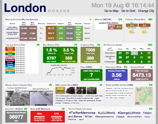
CityDashboard: 2012
A live, ticking, colour-changing visual data dashboard for London and other UK cities, collecting from various open and free sources and presented as a website. The principal output of a short NeISS/JISC-funded project at UCL CASA. It was created myself, with prototyping by Duncan Smith and some additional coding by Steven James Gray, Richard Milton and George MacKerron, all at UCL CASA.
- Summary of the project
- All my blogposts about CityDashboard
- CityDashboard (London, Other UK Cities, UCL Museums)
- API Documentation and API Update
- API Uses: London Periodic Table (info) (myself) plus a mockup version created as part of an entry to a competition at the ODI, London Data Table (myself & Steven James Gray), iPad Wall (Steven James Gray), Prism (more) (Keiichi Matsuda), PigeonSim
- Paper: Roumpani F, O’Brien O, Hudson-Smith A. Creating, visualizing and modelling the real-time city. Proceedings of Hybrid City II “Subtle rEvolutions” conference, May 2013. Online version.
- Selected Press: PSFK Wired The Guardian Londonist The DST Water Cooler Engaging Cities BBC News
The project is not being actively maintained or developed, but remains online for interest and for reference. The UCL Museums version came a little later and was funded by a UCL Beacon grant. CityDashboard was presented at a conference at UIC in Chicago in 2014.
Bike Share Map: 2012
I was lucky enough to receive follow-on funding to build out Bike Share Map to visualise hundreds of city bikeshare systems, around the world. I also produced video versions for the London Data Table and for an exhibition at the London Transport Museum, and attended and presented at the VeloCity conferences in Vancouver (2012) and Vienna (2013). The continuing popularity of Bike Share Map sparked my interest in shared micromobility which continues to this day.
EUNOIA: 2013
This was an EU project to catalogue and drive forward the use of microsimulation for Land Use Transport Models (LUTM), particularly MatSIM. My work involved gathering the history of the field to date, surveying LUTM users across Europe, and exploring the potential of MatSIM for traffic simulations in London, Zurich and other large cities. The project notably kicked-off in Majorca, with later meetings in Segovia and Brussels, and MatSIM training in Berlin.
DataShine: 2014
Following on from one of my pre-CASA projects to visualise the UK 2001 Census, this project flexibly and efficiently mapped outputs from the UK 2011 Census. It was part of the BODMAS (Big, Open Data: Mining & Synthesis) grant received by Professor James Cheshire.
The latter part of the DataShine project was carried out at UCL Geography, until 2015, when it became part of CDRC Maps, as part of the Consumer Data Research Centre, which I have worked at ever since.
Other CASA Web Projects (Online for Now)
- Sense & the City Oyster Cards Visualisation (2011)
- Rank Clocks
- London Periodic Table (mentioned above)
- Live Electricity Flows to/from/in Great Britain (2014)
- London’s Political Colour (2010, 2014)
- New datasets for London on MapTube (2010)
Other CASA Web Projects (Now Offline)
Although these are offline (due to legacy OpenLayers 2 code, using an old database, non-secure HTTP links or other expired dependancies), they normally have a blogpost here on oobrien.com with a screenshot.
- London Bus Route Map
- CASA Visitors Welcome Map
- OSM Compare (completeness vs OS Meridian roads) (2010)
- Lonely Buses (use bus stop data to find missing OSM roads)
- Scenic Photos Data Map
- Hubway (Boston Bikeshare) Journeys by Demographic Map
- Output Areas 2011 Map
- Output Area Classification (OAC) Versions Map
- Adjustable Heatmap of London Crime Locations by Type (2011)
- Heatmap of geolocated Twitter tweets in London
- Santander Cycles journey flows as a hint.fm/wind-style wind map
8 replies on “CASA”
We’re a group of volunteers and starting a new
scheje in our community. Your site provided us with useful info to paintings on. You’ve done an impressive process and our wjole community can be grateful to you.
Good to see both Glasgow & Edinburgh as options.
Hopefully you will consider developing a CityDashboard v2 in the near future.
Regards,
Alastair Majury
Hello. Amazing website (CityDashboard). Can I please ask if any other cities are expected to join the list, and can Bristol please be considered, if it’s not already? Many thanks. Pieers.
Hi Pieers – CityDashboard is not being actively developed at the moment.
We did consider Bristol – we can only have a limited number of cities featured easily, due to rate limits – so we picked nation capitals and cities associated with the project sponsors/funders. I certainly agree that Bristol is an interesting city with a large population and lots of data to visualise this, and should there be a CityDashboard v2 it is certainly one we should consider.
[…] (source: Suprageography) […]
[…] CityDashboard […]
[…] CityDashboard […]
I am working with a bunch of researchers, activists artists etc on a seminar series and some site-specific projects centred on East London all under the title of LIVINGMAPS ( http://www.livingmaps.org.uk ). I wondered if you would be able to have a chat some time about a couple of possibilities including getting you to do a short seminar presentation on mapping and bikes, and maybe also on a possible ‘Boris-Bike’ related project we are planning for late 2014 / early 2015?
The current LIVINGMAPS seminar series continues next week with an event at UCL (Pearson Building) next Tuesday 8th July (6-8:30pm): http://www.livingmaps.org.uk/?event=communities-of-resistance and a final seminar this term on 22nd July at the Young Foundation in Bethnal Green. We are currently planning a follow on series of seminars to kick off in September and would certainly be interested in your input to these either directly or if you can point us at other people working in the area. I’m in London most of next week so if you can get in touch that would be great… my mobile is 07757 305 327 (text if you cant get me immediately and I will ring you back).
Regards
John Wallett