Categories
London

The Flat Tyre Tube Map

flattyretubemap

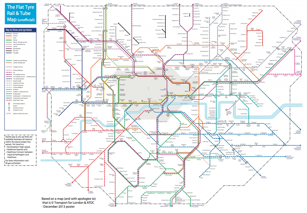
Ever been stuck with a bicycle with a flat tyre, in London but far from home? This has happened to me, many times, including twice in the last week, thanks to the usual combination of rain, grime and broken glass that seems to be endemic at this time of year here. & I don’t generally carry a spare inner tube, tyre levers and mini-pump.

Normally, I’m just aiming to get the bike home, where the toolset awaits, but how to do that? Full-size bikes are not allowed on buses, Tramlink, or “deep level” (i.e. bored) sections of tube lines – and until recently they weren’t allowed on the DLR either. TfL have this useful map showing where you can take them on their network, but this doesn’t include “heavy” rail lines which are generally more accommodating. Here is an equivalent map, but for First Capital Connect trains only.

So, I’ve modified the combined Rail & Tube Map to get the best of both worlds, and be sure of getting my bike home. Because I’m always looking for the cheapest way to complete such a recovery journey, I’ve included the Zone 1 area, as a place to try and avoid if possible. The orange-coloured London Overground lines then become very useful. I’ve also included, as red dots, a number of the “out-of-station interchanges” which aren’t normally shown on tube or rail maps, but which allow a by-street transfer between lines while counting as the same Oyster card journey. These make, for example, the GOBLIN (Gospel Oak to Barking LINe) a lot more useful, should you find yourself with a broken bike in north or east London, adding six valid connections which are otherwise unmarked on the main maps.

Most striking is the “hole” in central London, only one line passing through the Circle Line’s main loop. The Victoria and Waterloo & City lines are completely gone. A few less useful tube line sections are scattered to the north – I can’t imagine many people have ever taken a bike on a train from Cockfosters to Oakwood, for example. Your Oyster card also won’t get you to Heathrow with a bike – but then you presumably don’t live there anyway. The Central Line terminates just short of Stratford, which is annoying if you are trying to get back from Epping – but an out-of-station interchange at Leytonstone means there is a viable connection after all.

I “fiddled” with the original map in Illustrator – first deleting the banned sections, then rearranging station blobs so that they were connecting with blank space. It should be noted also that, if you end up with a flat tyre and are planning the tube method of recovery, that full-size bikes are banned from pretty much the whole tube network, and most of the rail network, during the weekday rush-hours.

This is a strictly unofficial mashup/modification of the original map which was produced by, and is the copyright of, Transport for London and ATOC. Here is a larger version.

[Update 1: Have added the Dalston OSI as multiple people have asked for it!]

Categories
Technical

This Blog has Moved!

The blog is now at https://oobrien.com/. The old oliverobrien.co.uk domain will continue to work for a couple of weeks. My leisure blog has also moved and is now at /.

Why? I’m consolidating the number of domains I own, to make management easier.

Categories
Leisure

San Francisco

IMG_1296ec

So… I went on a holiday last month to San Francisco. I’d been planning on a return to the west coast of America since a trip to Vancouver for a conference in summer 2012, and San Francisco is one of those places I’d seen a lot about but never actually visited. The excuse to finally make a visit was the combination of (1) a series of orienteering sprint events – Sprint the Golden Gate (2) cheap-ish flights – £525 return, and (3) various friends from school and university who have made it over there on a semi-permanent basis.

As December approached, the orienteering series was looking a bit shaky – permit problems, which I can strongly relate to with the inevitable permissions headaches that arise year on year with the London City Race. But I went ahead and entered. US orienteering races are extremely expensive to enter compared with the UK/Europe, due to insurance and expensive park permits needing to be included, but conversely the GBP/USD exchange rate has shifted quite a bit recently, making the US a cheaper place to visit than historically.

I arranged to crash on the floor of a friend’s apartment in the Marina District, and to meet up with four others who I knew were probably nearby. I had the Lonely Planet guidebook but the plan wasn’t to look at it that much! As is reasonable for a city of such beauty, I took a lot of photos (400+) and the best 70 are linked in the text below, and can be viewed on one page on Flickr.

Tuesday – Arriving

The flight over was OK, although the route was intriguing – going very far north, further than I thought we would, so that we were quickly into the Arctic Circle and, as happens at this time of year, even though it was the middle of the day, it got pretty dark outside. To possible take advantage of the unusually strong jetstream, which has been plaguing the UK with storms for the last month, we actually “overshot” the west coast of North America and headed right over Vancouver, before heading south-east to San Francisco itself.

I had a few hours before my friend appeared from work, so I got the BART into downtown, picked up a T-Mobile $3/day SIM, accidentally walked straight past the famous Apple Store and a bikeshare docking station, and wandered down to the Ferry Building, from where there is a great view of the Bay Bridge which currently has an evening lightshow. I then did a long, gradual walk anti-clockwise along Embarcadero, first heading past the new location of the Exploratorium and some outdoor exhibits, and then to Pier 39, a slightly kitsch but popular food/gift arcade. Taking a side-route out, I completely unexpectedly came straight across the sealion colony, which was making an amazing racket. Apparently they’ve been there pretty much since the pier was built. Checking the map, Russia Hill sounded like an interesting name, so I headed south, eventually making it to the hill up some impressively steep roads and flights of steps. I then headed over to the famous squiggly bit of Lombard and then a long walk along Chestnut down to the Marina District.

Wednesday – Walking

This was the big walk day – I walked 18 miles in the end. From the Marina District I headed north to the marina itself, to visit the Wave Organ sculpture there – with great views of Alcatraz Island and the Golden Gate Bridge – we’ve all seen a thousand images of it but there is no substitute for the thrill of seeing the most famous bridge in the world for the first time in real life. I then walked around the park at the pseudo-Greco-Roman Palace of Fine Arts, and then back to the shoreline, through Crissy Field and to the Golden Gate Bridge itself – the way on to the bridge wasn’t immediately obvious so I overshot a bit at first, and ended up under the bridge at Fort Point. After various tourist pics from and of the bridge, I headed off the far end of the bridge into Marin County. The walking route north doesn’t go much further (no pavement) so I had to get a bus from here to Sausalito, where I had half an hour to wander around – little to see though – before getting the ferry back to San Francisco. The ferry takes a great route, passing nearby Alcatraz Island, and with a symmetrical view of the Bay Bridge, before ending appropriately at the Ferry Building.

IMG_1348e

After grabbing lunch at some boutique stalls in the Ferry Building (think Borough Market but even fancier) I walked down Market to the famous cable car turnaround at Powell. After the inevitable wait in the tourist queue, watching cars getting rotated, I got a cable car over to Hyde and Bay, before walking back up Hyde – very steep – and down the wiggly bit of Lombard again. Then along Lombard to Telegraph Hill and the Coit Tower (closed) for a 360-degree sunset view. Down the wrong set of steps to Levi Plaza, back up the right set, down again to Downtown, around the Transamerica Pyramid, the Bank of America plaza & tree, and Union Square with its Christmas tree and Macy’s. Then a loop up to and around Chinatown and Dragon Gate, and a long walk along Geary, through Tenderloin (a starkly downtrodden area), to Japantown with its concrete pagoda and a pocket park. More hills found on the way back to the Marina District!

Thursday – Silicon Valley

First, a slow bus through rush hour, right across San Francisco to the Caltrain terminal. I made my connection with a minute to spare and got the huge and impressive Caltrain “Baby Bullet” double-decker train service down to Palo Alto. I then spent an hour walking to and around Stanford’s otherworldly university campus – including longer than planned in the unexpectedly massive Stanford team shop – before walking back to Palo Alto to get a lift to the Facebook HQ for a quick tour and lunch with a friend from university. Then an hour’s walk through American suburbia all the way back to Palo Alto station.

The original plan was to visit a friend at the Googleplex, but this didn’t work out, so I got a couple of buses instead over to the Computer History Museum. Highlights for me were an original Cray 1 Supercomputer (the circular black casing with “seats” still looks very cool) and an Apple I in a wooden case, signed “Woz”. Finally another long walk through Mountain View surburbia – Silicon Valley railway stations being sparse – and the Caltrain back into San Francisco. Signage is poor around the Caltrain terminal – I somehow ended up in front of the SF Giants stadium why trying to find my bus stop back. The bus gradually filled up with homeless people – it was a very cold evening, almost freezing, which is unusual for San Francisco – despite the best attempts of the bus driver: “you can’t go round and round for ever!”. It was a short walk up into Cow Hollow for an evening meal.

Friday – West

Another long-ish walk, this time south from Cow Hollow, first steeply uphill to Broadway, then to Alta Vista Park, then Alamo Park, and then the Lower Haight. I had lunch here at a cool Shoreditch-style coffee shop, but somehow missed out the more famous Upper Haight, by following the “Wiggle” cycle route to and through Panhandle Park. I cheated a bit here – Golden Gate Park and Upper Richmond go on a long way, so got a bus down to Ocean View and walked along the beach beside the Pacific, as the only clouds of the week gathered offshore. To Land’s End and the first orienteering sprint of the week, a short, but hilly forest sprint with a great multi-level ladders-and-platforms section in an old water facility. Then, a long journey from the far western tip of San Francisco, right over to Berkeley, to meet up with a schoolfriend. I didn’t see any of the university, or indeed much of Berkeley itself, as it was pouring with rain.

Saturday – Sprints

Three more orienteering forest sprints today. First, a couple in the middle part of Golden Gate Park, near the polo pitch. We were seeded and then started in groups. A warm down jog around the polo pitch’s perimeter track was 1.3km for a single lap! Then lunch in Irving – the second Chinatown of San Francisco, and then a long and slow bus right over to John MacLaren Park at the other end of the city for a final afternoon sprint. I struggled in the hilly terrain. Evening was a more formal dinner in the Mission District.

Sunday – Final Day

An early start to get to one last orienteering race – at San Francisco State University. A long way from the Marina District but thankfully a direct bus there, on a spectacular route – almost going across the Golden Gate Bridge, but turning at the last minute onto the Presidio, through Golden Gate Park and down 19th Street. The was the only campus sprint of the series and, though the area was small and limited, a good course was got out of it.

Afterwards I headed up through Stonestown to Forest Hill and Twin Peaks. Perhaps the most iconic view in the whole city from here. Then I headed north through tiny Tank Hill Park, to the edge of Golden Gate Park to the California Academy of Sciences which was having a free day (normally $25). It was, predictably, very busy, and the queues were too long for the earthquake experience, the tropical biome and the planetarium, so I only made it to the aquarium and the “Tellytubbies” garden roof, plus a rather underwhelming pen with a couple of reindeer and, randomly, some live penguins in a hall of stuffed animals. The CAS is an odd place really, the name is a bit of a misnomer, and the equivalents in London – the Science Museum, the Natural History Museum and the Horniman Museum’s aquarium, better combine the academic, educational, cultural and fun aspects of a good museum, while the CAS is only really strong on the large part. But I think we are a bit spoilt by our great museums here in London.

Finally, the journey home. A bus back to the Marina District, then another bus, then I just had time for another Cable Car journey back, from Hyde and Bay, to Powell. Then it was the BART to the airport and the inevitable jetlag to hit two days later…

An beautiful, exciting city with something interesting over every summit – I had a real sense of regret on leaving, knowing that life is just better here than back at home! I missed out on quite a few things to see that were on my internal list – the Exploratorium, the De Young Museum, Berkley University, the Googleplex in Mountain View, San Jose, the Cable Car Museum, Fisherman’s Wharf, the fog, the viewpoint NW of the Golden Gate Bridge, cycling, Muir Woods and of course Alcatraz.

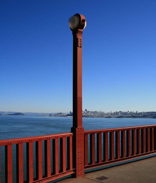
Golden Gate Lighting Post (1291)Greenland Mountains in Ice (5194)The Apple Store (5206)Bay Area Bike Share (5207)Bay Bridge Light Installation (5209)Christmas Tree at Pier 39 (5214)
Do Not Drive on Tracks (5219)Citizen Chain (5220)Wave Organ (1215)Alcatraz Island (1218)Wave Organ Detail (1223)Palace of Fine Arts from Baker (1233)
Palace of Fine Arts Interior (1246)Walk with a View (1252)Dogs and the Bridge (1258)The Golden Gate Bridge (1261)Bike Highway leading up to the Bridge (1265)No U Turn (1269)
Map of Bridge on Bridge (1271)San Francisco from the Golden Gate Bridge (1277)No Trespassing (1278)Golden Gate Bridge Cables (1284)Rivets in Red (1287)Golden Gate Lighting Post (1296)

San Francisco, December 2013, a set on Flickr.

Categories
Data Graphics London

Data Windows Update

datawindows

The charity auction for the artwork/map that I created with Dr James Cheshire, Data Windows, took place last night, at the Granary Building in King’s Cross. Our work was part of the silent auction section and received four bids, going eventually for £140. James and I are delighted that our map sold, and contributed to the fundraising effort.

Having looked at the other artworks that were on display, I was a little worried ours wouldn’t sell at all. There were many very impressive works, many that went for well above my budget, including a few for over £1000. The pieces by Dame Zaha Hahid and Lord Richard Rogers went for over £2000. The theme this year was drawing the area around Shoreditch, and the Hawksmoor-designed church of Christchurch Spitalfields appeared numerous times. My personal favourite work was Cycledelious, which was a bright multicolour stylised drawing of a Barclays Cycle Hire docking station. However it approached £200 before I had even got to it to put a bid down. The organisers’ strategy of very regularly topping up our wine glasses meant that I did very nearly end up bidding on several items…

You can find out more about how Data Windows was made in this earlier post.

Photo courtesy of Isla.

Categories
London Mashups OpenStreetMap

Ironways of London

london_ironways

It’s always irked me slightly that many online maps of London show the various tube services as straight lines between stations, or as idealised Bezier curves. Perhaps the regimented lines and angles of the official “Beck-style” tube diagram has meant that, when translating into a “real life” geographical map, people have tended to keep the simplifications. After all, if you are travelling around London on the tube or railways, only the location of the stations are important – not how you travel between them.

Focusing on the section of the DLR just south of Canary Wharf:

Google Public Transit view, using Bezier curves between stations:
iw_google

A typical “straight lines between stations” map – from CASA’s own MapTube:
iw_maptube

One of DLR’s own official diagrammatic maps:
iw_official

Where the line actually goes:
iw_actual

OpenStreetMap contributors have faithfully mapped most of London’s railways, including best-guess alignments for tube tunnels, using ventilation shafts on the service and “feeling” corners and curves that tube trains take – bearing in mind that GPS does generally not work underground. There are a couple of minor mistakes, such as orientations of the Northern Line curves near Mornington Crescent, and a part of the Piccadilly Line in north London.

I’ve taken this now excellent dataset, and as part of work to produce a comprehensive vector file of Transport for London (TfL) service routes, I’ve produced this interim map – the Ironways of London. TfL’s public service routes are highlighted in green. Lines in red are other train operator routes, sidings and depots, freight rail routes, disused lines, unusual chords and the odd ornamental railway. Many of these are obscured by the green lines of TfL routes, where the two coincide. There are a few missing sections, e.g. a couple of tunnels to the south of London are not shown.

The map here uses Google aerial imagery as a background, Ordnance Survey Open Data to show the boundary of Greater London, and OpenStreetMap to show the rail routes themselves. As such, it’s a nice mashup of the three major sources of free-at-point-of-use spatial datasets for London.

Here is the full size version.

There are a few other examples around on the net of the same thing – here’s an ESRI one. The Carto Metro one is excellent and is a level of detail beyond what I am aiming for.

In the new year I hope to complete and release the tidied vector data. [Update: Data released, more info.]

Categories
London

A Proposed Redesign for the Bow Roundabout

The Bow Roundabout is a busy and unpleasant junction in east London, with large volumes of traffic, including many bicycles and lorries. It forms a key part of the trunk network in London, distributing road-haulage around the city. River channels of the Lea Valley, industrial complexes, and the developing Olympic Park, block suitable alternative cycle routes.

boxarea

Bicycles generally only want to travel between central London to the SW and Stratford to the NE. Lorries and other motorised traffic generally want to travel in all directions, but because of both a flyunder (NW to/from SE) and a flyover (SW to/from NE) they only need to use the roundabout if wanting to turn right or left. The exception is local bus services between central London and Stratford, which have a bus stop on the approach slip roads.

This fundamental difference in the routes between lorries and other motorists (who are always turning left or right) and cyclists (who are always going straight ahead) has likely been a factor that led to three cycling fatalities in the last year, at least two due to “left hooks” (lorries on a cyclist’s right turning left across them). The junction approaches have been remodelled several times, most recently introducing a traffic-light-controlled advanced stop box for cyclists, to ensure they get to the front of the queue to enter the roundabout. However, the design is non-standard and confusing for cyclists – tellingly there is an official video showing how to use it. The design results in a forest of traffic lights, and the “safe” advance stop box and subsequent cycle lane refuges are too often blocked with motor traffic, stopped by numerous further traffic lights, during busy periods. This video from The Guardian shows this to dramatic effect – skip to 3 minutes in.

The layout is also unpleasant for pedestrians, who have to cross two slip roads, but the first of the pair is uncontrolled – there is no traffic light for them. The junction is still not fit for purpose, but, crucially, redesigns cannot reduce the overall flow of traffic through the junction, as it is at capacity. Diamondgeezer has detailed the problem from a pedestrian’s viewpoint.

Here is the current layout:

bowcurrent

Traffic lights are shown as black blobs. The pedestrian crossing points are showing with blue/white squares, and the pedestrian only section is shown as a dashed blue/orange line. To the east of the junction is a water channel, with a “floating towpath” beside it, shown with black dashes as a tunneled section. This route is not considered further here.

Here is my proposal:

bowfixed

Again, black dots are traffic lights, blue squares are crossing points, with an additional two blue squares showing bus stops, moved from the SW and NE slip roads. The road links to these bus stops are accessed only by buses and are shown in yellow. The cycle/pedestrian paths are shown as orange/blue dashed lines.

At first glance it somewhat looks like a roundabout in reverse, but this is not the case – there are four traffic-light-controlled “diamond” crossings, and traffic may only proceed straight across these.

This design improves on pedestrian and cyclist safety by properly segregating them from the road routes. For each direction, pedestrians/cyclists must make two crossings, both at right angles to traffic. At each crossing, there are two single-lane roads to cross, controlled by traffic lights which stop traffic on both roads at the same time, plus at the first crossing there is a bus road link which would be crossed via a raised zebra crossing, due to its low traffic levels.

Traffic negotiating the roundabout and turning left will meet just one traffic light, which would be green for just under 50% of the time. Traffic turning right will meet two traffic lights. Both will be red or both green, at the same time. This means that, again, nearly 50% of the time, traffic turning right would have green lights all the way through. There is no need for a dedicated pedestrian phase, with this design.

The only traffic which would not benefit from this design is the small amount of non-bus traffic travelling to/from the side-roads off the slip-roads to the NE, to/from the SW, and traffic travelling from the MacDonalds in the SW. This traffic would no longer be able to proceed straight across the roundabout to the NE unless it was allowed to use the small bus link-roads.

Disclaimer: I am (obviously) not a professional planner or traffic modeller, I am approaching this problem purely one of many regular cyclists on busy roads in London. Credits: The design was created in the Potlatch 2 editor on OpenStreetMap.org, and includes existing data from OpenStreetMap contributors and background aerial imagery from Bing. If trying this yourself be sure not to save your changes to the OpenStreetMap database. You can see the roundabout on an interactive map.

Categories
Bike Share

Citibike beating Barclays Cycle Hire

NYC Citibike’s meteoric rise continues – for October, the New York City bikeshare beat London’s Barclays Cycle Hire on average journeys per day, for both weekdays and weekends. Even more impressive considering that it’s only just over half the size.

Thanks to this release published today at the London Data Store, and this daily updating data from New York, I’ve been able to plot month-by-month figures, for the last three years for the Barclays Cycle Hire, and the last few months for Citibike, on the same graph. I’ve split out weekdays and weekends. Grey/black is New York City’s Citibike, while the colours (red, orange, green, blue) are the Barclays Cycle Hire for 2010, 2011, 2012 and 2013 respectively.

bch_numbers_monthbymonth

Click for the large version.

What’s even more impressive is that Citibike is currently physically smaller than London’s Barclays Cycle Hire. It currently has 330 docking stations and 4500 bikes, while London has 558 docking stations and 7600 bikes. These numbers don’t match exactly with official numbers, as I combine a small number of adjacent docking stations, and don’t count bikes in repair or otherwise unavailable for use.

London’s more temperature climate (a “warm/cool” city) means it should have a lead on NYC (a “hot/cold” city) in the summer and winter, while NYC may well be strongest in the spring and autumn.

Apologies for the rather lame looking graph. Excel crashed as I was setting it up, I sneaked a screenshot as the crash reporter popped up, but had to add the NYC data in manually in GraphicConverter…

Categories
Leisure

Walthamstow Reservoirs

walt1

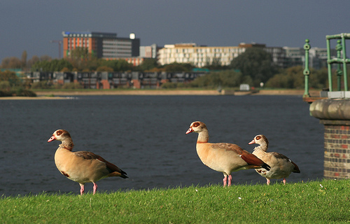
The Walthamstow Reservoirs are a true London secret, a huge area of lakes, trees and paths, which is publically accessible but largely unknown. The only people you are likely to meet in it are anglers and birdwatchers, both groups that thrive in a quiet environment and so I’m sure would rather the secret remained! But the area covers a huge part of central(ish) London and deserves to be known by more. There are plans mooted to open it up although nothing concrete. I took a trip into the reserve on Sunday, to have a look around.

Anyone can get in to the reserve, which is generally open during daylight hours (e.g. 8am to 5pm from October to March). There is only one public entrance, which is opposite the Ferry Boat Inn, on Ferry Lane, the road which runs across the Lea Valley, between Tottenham and Walthamstow. Tottenham Hale station is about a five minute walk away. The complex is owned by Thames Water, who enforce a permit system. On entering, go to the shack immediately on the right, fill out a pink form and hand it over to the warden there, along with £1. You’ll get half of the slip back, which acts as your permit.

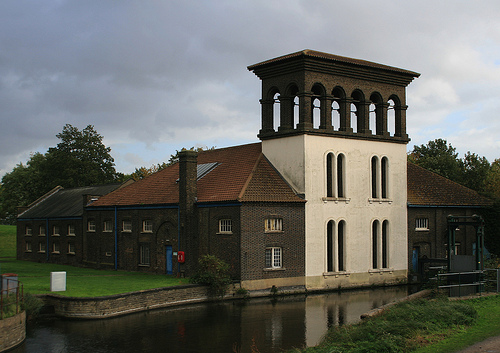
You then pass through a narrow passage underneath the London Overground “GOBLIN” route, past a decaying Victorian pumping station – with some attractive lampholders attached to it – and then to various paths radiating out from this point into the reserve.

walt3

At the far end there is The Coppermill, a historic building which used to, as the name implies, mill copper into coins. These days it is used as part of the reservoir operations.

walt2

View all my photos from the Walthamstow Reservoirs here.

Categories
London

Pan-London London Traffic Flows Map

traffic2

[Updated] As an update to the London Cycling Census map that I mentioned in the last post, here is a map based on similar data collected by the Department of Transport during 2012. The map covers the whole of London, over 3000 datapoints – in fact the underlying data is available for the major road network across Great Britain.

My earlier work was based on the Transport for London cycle census which was carried out in April this year, covering around 170 locations in central London only, mainly the major road network plus some cycle-specific routes. The DfT dataset is older, and is major roads only, but by covering the whole of London, it puts cycling (and the other modes of transport covered) in context.

By default, the map shows cyclists vs buses vs lorries. You can change any of the three colours to show cars, but these are generally very large values so the arrows for cars tend to dominate the map. Zooming in may improve clarity when this happens.

Looking across London, for initial set of just bikes, buses and lorries, it is striking to see how closely the lorries follow just the trunk road network. Bicycles also dominate the centre of the city, their levels dropping dramatically between inner and outer London.

The work is an output produced while working on the EUNOIA project. It is one of the datasets that the project will use, when calibrating a MATSim-based travel demand model of London, to check that the numbers in the model roughly match those seen in this dataset.

View the visualisation here.
The data comes from here.

[Update: I produced a major update to the map in January 2017 – it now includes data from 2000-2015, includes data on some minor roads, removes the arrows (as they don’t reveal much, for full-day counts), and allows a comparison between years instead of between modes. The data table has also been replaced with an interactive graph.]

Categories
Notes

The Tottenham Hale Gyratory

The Tottenham Hale Gyratory is a road structure I know well – I pass through it regularly. It’s actually made up of two gyratories: a large one around Seven Sisters, and a small one around Tottenham Hale itself, connected like a “flywheel”:

th2012
The “feeder” roads, all two-way, are shown in black. The one-way roads of the gyratory are shown in red, with an additional bonus couple of circles in green for the unfortunate buses visiting the bus station beside Tottenham Hale station. Having made it out of the main gyratories, they still have to “loop the loop”.

There are lots of problems with the design. Being a one-way gyratory, it pushes lots of traffic, from different origins and destinations, together. Traffic tends to hurtle along the single-way roads at speed. As such, it has always been an intimidating obstacle for both pedestrians and cyclists.

For example, people getting from the houses in the middle of the larger gyratory, to the northmost shopping area, or the station, have to cross a very strange road, where the traffic appears to be going on the wrong side of the road. What’s actually happening is this is where the two gyratories meet – or rather are only a couple of metres apart. As such, it is a confusing and unpleasant place if you aren’t in a car.

Recently, TfL has been working on replacing the gyratories with a more conventional layout. Last weekend, they made their main switch – completely removing the smaller gyratory, and making much of the larger one two-way. The remaining one-way section will also go two-way soon. The swirly bus station has also disappeared, and will reappear as only one circle, early next year. This is what it looks like now (including the soon-to-emerge bus station):

th2014

As you can imagine, the change has not gone down entirely smoothly:

thtweets

Plenty of cars have ended up heading along Hale Road, to find no connection with Ferry Lane, resulting in U-turns galore and extreme congestion. Others, coming southwards from Watermead Way or High Road, are still aiming for Broad Lane – the resulting left/right manoeuvre making the congestion still worse.

I’ll not mention the seperate cycle network that mirrored the smaller gyratory and half the larger one, which has been completely dug up in the last week…

Posted partly to commemorate the passing of the twin gyratories of Tottenham Hale but mainly as an excuse to draw the diagram.