Here’s some iPhone photos from my office window at UCL, over the last 12 months.
Categories
Here’s some iPhone photos from my office window at UCL, over the last 12 months.
The current cold snap is causing havoc with the UK orienteering fixtures list, with icy roads making getting to many areas impossible. The list makes for some grim reading:
SLOW’s own street orienteering event on Tuesday is also subject to an inspection on Sunday. Unfortunately, the forecast does not suggest things are going to be getting warmer any time soon.
Time for some armchair orienteering or maybe a Google Streetview Street-O race?
Once again I was up in the Scottish Highlands with JOK. We were staying in Onich, on the Glen Coe to Fort William road, but most of our mountaineering was in Glen Coe itself, apart from one day in Ardgour. It was generally cold but clear, with a decent amount of snow on the hills, and a biting northerly wind at times, so days were generally quite short but very scenic.
Here’s the GPS “shapes” of my walks over the six days – these are created by OSM automatically when uploading the GPX files.
Attackpoint log. Photos to follow…
2010 promises to be a very exciting year for GIS, neo-geography and information visualisation.
Potentially one of the most interesting events that may happen next year is a big shift on access to mapping data in the UK. Yesterday, the Communities and Local Government Department (CLG) published the consultation paper for opening up Ordnance Survey data. The consultation is open until March.
Also in March is the first Wherecamp EU, right here in London. I’ve looked on enviously as the neo-geos and proto-geos do cool things with spatial data over in the States at Wherecamp, and its associated “regular” conference Where 2.0. Now we get to do the same!
Geomob’s next evening, at my alma mater City University in January, has an interesting lineup of speakers, possibly including the author of Information is Beautiful – the UK edition of which is out shortly after in February.
This year was pretty amazing for opening up access to data – there’s a lot of it out there, now we just need to visualise it. Here are some lovely examples.
Finally, the British Library is putting on a major exhibition of historic maps from April – Magnificant Maps, which will include the largest book in the world – six feet high apparently. I saw their “London: A Life in Maps” exhibition back in 2007 and was highly impressed. They have an impressive collection and I look forward to seeing next year’s exhibition.
Season’s greetings!

Bauble from the OpenStreetMap Wiki

Here’s a video of the Brighton Street Race that I ran in last Tuesday evening. It was one of SO’s regular Tuesday night training events, with a difference – a one-hour, mass-start score event but with a compulsory 2.8km sprint section in “The Lanes”, with SI punching, which was to be completed in order. This section included a run around the outside of the Royal Pavilion.
The compulsory section could be done at any time in the hour, with the rest of the time getting as many of the score controls (which were the usual writing down answers to clues) as possible. I got almost all of these, including one in the bandstand on the shorefront.
I’m easy to spot as I’m the only one wearing shorts (it was about 2°C). However, the fast pace of the sprint section, and the ever-steepening climb up to the station early on the race, warmed me up just fine.
Excited to hear that there might be a full-scale city race in Brighton in the future. The big slope the city is built on has the potential to make it quite an interesting one!

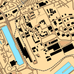
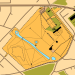
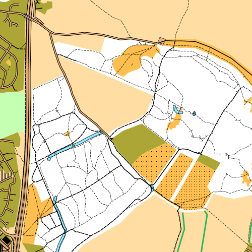
A public preview of the on-the-fly mapping that is being used for the CensusGIV project is available at OpenOrienteeringMap (OOM).
The same mechanism that will be used to produce the varied choropleth maps of census data is being used to produce the “Street-O” and “Pseud-O” maps on OOM. The main differences are that the map image files, or tiles, are more aggressively cached – as there’s only two maps rather than millions – and the designs are in an XML file rather than being specified on the URL, as they are much more complex than simple thematic choropleth maps.

Further details of the construction are in a posting and information page on my personal blog.
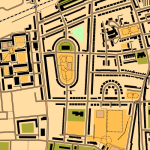
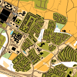
Top: “Pseud-O” map of Furzton district in Milton Keynes. Bottom: Edinburgh Old Town “Street-O” map.
With the OpenStreetMap spatial dataset of the world, and the excellent map rendering toolkit Mapnik, it’s quite straightforward to make theme-based maps, such as OpenCycleMap, OpenPisteMap, OpenHikingMap and OpenWhitewaterMap.
All very well, but what about orienteering maps? So, here is OpenOrienteeringMap. For the moment, it just covers the UK, but there’s no particular reason why this couldn’t be extended to cover the world (except that the postcode-finder only works in the UK). [Update – it now covers almost the whole world!]
The map is created on-the-fly, using a process developed by the OSM community that I’ve built on for my day job at UCL. The map is created on a quite fast computer, but because it is created on-demand for areas people haven’t visited before, it may run slow if a few people are looking at it at once – and you’ll need a fast internet connection as the map is delivered as PNGs.
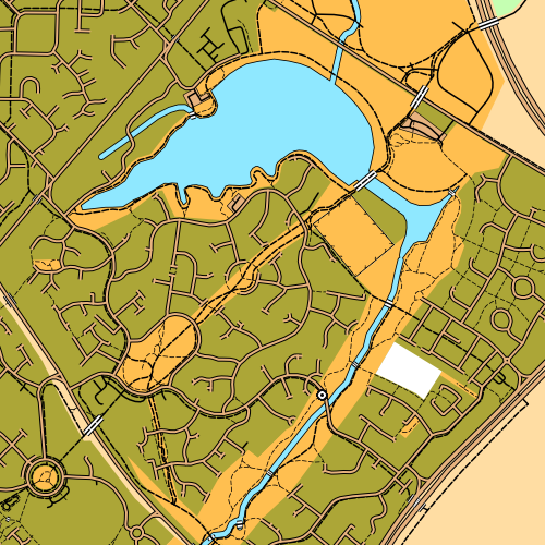
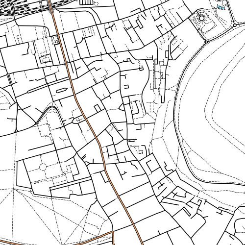
There are two styles – Street-O and Pseud-O.
This attempts to recreate the “minimalistic” feel of street-O maps, as used for informal street events in London by the central clubs SLOW and LOK, and in other areas around the UK. Only roads, tracks, paths, rivers/lakes and railways are shown, the maps are high-contrast (black on white) and have little colour. The few colours that are on the map – for major roads and water features – are the “official” ISOM standard colours for these features.
OpenStreetMap data has been used for one street-O before – my Bow race in September, although here the data was pulled into Quantum GIS and a vector-based PDF was produced, allowing maps to be printed at high resolution.
This is a less standard but richer map. It uses many more features in the OSM data, where they correspond to regular orienteering features. OSM data, for ~99.999% of areas, is not detailed enough to correspond to that on an ISOM map, but it might be sufficient for basic urban orienteering events in a few places, or the odd trail challenge. As the OpenStreetMap dataset continues to be added to and enhanced by its contributors, so the orienteering map will increase in complexity and accuracy. Again, the colours are as officially defined in ISOM. For now, it’s fun to look at the whole of the UK with the ISOM look-and-feel, but let’s not run any serious events with the map! (More on ISOM orienteering maps and OSM.)
The postcode finder uses the c. 70000 postcodes supplied by NPEMap (with contributions from FreeThePostCode and the postbox locator project) so should get you to within a mile or two of where you want to be, in urban areas.
Explore the map and let me know about any big problems with the cartography or functionality via the comments here. I’m not interested in missing data complaints for an area though – OSM is a project produced by the efforts of volunteers, so if your area is blank, it’s because there isn’t an interested local. So go and map the area yourself, and add it to OpenStreetMap so the whole world benefits (and let me know so I pull in the updated dataset!)
More information about how the map is made is here.
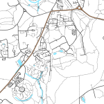
Top: Good to see the efforts of the Milton Keynes mapping party I organised in May make it to an orienteering map. Upper Middle: Edinburgh’s Old Town. Lower Middle: Shotover Wood, near Oxford. Bottom: Great detail in Putney, thanks to an enthusiastic local contributor in the area.
I’ve just set up the ability to embed videos in the blogs running off my department’s blog server, so here’s a couple of videos to test it works.
Vimeo example video:
Interland 2009 from Ultimate Orienteering on Vimeo.
Youtube example video:
My boss (Dr Pablo Mateos) and I gave this presentation today as part of this term’s CASA Seminar series here at UCL. My bit starts at slide 22 (of 60! – we just about managed it in the hour but only by rushing at the end.)

CensusGIV – Geographic Information Visualisation of Census Data
Note that the censusprofiler site mentioned a couple of times in the presentation only has a (very out of date) blog on it at the moment, and the prototype itself is not yet available for general use – with luck, an alpha version will be available to play with by the end of the year.