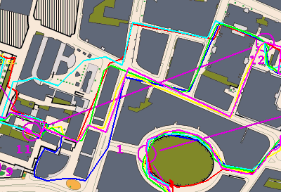
City Race competitors may have noticed the unusual way that the controls were mounted. Controls going walkabouts is always a worry for urban events, and although the City is largely deserted during the weekend (apart from teams of construction workers and window cleaners, it seems) it was still a concern. The biggest worry was uninformed security guards and police officers, rather than vandals, destroying the controls. The City is a high profile and high security area, and beeping boxes of electronics, with flashing lights, attached to skyscrapers, would probably raise a few red flags.
At Oxford and Stockport, marshals were at every control site – the safest way, and a good way to explain what is happening to the public, but also a real challenge in getting the man-power out – non-orienteering helpers need persuading to sit out on a street for two hours in (possibly) the rain, while orienteering helpers are probably needed to run the assembly area. Non-orienteering volunteers were used at Oxford, and were given a free T-shirt as an inducement. At Stockport, the numbers of controls used were minimised. In both cases, the volunteers were highly visible, and I found myself generally spotting the volunteer and then seeing if I could see the control – perhaps not ideal if the volunteer is not on the feature itself.
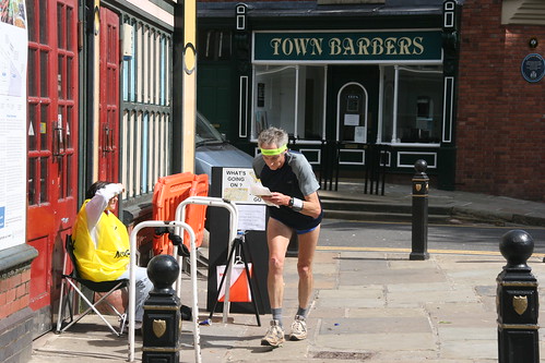
A marshaled control in Stockport. Photo by orienteeringmccann.
In Edinburgh, metal cable was used to secure the controls to immovable objects. This was very secure, but made punching slightly difficult, as the cable went through the punch hole. Newer SI cards have a fatter tip and so would find punching even more difficult. In fact, you just need to hold the tip at the top of the hole for it to register, but competitors might still be put off by the inability to do a firm “punch”.
At the City’s test race, at Queen Mary University in July, I used thin (1.5mm) metal cable, and bolts, for the controls in Mile End Park, which were considered more likely to be vandalised. A number of useful points came out of this – firstly, the time taken to secure the wire was considerable – requiring a wrench to tighten the bolts. Also, pre-cutting the wire without measuring the tree/post diameter is not good. One of the controls was around a bush, that was too wide for the wire to fit. So, I ended up looping around a protruding branch. Some youth spotted this and simply looped the control off the bush and into the nearby lake. Thankfully this was retrieved by an orienteer, so didn’t affect the race too much.
My initial thought was to use thicker metal wire for most of the controls in the City Race, and have marshals for all the controls in areas likely to be popular with passers-by. Planning and controlling reduced the number of such controls from around 10, to 5 and then just one, which was good. However, on testing out the wire at Glover’s Wood, the previous weekend, we found that it was very difficult to get a satisfying punch, particularly with the fatter SI cards. The wire tended to bend down through the hole, as it was looped, rather than being flat against the side, reducing the space even further. Another solution was needed.
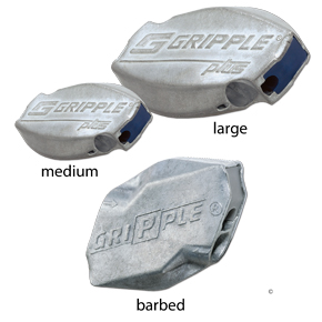 At the same time, Vince (the assistant organiser) suggested that instead of using time-consuming bolts, we use Gripples – these are metal blocks where, on putting the wire in, it won’t come back out – a bit like a giant cable tie. The grip is excellent, making it very secure. The advantage is that putting the control up is much quicker. The disadvantage is that the wire has to be cut to release the control at the end – there is no way to take apart the Gripple.
In the end, we used a mixture of 2mm and 3mm wire – we had a limited number of Gripples of different sizes to fit each gauge. During the planning phase, an estimated wire length needed, was made.
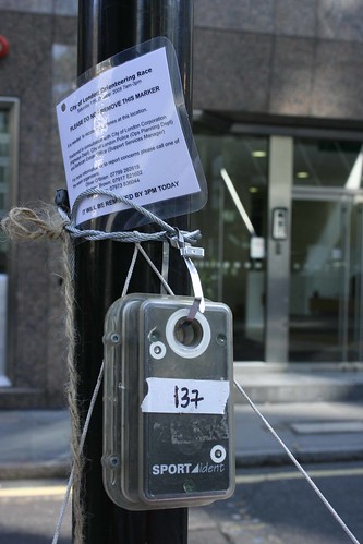
The breakthrough was discovering steel cable ties – these work much like the plastic ones, but are much stronger (and more expensive). I found a local supplier and bought 100 Hellermann Tyton MBT11S 30cm ties made of “Class 316” stainless steel, for £28. The metal is very flexible, so easy to loop, but also very strong – I’ve been trying to break a test one apart, using pliers and also metal-fatiguing it, and failed. They can also be cut with the same wire cutters that cut the wire, and are flat, so don’t obstruct the control hole. On a couple of controls where we ran out of Gripples, we linked together several of these in place of the steel wire. For all the others, the cable tie was looped through the control, and through the steel wire, to which was also threaded the control flag (hung down from the string), a plastic back-up pin punch, and a laminated, punched A6 notice explaining to passers-by what was going on, with phone numbers for the organisers.
The notice was particularly important as, at the Rat Race a couple of weeks before, a control was found by a policeman and removed – its whereabouts only discovered after the police phoned the SI unit manufacturer (whose phone number was on the control’s base).
The Gherkin control – this one did fall apart as the Gripple was faulty, so the wire has been wrapped around itself. Photo by Chris5aw.
We also stationed marshals at three of the earliest controls. These happened to be the ones I thought were most likely to be moved on by security guards, but, also being the first ones, the marshals could help out new orienteers with the way to the next control. Because the controls were still secured, the marshals only went out at 10am, and could go back once most starters had passed, rather than waiting until course closing time. Marshals were given bright red hoodies to wear, so that they looked official, and as an incentive.
On putting the controls out, we had two teams of two – one with pre-cut lengths and one using a roll of wire. The sites weren’t tagged – as, when visiting them the previous evening, they were either in parks with locked gates, or generally surrounded by loads of Friday night drinkers – in a couple of places, the street/alleyway concerned was completely blocked by them. So, the control teams had a manifest, with a photo of each site, the control description, an extra detail (e.g. secure to right hand side of the left bench) and the wire lengths. The two controls which we weren’t able to secure – one because of its location and one because of a landowner request – went out later, at 10am, as courses opened, and were then continuously manned.
The mechanism was a success, with no controls moved. The cables, cable ties and notices had to be discarded, but the Gripples, controls, punches and flags could all be retrieved for future use.
A few points for future use – the control hangers may want to use gloves in future. Most of the hangers suffered point cuts from the frayed steel cable – the way the cable is threaded through the Gripple meant that bare hands tended to get jabbed by the wire. Also, having teams of two was definitely useful – one person could assemble the items around the wire, while the other person gets each item and threads the cable tie. It was easy to get the control box the wrong way around, and difficult to correct it once mounting. Punching the control from the wrong end doesn’t work, so some controls will have needed to be rotated around for successful punching (although no one complained about this). Finally, one wire cutter is needed for each person collecting controls back in. We only had three, so we could only have three collectors. The lack of stakes makes collecting large numbers of controls easy to do with a small bag, though.

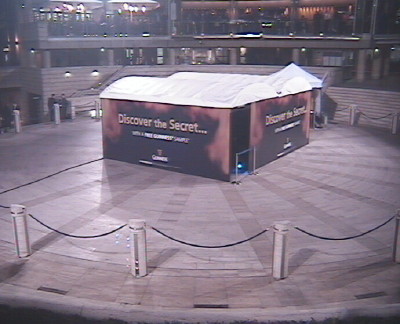
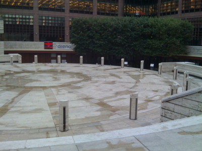
This control probably should have been a bit more accessible. Photo by maprunner.