Categories
Bike Share London

All the Docks 2

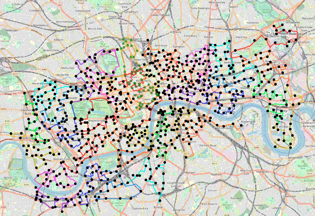
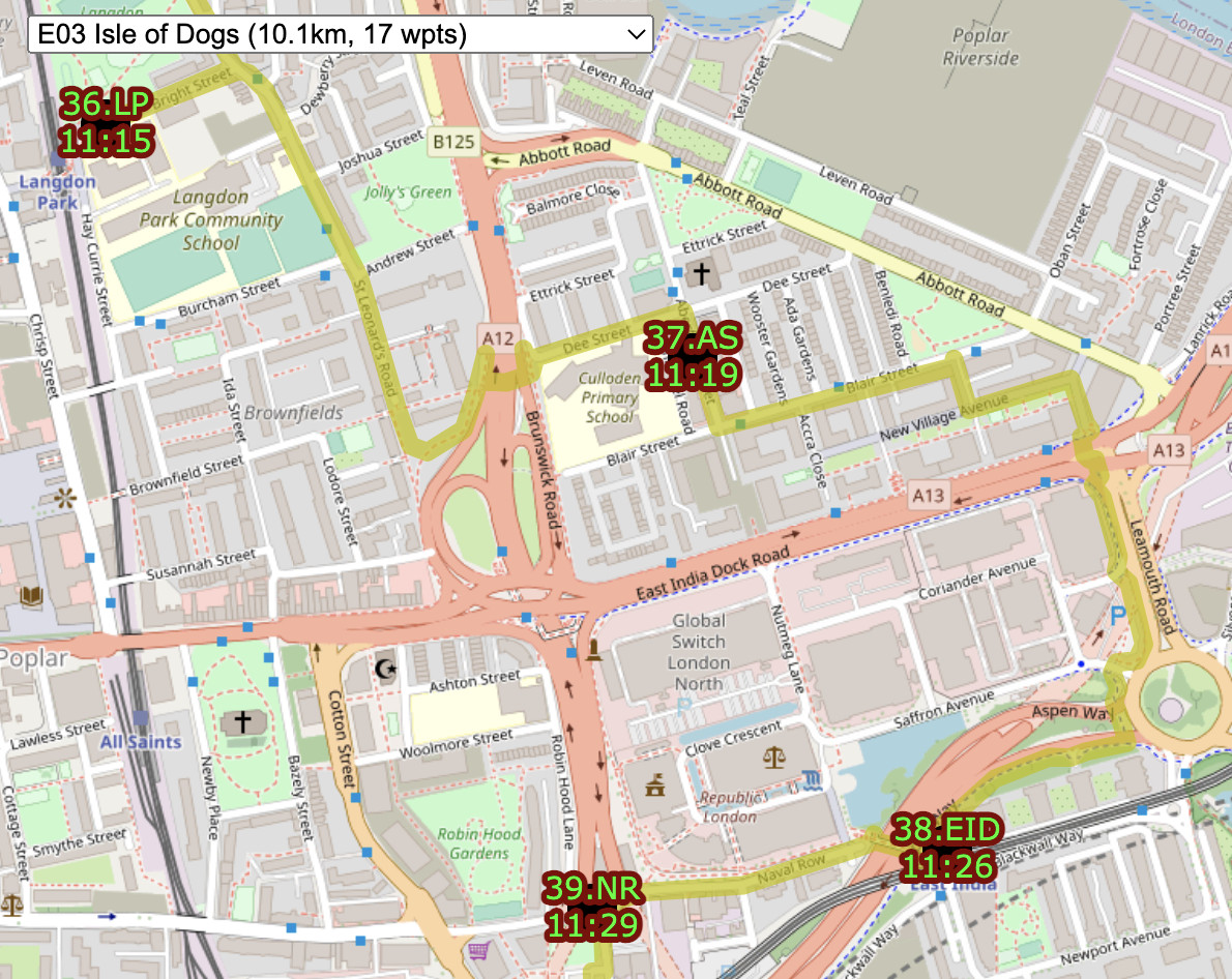
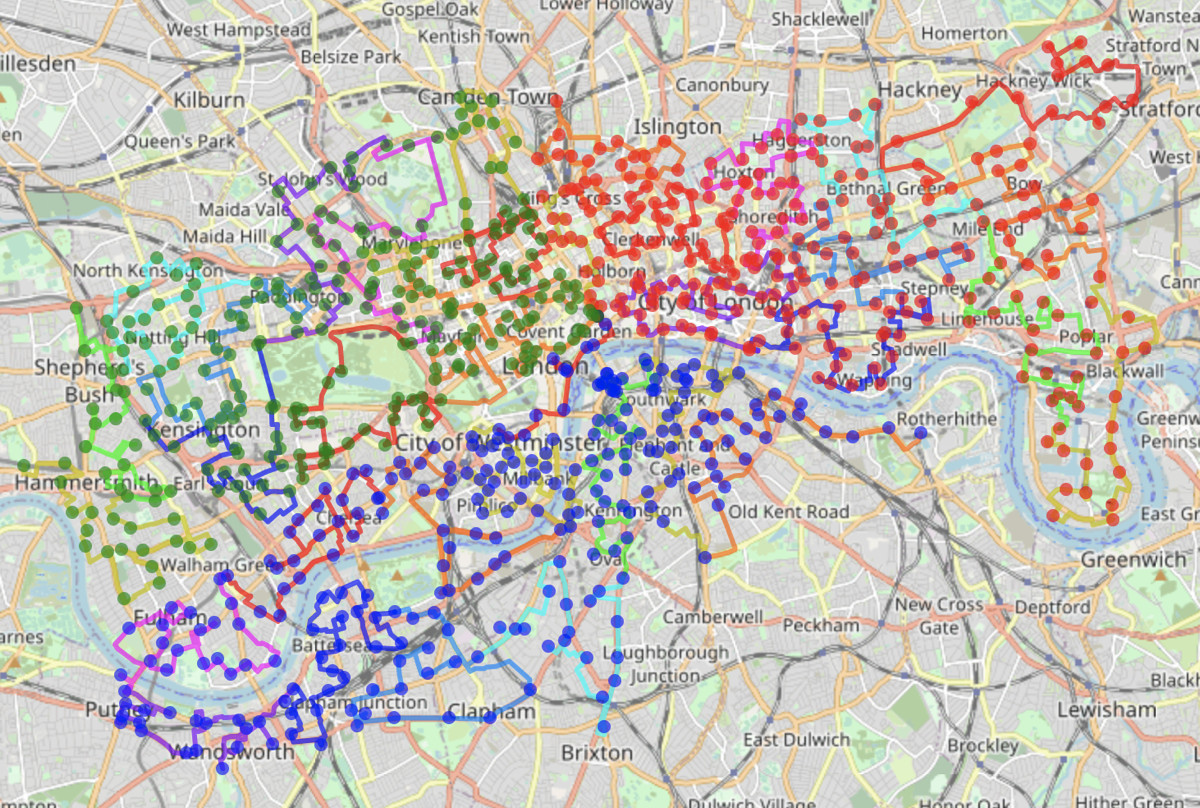
Yes, we did it again. All the Docks 2 took place in London on 9 July. Five teams (up from three last time) each cycled between a fifth of the Santander Cycles docking stations in London. I again did the routes, splitting up the ~800 docking stations into 5 routes of 160 docking stations apiece. To make it more of a challenge, this time we started in central London, at the same docking station we were all to finish at, with the teams looping out from central, before returning.

Each team was to visit exactly the same number of docking stations, with routes measured at around 71.7km +/- 1km maximum, to make it a genuine equal challenge.

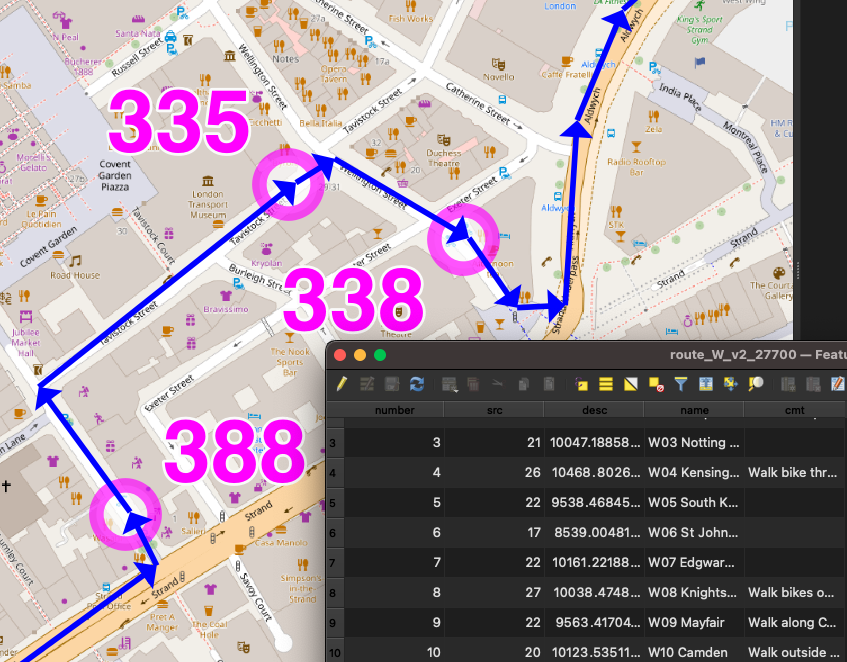
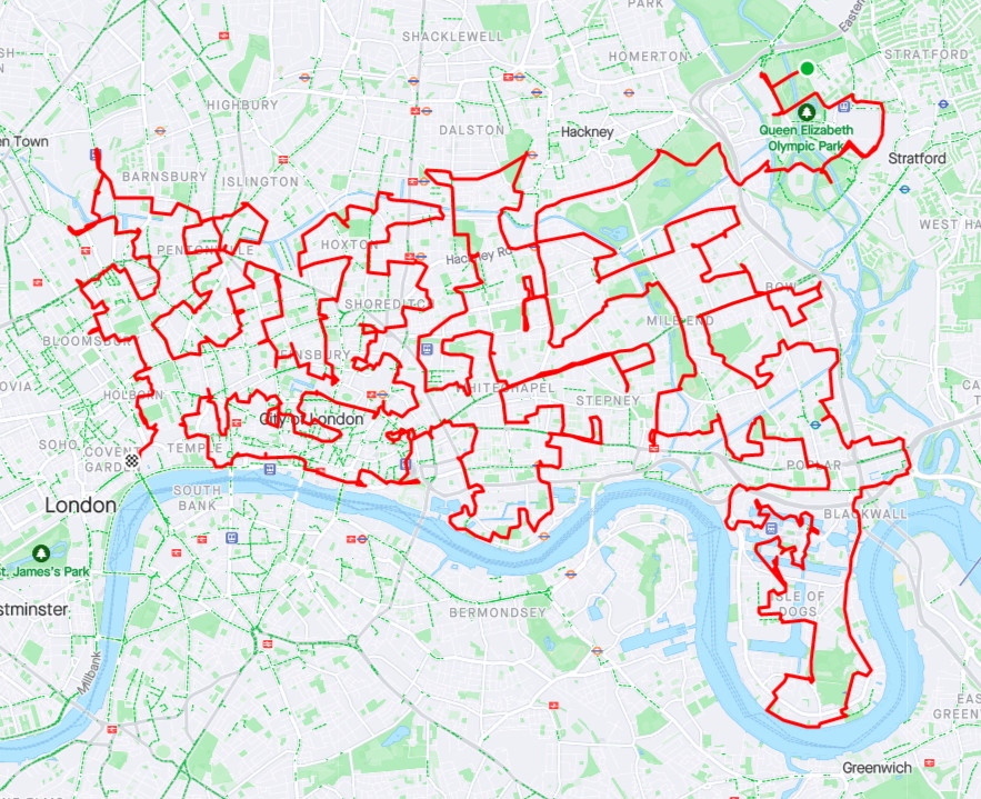
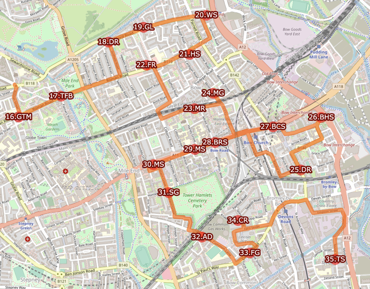
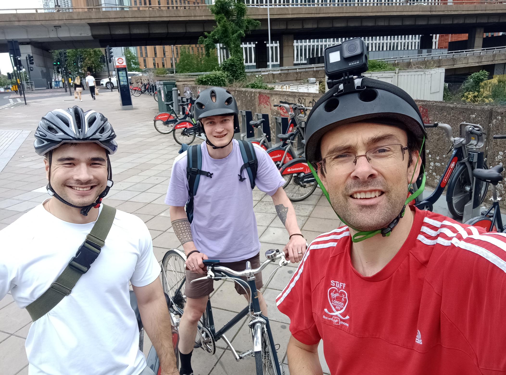
I was on Team West this time, with Westfield London and Hyde Park being the highlights, contrasting from the Olympic Park and Canary Wharf last time round. Team West was an all-UCL team.

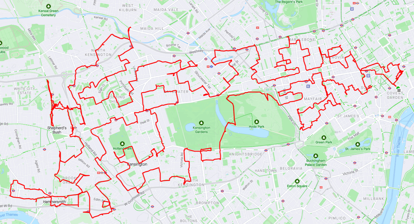
(Route courtesy of West Team lead rider Dr James Todd)

What went right?

Nearly everything this time.

All teams started and finished. Four of the five teams finished within 5 minutes of each other, which I think is great after nearly 8 hours of cycling. One team finished half an hour quicker than the others, and therefore won, but then they did skip stopping for lunch. Fair play to them.

The weather was good, and Sunday traffic was light so the challenge was more pleasant.

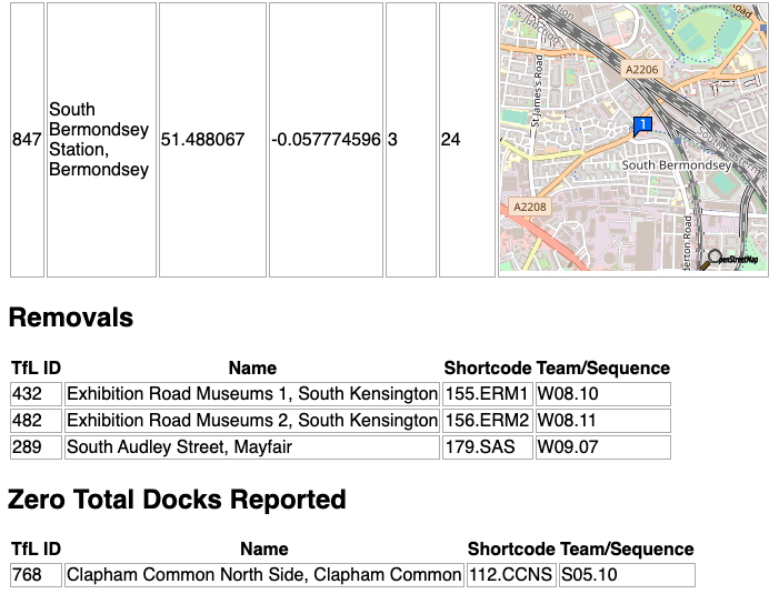
TfL didn’t open any extra docking stations during the day, so no on-the-fly replanning was needed.

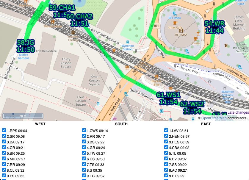
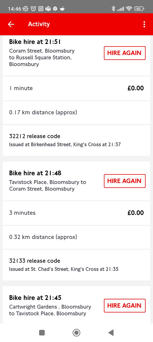
All teams used my online map to record their docks so we got a nearly complete dataset (albeit with a few errors in it) showing the teams docking.

The challenge had an official website this time, courtesy of overall coordinator Stephen Bee.

Prof Wood at City used the live API to generate some really nice live visuals of the progress, which he later turned into an animation:

The routes seemed to work OK – there were some quirks, such as the nearly 2 mile cycle North Team had across South Hackney to get to the Olympic Park. Originally, this area was Team East, but adding this in to the Team North route was essential to balance the lengths of the different routes. For Team West, we only had a couple of no-entry signs that I hadn’t anticipated and the odd road closure due to building work. Team South and Team Putney both had to cross the Thames four times.

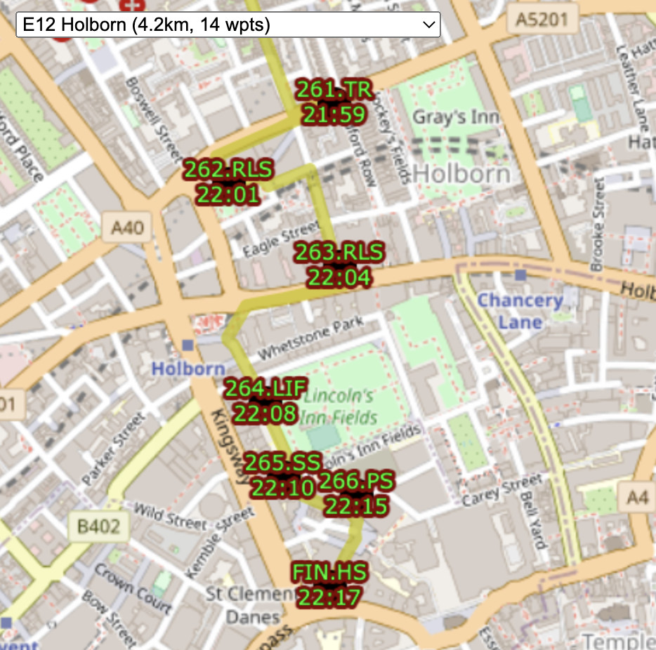
This time I put each stage (stages are approximately 10km or 1 hour of cycling, so each team had 7 stages) through a TSP solver – I wrote some Python code to make appropriate calls to an OSRM server (routing.openstreetmap.de) and modify the results to create a GeoJSON, viewed in QGIS. Unfortunately, the pre-defined vehicle profiles available on the server meant that the cycling routes avoided trunk roads, whereas in London they are generally fine to go on, and also the router was too enthusiastic about using pavements for quite long sections, and even steps (a no-no for the 25kg Santander Cycles bikes). Next time, I would run my own OSRM server, with a a custom defined profile more suitable for London cycling. But the routes generated did suggest some optimisations and I was able to reduce the route lengths by around 1%, in places substantially rerouting sections. So, a win overall for using TSP engines.

Everyone seemed to enjoy themselves and the ~4:30pm finish was ideal for a couple of pints outside at the pub opposite.

What went wrong?

The biggest problem was the London 10K. This was happening almost unbeknown to us, except that I luckily realised it was happening and going to be a problem, when I read a TfL summary of events happening, the night before. The impact was quite major on the start of the event – I suspected that TfL would, unannounced, turn off a number of docking stations, but worse, the route was blocking the first stage for two of the teams – Team Putney and Team West started right down the race route. Urgent replanning the night before was needed. Team Putney did a dramatic diversion out via Waterloo and Lambeth Bridge (taking on some Team South docking stations). In compensation, Team South picked up some of Team Putney’s docking stations at the end of the day. Team West’s route would also be blocked at Regent Street. In the end, a diversion around Oxford Street, and a bit of replanning to add in a loop, didn’t lengthen the route too much. In the end, 5 docking stations were indeed turned off, they came back online in the mid-afternoon, just before the teams closed in on them, so all’s well that ends well. Probably, Team Putney could have sneaked down the race route, as the race started at 0930 and we started at 9am – and the course wasn’t completely sealed off until the runners started.

My team (Team West) suffered a couple of technical problems due to docks going offline. This meant that the bikes docked, but journeys did not “end” in the Santander Cycles system. Therefore, a new journey could not be started. These issues were solved with phone call to the helpdesk, however, the first time, the operator made us jog back to the previous docking station (as we had already cycled on with another bike/account) to confirm cycle numbers to prove we were there. Very annoying and we lost 15 minutes this way. TfL should know when their docking stations are offline. When it happened near the end, we again had to jog back, and used the remaining key for the last two hops. In the end, it didn’t deny us the win – we’d already lost that by having too leisurely a lunch. (Two accounts are necessary for the challenge, to avoid a 30 second account timeout between successive hires).

There were again some problems with the team version of my live map. The API response went quite slow during the day, even though I had tested it to work within a few milliseconds. This meant it was easy to tick, and then accidentally untick while waiting for the response to come back. Future UX tweaks would mean a confirmation needed to untick, or to tick a station later than the next one in the list.

Routes generally worked well but Team West was surprised by the sudden removal of the cycle track on the inner side of the Hammersmith Gyratory, necessitating a diversion and then some hairy lane swerves to get back on track. Sudden ending of otherwise good cycle infrastructure is a long-standing London quirk. Looking at maps, even now, I still can’t work out how cyclists are supposed to get from Talgarth Road (north side) to King Street. Maybe via Shortlands? But then why have such a great cycle path on Talgarth Road itself?

I need to automate the process of creating the routes and the files generated from the routes, particularly going from the GeoJSONs in QGIS, to the GPX route/waypoint files and the dock list. Like last time, I went through four iterations of the routes, each correction and publishing cycle took 2-3 hours.

Late changes, mainly relating to the London 10K replanning but also the need to get five route with the same number of docking stations and essentially the same length, meant I couldn’t include some “iconic” London cycling pieces in the routes – namely the Kensington Gardens Broad Walk, Parliament Square, or Battersea Bridge.

Team leads were given Go-Pros to wear, which were set to do time-lapse imagery, but these soon ran out of batteries. A different kind of device might be needed for this kind of thing.

We were expecting more on-the-day involvement from TfL (both technical and promotional) and some other data organisations as the event was part of London Data Week, indeed this set the event date. In the end, apart from Prof Wood’s excellent contribution above, we were on our own. It is possible some further outputs may appear.

Some final notes

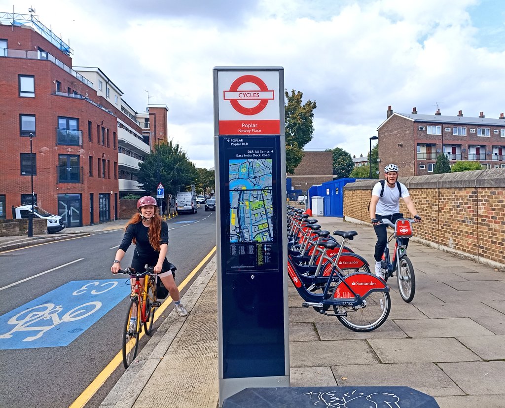
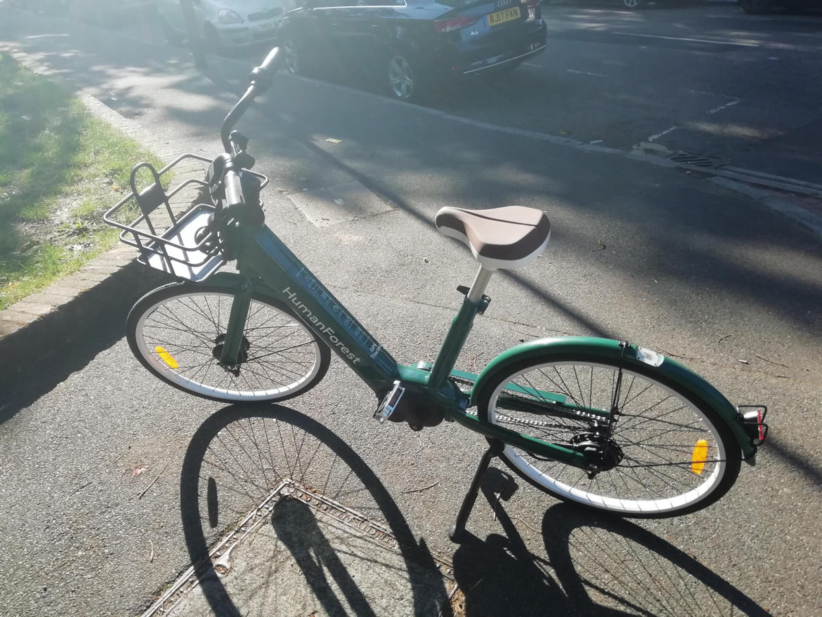
All teams used at least one Santander Cycle between each dock, docking and undocking each time, to make the challenge official. There were no rules on what bikes the other members could be on, so one person had the great idea of doing ~55 minute rentals on the Santander Cycle electric bikes, each time. This is great because it makes the challenge more enjoyable, having an electric boost. It also will have only cost an extra ~£8 or so (as the surcharge for electric is £1 for up to an hour). The only drawback is no easy way to mount your phone on a hire bike. But i think I would be happy to trade that for an easier pedal.

Until next time…

Categories
Bike Share London OpenLayers OpenStreetMap Technical

All the Docks: Technical Notes on the Routes and Map

Routes

I created GPX route files for the challenge. These were created manually in QGIS, using the OpenStreetMap standard “Mapnik” render as a background, by drawing lines, with Google Street View imagery used to check restrictions.

I split each team’s route into 12 stages (so 36 altogether), which were initially each just over 10km and ended at a docking station. Each stage contained between 10 and 40 sequential legs to docking stations. I’m not sure I would trust proper routing engines (based on Google Maps or OpenStreetMap, normally) to have found better routes on each leg between each docking station, than me and Google Street View, largely because many London boroughs have been experimenting a lot recently with Low Traffic Neighbourhoods (LTNs) and modal filters (e.g. two way for bikes/one way for cars). But I did run a TSP solver (RouteXL) on 3 of the stages and in 2 cases it did find a slightly shorter ordering of the legs, within the stage. So I would probably use a TSP solver more for a future iteration of the challenge.

The three route/team files were saved in British National Grid (EPSG27700) GeoJSONs (technically not allowed by the spec) so I could get proper metre distances ($length) auto-updated into a column, for each stage, during planning. The stages had a number column, and were numbered sequentially. Having a number column results in LineStrings in the GeoJSONs and GPX routes/routepoints rather than single MultiLineStrings and GPX tracks/trackpoints. They were then saved as WGS84 GPX files. I (mis-)used a very limited set of column names (name, number, src, desc, cmt), due to the restrictions with the GPX specification – I didn’t want to use GPX extensions.

It was important to have three separate GPX files so that each team would need to load in just a single file to their navigation device and not see docking stations/routes from other teams). But it did make preparations a bit harder for the online map.

The docking stations were imported in via a TSV file, then saved as GPX waypoints (column names again restricted to src, desc, name, and cmt), and the relevant ones were manually appended to the GPX team files. The GeoJSONs were retained as my master editing files, as QGIS cannot easily edit GPX files due to them containing multiple geometry types.

I would certainly like to try a more automated approach to the routing. It did take a substantial amount of time – probably two evenings for each of the three routes, and a further evening for each route to enumerate the docking stations, fine-tune the routes and reorder any sliced up GeoJSON LineString segments (part-stages) back into the correct sequence. The reordering was needed as QGIS would incorrectly reorder parts of the route that crossed over itself, when it was sliced up.

But an automated approach would require a method that deals with docking stations that are just 10m down a no-entry street (so you’d just walk it), which is hard. Currently they are represented as a point defined by TfL through their API (and separately in OpenStreetMap) which may be the location of the “totem pole” kiosk but not the docking points themselves. In routing or GIS systems, the docking station needs to be represented as an area (within which you would walk the bikes) plus a (multi-)line (representing the line of dock points – some of these are quite long – some have significant gaps, and sometimes they are split on either side of a road). Potentially, the point representing a docking station really needs to be an area, and that area can extend up to the nearby road junction to deal with the one-way issue.

Future Improvements

In terms of the general design, a few things could be changed for a future challenge (some of these I mentioned in my previous blog post):

  • Ensuring that participants are well away from the finish at around the 60-80% stage, so that they are less likely to bail at that difficult time of the day, because the remainder of the challenge is then a kind of “run in” to the finish, rather than routing them away at a late stage.
  • When participants pass by another docking station twice, they should visit it on the first occasion, not the second time. (An exception is when it is on the wrong side of a dual carriageway, particularly one with a median barrier). Otherwise there is a danger of it being missed on the return.
  • Build specific meal stops in.
  • Maximum of 200 docking stations/10 hours per team.

The Web Map

By comparison, building the web map was straightforward, probably just one evening’s work to build the map page itself as a basic OpenLayers map reading in GPX files and with simple browser-based geolocation, and one further evening to build a “team” version of the map that allowed ticking off the stations, the action being stored in a database, and a time string echoed back to the web map (and other viewers, on a Javascript timer) as confirmation. The database had two tables, a summary table with a row per docking station, and an action log which recorded the dock’s TfL ID, timestamp, event type and the submitter’s browser user agent string ($_SERVER[‘HTTP_USER_AGENT’]) in lieu of logins/IDs. It was fairly easy to assign a manually assign each user agent to team, post-event.

Each docking station ended up with 4 identifiers which feels a bit too many, but it kind of made sense:

  • an integer TfL ID (e.g. 761)
  • the TfL Name that appears on the totem pole (e.g. Gower Place, Bloomsbury)
  • a shortcode which was the sequence number and the initials of the first part of the TfL Name (e.g. 37.GP). There were some duplicates across the team. FIN.HS was a special shortcode for the finish for the two teams that didn’t have that as a docking station in their “zone”. One newly added docking station had “A” appended to the sequence number of the previous, rather than having to renumber everything.
  • a unique sequence code which was the team, stage and docking station order within that stage, (e.g. W02.15). This was used as a logical ordering of the file and to help with assigning each docking station to its stage on the online map.

I also listed an “actual sequence” post-event ordering, e.g. W038, in the final results file.

I could have used the sequence code on the map but felt the shortcode was the most useful concise way of identifying each station to the team as they approached it, and hopefully the simple number would result in any missing out being spotted quickly.

I built a special “diff” webpage that compares our docks file with the live data (via BikeShareMap) every 2 minutes and this alerted us of any new, closed or zero-capacity docking stations, plus a list of full ones. There was one that opened a few days before, but none on the day, thankfully!

Future Improvements

I do think that using fewer intermediate routing points on each leg would be better and would allow for turn-by-turn satnav directions. Having said that, having street names called out is of limited use as they are often hard to spot on the ground, so the breadcrumb trail approach we used worked well.

We had paper maps (just screenshots of the website) as a backup. I never used them, and I think Team South used the website. Team West used them exclusively, with a separate person using the website to tick off.

I would have liked to have had a single source of docking station locations. In the end, they were:

  1. on TfL’s API, which is fed through to a CSV on BikeShareMap every two minutes,
  2. on a CSV file on Github,
  3. as GPX waypoints appended to each team’s GPX routes file, and
  4. in my database for recording times on the ATDMap website.

1 and 2 were automatically compared (see above), 2 could be added to QGIS to compare and generate GPX for 3, and also imported into the database table (4) but this would all be manual steps.

Links

Website map with the timings: https://misc.oomap.co.uk/atdmap/

Route GPX files and timings CSV: https://github.com/oobrien/allthedocks

Strava link (Team East): https://www.strava.com/activities/7908548122

Categories
Bike Share London

All the Docks: How it Went

On Monday I spent a lot of time (over 13 hours) cycling between 268 docking stations in London. It was for the All the Docks challenge, as part of Team East, with Joe (Be.EV CCO, and ex-ofo) and Jeyda (fettle CEO). There was also an all-stars Team West and Team South (including Voi, TIER, Zwings, and CoMoUK people – see this blog post for the announcement), and, across the three teams, we aimed to visit all the docking stations in London in a day.

Black = done. Green = not done. From the web map.

Team East: By the numbers

  • Three challengers: two on Santander Cycles (one docking at every point) and one on their own bike with navigation mount.
  • Started at 08:51, after getting breakfast nearby.
  • Two stops for food (at 13:30 and 20:15) plus a shorter stop to buy snacks (at 16:30).
  • Three lifts (which weren’t big enough for three bikes!)
  • Finished at 22:21 – 13.5 hours later
  • GPS says 119km although it added a lot 0f noise around Canary Wharf and a few other places, so I think the actual distance was more like ~113km.
  • 268 docks visited (the 266 assigned to Team East, plus the common finish docking station, plus a short bonus leg to the docking station outside the finish pub).
  • This works out as visiting a docking station, on average, almost exactly every 3 minutes, for 13.5 hours.
Team East’s actual route, on Strava.

What went wrong

  • It did take a bit longer than predicted. The target time had been 12 hours (11.5 hours + 30 minutes in breaks) and our average moving speed of 11.9kph was quite close to the 12.5kph in a prediction algorithm I put together. The two hour difference was due to food stops and comfort breaks (75 minutes in total), along with that 0.6kph speed difference (30 minutes extra) and the three legs we I had to jog (15 minutes). Our dock/undock speed got pretty good after Joe (who did 80% of the docks/undocks) got into a rhythm.
  • My personal bike (which I had planned to ride as a support to the team leader on the bikeshare bike, to do the navigation) had a flat tyre right at the start, which meant I had to hop on a Santander Cycles bike for the entire route. I had a big freak-out when I discovered this (no bike shops in Westfield Stratford City, challenge starting in half an hour) but it was OK in the end – I bought a £20 monthly membership in the app, on the spot, and the ride was more comfortable than I expected, but it did mean I needed to keep fishing my phone in and out of pockets at every docking station.
  • I also twice forgot to dock at least once an hour, twice, so got two £1.65 overage charges).
  • A result of my phone (with map) not being mounted on my bike, was I was constantly pocket-tapping the team version of the map as I kept grabbing my phone. This mean I kept ticking off other teams’ docking stations by mistake, particularly Team West’s list. The team version needed a UX tweak so the checkboxes’ labels were not tickable, or have separate tick-pages for each team.
  • The only significant routing error was at Import Dock in Canary Wharf (no regular Google Street View allowed there, so I couldn’t see in advance) where we ended up at road level, but the docking station was below us, at water level. Taking the bikes down an escalator in the new Crossrail/Elizabeth line station, got us to where we wanted to be.
  • Proper food stops need to be built in to the schedule, rather than hoping we accrue time and then spend it when we need it. We got hungry in places were there weren’t any quick eateries.
  • Three legs had to be jogged by some rather than cycled by all, due to infrastructure problems, although we still docked or undocked at each. At the first one, both Joe’s keys stopped operating and the dock was full so I couldn’t dock (with my third account) either. So I cycled to the next docking station, docked, ran back and undocked. A later problem dock wouldn’t release any bikes so I handed mine over and jogged to the next station to get another one. Finally, three from the end, the terminal disconnected after docking successfully, so I ran back to the previous one and went from there to the penultimate one.
  • One or both of our pair of keys got temporarily blocked several times. With one blocked, using the other, single key resulted in a mandatory 30-second delay before you are allowed to start another journey. Each time, a call to Santander Cycles support fixed the blocked key quickly. Santander Cycles does have a responsive and effective telephone support operation.
  • One docking station appeared to have been vandalised, with the “slot” on most docks crushed so that the bike couldn’t be docked. Eventually we managed to find one where we could squeeze it in.
  • Routing people near the finish, then up a hill and away, 10 hours in to the challenge, is demotivating, and coupled with the late time, I think this is what made Team West’s decision for them. A long, clear run into the finish line without big loops away, is preferable! In general, my design for West and East was a long wiggly route up and down, towards the finish, from the outermost parts of the network. By contrast, Team South went near the finish quite early on, before a long tour out to Putney, finally coming back along the river, back into town. I think this latter overall shape of the route probably is better for keeping people going to the end.
  • A few of awkward wrong-side-of-road docking stations on dual carriageways had to be visited, although generally with traffic lights, we got across OK. The worst link was a short section of The Highway followed by a right turn. This is a horrible road, and the others in Team East took the pavement instead (but were further encumbered by barriers left up from the London Marathon the day before). In retrospect, a walk-bikes route back across a new private development’s plaza would have been better.
  • A few roadworks made getting to some docking stations tricky. In the end, Team East had four blocked links – resurfacing by the Orbit sculpture in the Queen Elizabeth Olympic Park (where we just cycled through the construction site), park re-modelling in Shoreditch Park (which necessitated using park paths to get around it), Angel Street was closed for building construction (so we went through Postman’s Park instead) and finally St Bride’s Street was completely blocked for resurfacing, but the Poppin’s Court tiny alley diversion was a lot of fun.
  • The low point was at around 7pm, as the sun set, calculations suggested all three teams were well behind a nominal 9pm finish, and it looked like we would have to bail to make it to the pub. There was also some concern about what it would be like doing this kind of frantic point-to-point riding at night in London traffic, with tired legs, although in the end the traffic levels died down quickly after rush-hour. We also hadn’t had dinner and a proposed food stop at Angel was still 90 minutes away. A conference call between teams was held and a final decision at 9pm would be taken.
  • We approached the Somers Town Bridge at around its historic 9pm closing time (not sure if it actually does still close) so decided to take a long diversion around.
  • In the end, just after 9pm, we passed by our team lead’s home (25 from the end) and, with one eye on a very early start the following day, he opted to stop there. Team West had already quit and were arriving at the pub. Team South decided to double down and keep going. Their final stage along the spectacular Embankment at night, with views across the Thames, may have helped with their decision! We carried on for a final section around King’s Cross and, in the end, quite quickly down to the finish at LSE.

What went well

  • By and large my manual routes worked pretty well. For Team East, there were only a couple of banned turns and one wrong-way street encountered, easily fixable on-the-fly. The teams were pretty happy with my routes, which is good!
  • Careful planning tried to minimise the number of docking stations on the other side of busy roads, even if this slightly lengthened the route.
  • I was pleased I could include some of London’s best cycle infrastructure without lengthening the routes. The Olympic Park, Victoria Park, Regent’s Park, Hyde Park, Kensington Gardens, Lower Thames Street and Victoria Embankment (CS3). It was nice, on the day, to unexpectedly discover some of London’s newer protected cycling infrastructure on roads I knew well from pre-protected days.
  • After a while, we honed our docking/undocking technique and Joe got it down to around 15 seconds. Every 10 seconds saved per dock is 45 minutes saved on the challenge as a whole.
  • Considering the amount of docking/undocking operations we did, we had very few failed locks/unlocks or disconnected terminals.
  • My gadget batteries worked out OK. My old Garmin GPS wristwatch lasted 9.5 hours (albeit with no HR or Bluetooth), and then the last bit of route recording was done directly on my phone using Strava in the background. I only used GPS on my phone sparingly, to occasionally locate myself on the web page, but after 11.5 hours my phone’s battery had got down from 95% to 3% so I kept it plugged into a power bank on a cable, for the remainder, and it was fine. Jeyda’s Wahoo’s battery was absolutely fine throughout.
  • We did visit all 268 docking stations, even if it took us nearly two hours longer than planned.
  • We all stayed in good spirits as a team, and generally stuck together, although we did split up a bit near the end as different people drove forward to keep the pace going.
  • I thought we might need an operations person at a desk, checking for changes, handling social media and directing/motivating teams, but actually it worked fine with everyone on a bike.
  • We crossed the finish feeling fine – it’s the day after that I felt shattered.

Notes for a next time

  • General consensus in the pub was that having four teams (N, E, S, W) doing around 200 docking stations each, would be more fun and would allow more pub time, food time etc. Team West ended their challenge after around 200 docking stations when it was clear they would struggle to get to the pub before closing time if they continued (and as they had to loop away from near finish at that point). Team South made it just after last orders so Team West bought a round for them in advance. But a decent length social after such an exhausting day is important.
  • Finishing at the docking station outside the pub would have been better (I had decided against it because the distances across the three teams wouldn’t have matched as well).
  • Hopping on and off the bike for each dock gets tiring. Particularly as so many of the docking stations are on pavements and facing away from the road, resulting in many kerb hops, jolts and awkward manoeuvres. Possibly alternating the docking between two leads would make this better?
  • You definitely need one person to have a bike-mounted smartphone or navigation device (Jeyda’s Wahoo device worked pretty well) to do efficient navigation on a mounted stand rather than in/out of pocket.
  • Having two keys (on two accounts) is essential. As well as cutting down the dock/undock time, it can deal with full docking stations.
  • Santander Cycles finally launched electric bikes into their fleet, a few days after our challenge. These would be good for support riders, if too expensive for the lead rider (£1 surcharge per leg!)
  • I/we would definitely invite people to accompany us for a stage or a few legs. We did have Ilma from Fettle along for the City of London legs which was motivating (and she filmed a mini-movie/montage of us)
  • I’m glad we missed the morning rush-hour and the evening rush-hour while we were in the City was pretty intense too.
  • Some routing tweaks would be good. See a future blog post here for some technical details on how it was routed and how it could be made better.
  • Finally, I think the mapping/recording could be automated more. I liked my live-updating map, it was the result of a few evening’s simple Javascript coding, but there’s definitely more that I could do – leaderboards, current location pin, ETAs etc.

One note on helmets – normally I would always wear a helmet on my own bike, but not on bikeshare bikes – we shouldn’t be encouraging it for bikeshare bikes as it significantly reduces their utility and appeal for spontaneous journeys. However – I’m glad I did wear one, because we were on the bikes for 12+ hours, occasionally taking some quite aggressive manoeuvres to get across to the other sides of streets. We had no incidents or even any beeps from drivers, but one person in one of the other teams got bumped by a van. You do feel pretty secure on a Santander Cycle even without a helmet, as they are 25kg, feel incredibly sturdy, and you can never go that fast on them. But for this kind of challenge, hazards were definitely higher than normal and so the extra security of a helmet was welcome.

The Pashley-made bikes (bike numbers starting with 5) make up around 20-30% of the fleet and are definitely better than the older bikes still available, as they are newer. They are slightly lighter, have better lights, a more solid seat adjustment mechanism, and generally just feel nicer. We generally opted for those bikes, and typically stayed on the same bike for hours at a time.

I’ll have one more blog post about the challenge soon, some technical notes about how I put together the routes and some of the issues I faced doing so.

Links

Website map with the timings: https://misc.oomap.co.uk/atdmap/

Route GPX files and timings CSV: https://github.com/oobrien/allthedocks

Some photos courtesy of Jeyda and Joe. Background mapping © OpenStreetMap contributors.

Some tricky legs in bow. East India Dock (38.EID here) is in a particularly tricky location.
Categories
Bike Share London

All the Docks

[Update: How it went]

On Monday I will be attempting to visit every Santander Cycles docking station in east London by bike, starting at 9am outside the velodrome in the Lea Valley VeloPark (the “Pringle” from the London 2012 Olympics), cycling over 70 miles and hopefully finishing sometime that evening close to the London Transport Museum in the centre of the city.

It’s the result of an idea by Stephen Bee (of Zwings, an e-scootershare company), Joe Seal-Driver (a mobility expert who formerly ran the ofo bikeshare in London) and Matthew Clark (Chair of CoMoUK, the UK’s bikeshare industry group). They have assembled three teams of three people – the teams will leave east, west and south London at the same time on Monday, each team travelling as a group and docking one Santander Cycles bike at each docking station in the east, south of west part of the network. That’s around 263 docking stations per team – or one every 2-3 minutes, as the plan is, 12 hours later, for everyone to meet on Aldwych.

Why are we doing this? Because it is there to be done, and to see if it is possible to do – perhaps with an eye to a possible single continuous round in the future.

How? Each team will have a lead rider, who has to dock and undock a Santander Cycles bike at every intermediate station, plus two supports on their own bikes (or other hire bikes) – one to navigate and one to tick off the list and update everyone else. TfL was due to launch some pedelecs (electric bikes) into the fleet in September – this got delayed, but if they do appear quietly on Monday, it will be a welcome boost.

The Routes

I’ve created a suggested route for each team – have a look – and the markers should gradually turn green on the day as the teams progress. Some of the teams may be marking progress a different way – but look out for live updates here from at least Team East – subject to battery life and other practicalities. The “official” record of each visit will be compiled by Santander Cycles operations, using their hiring transaction logs, after the event.

Tech considerations – we were hoping to be using routing apps. However – these have proven to be a bit of a challenge. Some have restrictions on the total numbers of waypoints/routepoints, and some insist on rerouting you the long way around… we are aiming to cycle as much of the route as possible, but there are short pavement sections and one-way roads when we’ll need to wheel bikes in one direction to or from certain docking stations. The only long walking section is through Holland Park. So, a more manual approach has been taken. A website with a pre-planned route, and paper backups of the map in case of failing smartphone batteries.

Another issue with routing applications is they aren’t up-to-date with the many one-way/two-way signage from the local authorities. Some areas have introduced Low Traffic Neighbourhoods, and some borough in particular are keen on having one-way roads allow two-ways by bike. Neither OpenStreetMap nor Google Maps is fully up to date with these changes.

There is also the issue of automatic routing between 260+ locations. This is a so-called “Travelling Salesman Problem (TSP)” (the best route between multiple points) which can only be done automatically with heuristics. So, ultimately, the routing has been done manually. Local knowledge, Google Street View and OpenStreetMap have all been useful, plus I’ve visited a couple of links to check their current state. I’ve split each of the three routes into 12 section, each approximately 10km or 1 hour. I did then use an online TSP engine – RouteXL – on some of these sections to see if it could beat my “manual” route planning, and in a couple of places it did spot something clever. But I think my three routes – each around 116km long – will be pretty close to the optimum routes.

The second section “Bow” for Team East.

My preparation is limited – I haven’t even hired one of the bikes for many years – but my commute to work by bike is over an hour each way, which helps. I will also be a doing couple of hours cycling to help at the London Marathon on Sunday, and also (albeit not quite the same type of exercise) I waited 9 hours in The Queue earlier in September. Technical preparation has included buying a Santander Cycles monthly membership, a phone mount, some protein bars and a spare battery pack! Stephen and Joe have also done a test hour. Their rate then suggests it is possible but will be a considerable challenge to have completed our third by the evening. Luck will need to be on our side.

All the Docks should be responsible for 2-3% of all hires on Santander Cycles on Monday.

If all goes to plan, Team East will be heading through Canary Wharf just after noon, through the City of London just before the evening rush-hour, and King’s Cross at around 7:30pm. We haven’t quite decided how/where/when we will be stopping for food – it might have to be on-the-go snacking.

You can view the map here and download GPX files containing the routes and waypoints, from GitHub. Here’s Stephen’s introduction to the project.

On Monday, keep an eye out on Twitter – at @allthedocks and also my own account (@oobr).

& here’s what happened.

Categories
Bike Share Data Escooters

Zag Daily

You may be wondering why it’s been so quiet on Bikesharp, the last couple of years… well the reason is that I have been a data journalist on this topic for Zag Daily, an online magazine focusing on shared electric micromobility, particularly in Europe and especially in the UK. So I’ve been writing about the UK e-scooter trials, how bikeshare in the UK is going electric, European market summaries, and various other data-driven aspects of how the industry is evolving and developing, here and around the world.

So far, I’ve had over 70 articles published there, and also supply the live data feed, updated daily and showing the numbers of e-scooters, operators and cities in the UK e-scooter trials – see the numbers panel on the bottom right of the front page. I’ve also published some maps showing the extent of the trials, you can see a variant of one of them here.

See the latest news at https://zagdaily.com/

Categories
Bike Share

Electric Bikeshare Bicycles coming to Liverpool

It looks like Liverpool’s citybike bikeshare system will shortly be boosted with electric bikes, aka “pedal assist” or pedelecs, supplied by Freebike. Freebike is part of Homeport which was also the system supplier for the existing manual bicycle fleet there. Liverpool is a hilly city so the electric assist will no doubt be very welcome.

The Liverpool citybike system has been around since 2014 and currently has 152 bicycles across 844 docking points in 93 docking stations (another 33 stations were removed a while back after being underused – since then it has continued to expand and contract). Most dock-based systems would have approximately 45% bike/capacity ration, which suggests that Liverpool is around 228 bikes short. There have been vandalism problems in the past, and also natural attrition from regular usage and weather may be to blame. The addition of new bicycles into the fleet will doubtless go some way to plugging the gap. Photos shared by the supplier suggest at least 50 electric bikes are on their way.

There has not yet been announcement from the operator, Liverpool City Council, and so there is no pricing information for the electric bikes, information on whether they will be docked like the existing ones (Freebikes are not normally a dock-based system) or a launch date.

The council recently allocated £100,000 to citybike for “upgrading infrastructure” why may be the fund for the new bicycles themselves or infrastructure relating to them.

Categories
Bike Share Data Graphics

There are .9 Million Shared Bicycles in Beijing

Recently I become part of the editorial team at the Bike-Sharing World Map (this is a new version, not yet launched) which is the world’s only comprehensive map of bikeshare systems, listing the approximately 2000 active systems along with another 1000 that are either in planning or already closed.

The Bike-Sharing World Map was compiled by the late Russell Meddin over the last 12 years and has recorded the gradual evolution of the capabilities of bikesharing systems, with Europe and Asian systems dominating, followed by a huge rise in American systems – but the massive change over the last four years has been the rise of dockless bikeshare systems, powered by smartphone apps, replacing the expensive fixed-docking-station systems, often publically financed and typically one-per-city. Instead, dockless is often entirely privately financed and the major operators run systems across hundreds of cities, often in direct competition with each other.

China invented the dockless concept and made it a “boom” industry by being able to manufacture the bikes very quickly – the timing was also perfect, with Chinese citizens, having previously cycled everywhere and quickly seen their cityscapes convert to the motorcar – perhaps were looking for a return to a simpler, cheaper and perhaps now quicker form of transport. There certainly was an investor boom-and-bust, with many cities being totally overwhelmed in 2017 with dockless bikes. Photos of huge, brightly coloured dockless bicycle graveyards became popular. Almost none of the systems were making money though, and the industry rapidly consolidated – a number went bust or were bought in 2018, the trigger being a snowballing of users requesting deposit refunds.

More recently still, city authorities started to address the problem and many of the larger ones have now introduced operator assessment and the awarding of quotas of bike numbers based on this. This means that, on the assumption that operators obey the quota directives and also maintain the largest fleets they are allowed to, it is possible to calculate the approximate number of dockless bikes in each city and by extension across the world. The operators themselves don’t typically announce their fleet sizes, for commercial reasons, and generally don’t provide public APIs either, so this is typically the most effective way to understand the numbers. The authorities don’t always publish these quotas either, but China’s local press often conducts investigations into and their local journalists are occasionally allowed access into city operations centres where sharing bicycle fleets – amongst other transport assets, are monitored.

This graphic, from a QQ article, shows a screen in such a centre in Chengdu, on which are live statistics for dockless bikeshare – one of my Chinese-speaking colleagues at UCL translated it and this is the source that Bike-Sharing World Map is using for Chengdu:

Chengdu’s transport operations centre, showing their real-time view of the competing dockless bikeshare systems in the city and surrounding area. Photo © Red Star News.

It is possible to mine Mobike’s undocumented API for bike locations, although at the centre of the densest cities, even this exhaustive approach will miss many of the bikes. Here is a map showing a snapshot of 152,300 Mobike bikes available for rent – around 1/3rd of the estimated ~500,000 strong fleet in Shanghai, earlier this month (N.B. quirks with the China datum mean the locations don’t match perfectly with the underlying OpenStreetMap map):

Some of the Mobikes in Shanghai, superimposed on a misaligned OpenStreetMap map. In the central section, the regular grid pattern is an artifact of the technique, revealing that there are many more Mobikes in this region than are shown here.

Beijing’s totals peaked in September 2017 with 2.35 million dockless bikes. In 2018 a quota of 1.91 million bikes was introduced, more recently authorities have reduced this to 900,000. The Chinese “big 3” as of 2020 are all in the capital city – Mobike (morphing into Meituan Bikes having been bought by them), Hellobike (bought by Youon, the biggest operator of docked public systems in China) and Didi’s Qingju brand (Didi is China’s Uber, it bought the assets from Bluegogo when they went bust). There is also a residual ofo presence – the app remains live and there are bikes rentable though it – although they have been largely unmanaged for a while now, the company having been embroiled in a deposit refunds scandal.

Beijing is behind just Chengdu, and possibly Shanghai, in terms of total numbers of bikes.

The industry itself continues to innovate and organise itself, with the increasing pressure from city authorities combining with the need to properly start making money. Hellobike has been one of the most nimble. It has largely avoided the investor bloat and scandals of the others by concentrating on only its home market, China, and also initially concentrating on second-tier Chinese cities, where there is less likely to be competition from Mobike/ofo/Qingju. As it has grown, it is now moving into the biggest cities and taking on all comers.

Recently, Hellobike has started to roll-out dockless hubs, which are enforced by beacons which sweep the designated areas and interact with RFID chips on the bikes. The bikes’s wheel locks will nosily unlock if a user tries to lock and end their journey outside of them. Generally, this beacon approach is much more accurate and immediate than the traditional use of GPS (or the Chinese equivalent) to enforce geofences or understand where the free bikes are for the benefit of app units and redistributors. Other organisations in China are looking at combining the extensive public CCTV camera network in many cities with China’s AI advances and machine object-detection routines, to help authorities detect which bikes are parked where and when, to help with operator scoring for future quotas.

Bike-Sharing World Map currently estimates there are 9.1 million bikeshare bikes in the world, of which at least 8.6 million (over 94%) are in China – and most of these are dockless. We are still compiling and updating the China part of the map – and the actual number could be quite a lot higher (although not as high as in mid-2017 when it was believed there were 16 million dockless bikeshare bicycles in China (10 million ofos, 5 million Mobikes & 1 million Bluegogos). The fleets may have probably halved since then, but the story of bikeshare in the world is far from complete without up-to-date numbers from China.

Terminology note: China generally refers to dockless bikeshare bicycles as “shared bicycles” or “internet bicycles” while the older dock-based systems are generally called “public bicycles” reflecting their publically owned and specified status.

Categories
Bike Share London

Test Cycle: HumanForest

There’s a new bikeshare in London – HumanForest launched yesterday (Wednesday 24 June 2020) with 63 pedelec bicycles. They are planning on rolling out up to 200 bicycles in their Islington trial operation, before hopefully expanding to central London later this summer with up to 1000 in their fleet.

HumanForest’s technology platform and equipment provider is Wunder Mobility, based in Germany. This is the first UK system using these bicycles, so I was keen to try one out in the wild.

HumanForest’s bikes are painted dark green so are a little harder to spot than the late JUMP bikes, which were luminous red, and may or may not make a return under their new owners Lime soon, or the flureoscent yellow Freebikes. They are rather sleekly built, with the battery well integrated into the frame rather than bulging out of it:

The big selling point of the bikes is their electric capabilities and price point – these are pedelec bikes with a top speed of 15mph (you can pedal faster than that but you won’t have any electric assistance). The bikes are free for your first 20 minutes each day, then 12p/minute thereafter. This is broadly comparable with Freebike’s price offering, and much cheaper than Lime’s £1/start+15p/minute pricing. (London’s Santander Cycles did demo a pedelec version last year but have yet to announce a launch date or pricing.)

HumanForest looks extremely affordable, I presume their plan is that the average user will take their 20 minute free journey to get into town, and then HumanForest will collect £2.40 for the 20 minute equivalent return journey. They should also, if they are able to expand quickly into adjacent boroughs, take advantage of the current huge surge in leisure cycling in London. Such users will typically be much less price sensitive and also likely to use the bikes for a longer time.

The HumanForest bikes ride nicely – as you would hope for brand new. European-designed bikes – with more of a power kick than Lime and Freebike, but not quite as much as JUMP offered. As ever, it’s nice to get across junctions from a standing start quickly, and to get up hills with little effort, but for longer journeys, the only very marginal battery boost above ~10mph will be frustrating.

I had a couple of technical issues – the first bike I tried refused to unlock with a “Get closer to the vehicle” message on my phone app despite being right beside the bike. The second worked fine, but had an issue with the adjustable saddle height clamp – it was a little loose, so I kept sliding down. The seat-posts do however come with a nice indication of which setting is needed, based on your own height (in cm):

Overall though, the build quality is good, the bike feels solid to use and has some nice design elements, including the saddle, which has a nice two-tone colour and a flat top, and a handlebar twist-bell.

In a sign of the times, the baskets are all fitted with a cable lock to which is attached hand sanitizer, and the HumanForest app asks you to check you have applied it before hiring:

HumanForest asks users to take a photo of the bicycle once parked at the end of the journey, this is good practice as it will help users “self police” their parking locations. I parked beside another HumanForest bike which was parked across the pavement on an inside bend – not great:

I moved it to the side of the pavement, but this off the weediest alarm I had ever heard. After three rounds of electric buzzing, all was silent again!

As always with bikeshare in London, HumanForest will live or die based on the vandalism and wear-and-tear rates, and how the operation teams deals with these. It is a small fleet, in one London borough, but there is definitely space for a third pedelec fleet in London, so the best of luck to HumanForest and hopefully we’ll see them expand far and wide.

Categories
Bike Share

Late May Snapshot

I’ve been keeping an eye on the dashboard to see how UK bikeshare is coping (or even thriving) with a socially distancing world. Here’s an update for the systems* across the UK.

London:

  • Lime, having been closed since late March, has suddenly reopened, with around 250 bikes on the street this morning – along way from the ~1500 earlier this year, let’s see how they ramp up.
  • The JUMP fleet (newly obtained by Lime) is still operating, following a two-day partial hiatus following the transfer, but with much smaller numbers. Having got to nearly 1800 earlier this year, it has been operating through the lockdown with a fleet around 600, although this morning it is down to 400. The long-term future of the fleet is unclear. However it is still seeing excellent usage, including a commuter-style morning peak.
  • The Santander Cycles fleet of 10000 is holding up and afternoon usage is very good, particularly at weekends and bank holidays, including some record simultaneous usage numbers on bank holiday Monday 25th May, where, at one poit, 68% of the fleet was being used. Their technology platform crashed for two consecutive afternoons on what would have been their biggest days, a couple of weekends ago. There is little commuter usage though – confirming it is a railhead-dominated system in normal times. No sign of the previously trialed electric varient.
  • Freebike have redeployed to focus more heavily on hospitals in central an inner London – and seeing some good usage at these hubs.
  • Beryl’s fleet remains very small – there are just 15 now in the City of London and Hackney, while they focus on their larger operations elsewhere in the UK.
  • Mobike continues to dwindle, now around 50 bikes available, a far cry from the nearly 2000 earlier in the year. Almost none of the 50 are actually in their operational area, so they may all have been stolen now.
  • A new electric bikeshare, Human Forest, is in “stealth marketing” mode ahead of a launch this summer. They promise that their services will be free in some form.

Rest of England:

  • Good recreational use numbers for Liverpool, Brighton, Bournemouth and Watford
  • Norwich lower but still good
  • Hereford surprisingly little use compared with the other bigger UK systems.
  • Oxford, Cambridge, Bristol and Milton Keynes (both) remain closed.

Scotland

  • Glasgow seen wildly high numbers.
  • Edinburgh also being well used although not as well as Glasgow. This must be a little disappointing to the operator. I suspect it is due to the largely fixed docking stations which cannot be easily redeployed to where people want to use them for the newly popular recreational use – e.g. in/around Holyrood Park, Costorphine Hill, Braid Hills, Marine Drive and the old railway-line cycle network. Instead, many of Edinburgh’s docking stations are in the city centre (but no tourists…) or at the university campus (but no students…)
  • Stirling is much less popular. Again, like Edinburgh, its deployment is tourist+student focused and so not set up for recreational use.
  • Forth Valley changed their data feed to a very complex setup which I have not yet been able to get working.

Wales:

  • Cardiff’s very popular
  • Swansea is closed.

Northern Ireland:

  • Belfast closed at the beginning of lockdown and has remained closed. I am sure there were good reasons for this, but it is a huge missed opportunity.

* I’m excluding the smallest systems (those with less than 100 bikes in their fleet earlier in 2020).

Categories
Bike Share

Human Forest

Lime and JUMP may be merging, but the number of bikeshare operators with their eye on London won’t be falling. A new operator, Human Forest, is looking to launch this summer, promising the first “free ebike” bikeshare in the capital. (Freebike – the clue is in the name – also have a free mode of operation on their bikes, if you don’t use the battery-assist.) 

Their website is sparse but includes a photo of their bike – intriguingly apparently without a wheel lock: