I climbed three Munros in the Ben Alder Forest area yesterday. This is the eastmost part of large tract of wilderness in the Scottish Highlands, stretching from Loch Ericht (between Dalwhinnie and Rannoch) all the way over to Glen Nevis (near Fort William). No public roads cross the area, and just one railway line, the West Highland Line. Ben Alder itself is a Munro of considerable bulk and height (1148m), it is hard to get to, requiring a long walk eastwards from Corrour station, northwards from Loch Rannoch or southwards from Dalwhinnie. I took the last option, taking advantage of a newly upgraded estate road to cycle the first 14km of the route to Loch Pattack (450m elevation), which took around 50 minutes – the well packed track generally passable on my road bike, apart from a sandy section near the end.
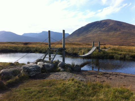
Shortly after crossing a wobbly suspension footbridge (pic above) across the loch inflow, I left the bike and climbed onto and up the easy-sloping ridge of Carn Dearg (1034m) from where there were fine views, both to Ben Alder and more immediately the Lancet Edge, a sharply pyramidal ridge leading up to another Munro I had climbed a few years before. I dropped down below the Lancet Edge, traversing a corrie and a valley at 600m before climbing up 100m to the Long Leachas. This is one of a number of ridges leading onto Ben Alder and it is in a spectacular location. The ridge offers easy scrambling, always with a bypass path. It is scenic and so makes the climb up to 1050m almost effortless. Near the top, it narrows, and keeping to the crest of the ridge offers numerous short and easy scambles over various boulders. From the top of the ridge, it is a 1.5km walk across the plateau to the summit of Ben Alder itself. Just below the summit lies the ruins of a small house – built by the team of the original Ordnance Survey surveying expeditions. Shortly after is a small lochan – at 1100m altitude, presumably one of the highest bodies of water in the UK.
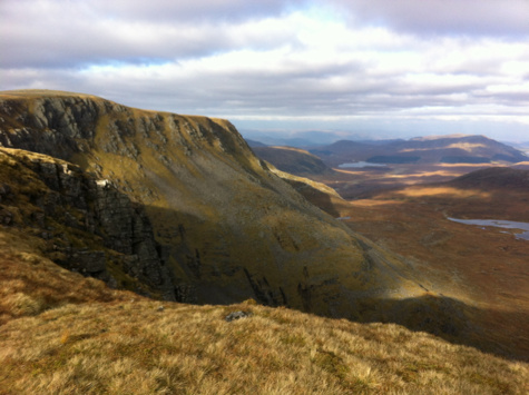
The best views are from the ridge following on from the summit (see pic above), particularly looking north down the cliffs to a large loch and over to the Monadhliath Mountains. Looking the other way, Loch Ossian, with its wonderfully remote youth hostel, is also visible.
It is best not to follow the ridge eastwards too far from Ben Alder’s summit, as it curves around to the north and then ends in cliffs on three sides. So I came off the ridge early, aiming for the high bealach (840m) and then it was a quick ascent up Beinn Bheoil (1019m), the last of the three. There is a small top just to the right, on the way up, that has a fine view over Loch Ericht – the loch is a reservoir, dammed at both ends as it crosses over Scotland’s east/west watershed.
After Beinn Bheoil, I continue northwards along the largely flat and easy ridge, then coming off it to the left and hitting a well made stalkers’ path, that leads down to the river, to a bridge across it near Culra Bothy (now closed) and finally back to Loch Pattack and my bike, exactly six hours after I left. I’d walked 22km and climbed 1450m. The return along the estate road, to catch the evening train home, was done with care, as it was by now twilight.