OpenOrienteeringMap, the easy online tool for creating street orienteering maps from OpenStreetMap data, has been updated to version 3. Development for this version was kindly funded with a grant from the Orienteering Foundation.

New features for version 3 include:
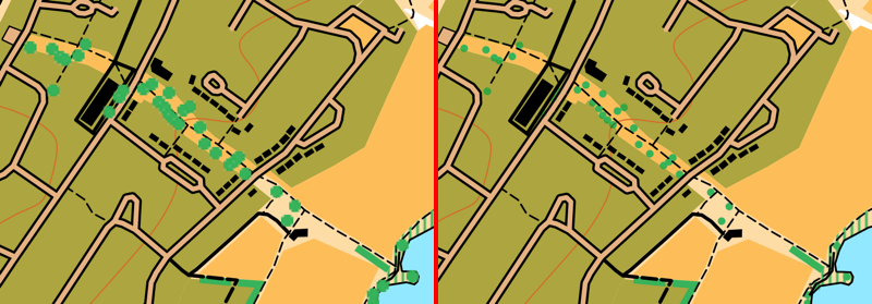
- Better trees! We now use SVG graphics for lone trees (and monuments). This means they are scaled correctly when appearing on the map, both on the screen and on the high quality ready-to-print PDFs. The use of SVGs and better scaling means that the trees now don’t dominate the map at smaller scales. In addition, trees are drawn underneath line features, so that they don’t obscure, for example, path detail. The same treatment is applied to monuments, too. This fixes one of the most requested bugs on the OpenOrienteeringMap Github. See above for the difference – note the better scaling, lack of pixalation, and less obscured paths, on the right!
- Similiar vectorisation improvements have taken place for fences, walls, power lines, cliffs and embankments. These linear features have regularly spaced markings to indicate their type. Previously, these markings used PNG images, which did not work well for the high quality vector PDFs. These have been replaced with SVGs, which scale correctly and print at high quality, through the use of a different kind of Mapnik symbolizer – a MarkerSymbolizer rather than a LinePatternSymbolizer. The only remaining raster graphics that appear on an OpenOrienteeringMap are the fill textures for polygon areas, such as vegetation undergrowth. These use PolygonPatternSymbolizer, which does not support SVGs and has no equivalent symbolizer which does.
- We now include benches, picnic tables and litterbins on the maps. These are shown as small black crosses.
- JPEGs can now be produced for OpenOrienteeringMap. This is very useful for adding OpenOrienteeringMap maps to platforms like Routegadget or OCAD (as background map) where JPEGs are required. PDFs should still be continued to use for printing, as they will result in a much higher quality map, but you no longer need to manually convert to JPEG using an image editor or other additional software.
- In conjunction with the above, geolocation “Worldfiles” can now be produced for OpenOrienteeringMap. These are small config files that allow a JPEG (or PDF) OOM map to appear in the correct place on a location-aware service, such as Google Earth, Mapper from the OpenOrienteering project (not tested) or similar.
- Some of the details from the “Pseud-O” map style on OOM have been ported across to the standard “Street-O” maps. This includes trees, monuments, powerlines, sports pitches and hedges.
- Some layer reordering – contour lines now go across roads and above buildings. The shape of the land is important, and so this change makes it easier to see hills and slopes.
- Buildings on the Pseud-O map style are now shown as grey with black borders, rather than all black as before, this stops them from overwhelming the Pseud-O map in city centres.
- A new style, Blueprint, has been officially launched. This style (see example at top) which was in beta for a while, is different to orienteering maps, as it is designed for people who want to create a map of their local area to colour in! A simple set of very think black lines, with lots of white spaces, is produced, allowing a simple high-quality map of local areas to be produced, ideal for colouring in! Blueprint doesn’t include contour lines and doesn’t allow controls to be added. You can try it out here.
- The global map database has received a bulk update, so now covers changes/additions made to OpenStreetMap up to around early August 2017. The UK database continues to enjoy daily updates (changes appear approximately 48 hours after the corresponding edits in OpenStreetMap).
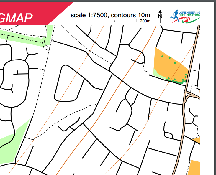
- Branding of the website and the PDF maps has been updated to recognise the support received from the Orienteering Foundation.
- The grant also partially supports the hosting/bandwidth costs associated with OpenOrienteeringMap for the next twelve months.