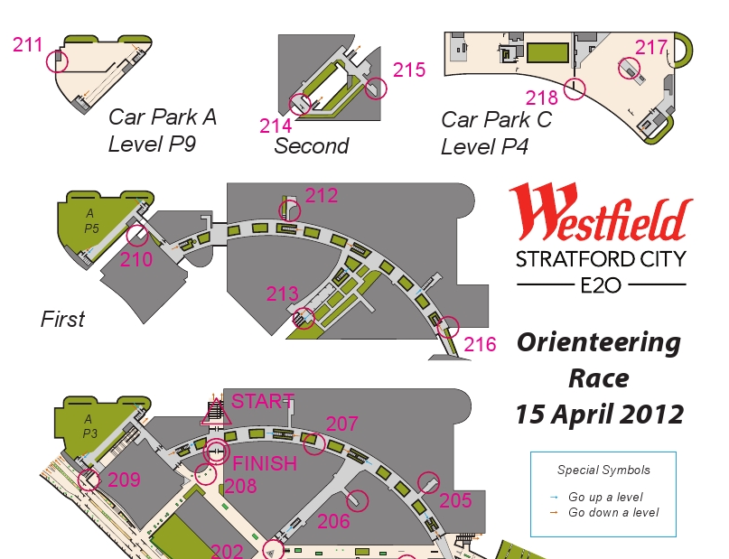
Here’s a map of England, overlaid on it is a choropleth map showing the modal (i.e most common) council tax band within each Census Output Area (OA) in England, based on March 2011 data released by the Office of National Statistics and listed on data.gov.uk.
I’m using a manually created colour ramp instead of a “standard” (i.e. ColorBrewer) diverging or sequential ramp, to emphasise the outliers (the big, expensive Band H houses and the small, cheap Band A ones) and try and reduce the “patchwork quilt” effect that you get when looking at such a map (which has nearly 170000 areas.) Another way to minimise this effect would have been to use larger geographies (LSOAs and MSOAs) at the smaller scales.
The map shows a swathe of light blue Band A housing across the north of England, and in Birmingham. In London, generally this doesn’t happen, and indeed a band of very large, expensive houses, protrudes from the affluant commuter belt right into the centre of London, from the south-west and north.
The map was created using UCL CASA’s MapTube, with a CSV file, descriptor file and stylesheet being the inputs. Welsh council tax bands use a different scale so are not included here. The Scotland/N.I. data is not available through the ONS website.
A gotcha when producing this map is that the file uses the new (2011) identifiers for OAs. Thankfully I found a file that maps the old to the new ones, although it took a bit of sleuthing to find it on the ONS website.
A zoomable, explorable version of the map is available..

 The most interesting sketch presented on the table (and shown on the right – photo by Helen) was built by Steven Gray and connected to a airplane sensor box, that picked up near-real-time broadcasts of location, speed and aircraft ID, of planes flying over London. The sketch stored recently received information, and so was able to project little images of plans, orientated correctly and with trails showing their recent path. Attached to each plane image was a a readout of height and speed, and most innovatively of all, a


 CityDashboard features specially curated Twitter lists. For each city, there is a general news list, featuring tweets from local newspapers, local correspondents for the BBC and other TV and radio channels, tourist organisations and the official accounts for the relevant local authorities. There is also a universities list, with the official Twitter accounts for the main universities in each city, as well as their student unions. It is hoped that this latter list with detail the latest university research outputs, coming out of that city. The account that manages the lists is