I first tried Strava last year, comparing it to Endomondo, RunKeeper and some others, as a way of quickly pushing maps of long bike rides onto Facebook, rather than just keeping them to myself on Ascent (a standalone Mac application which has ceased development) or Garmin Connect (which wasn’t particularly sociable).
I didn’t use Strava in the end, but I’m a big convert now, because I’ve realised that Strava is not just a running/cycling route recording site, but it’s a fully fledged social network – crucially, one which is large enough to actually function as a proper social network – and best of all, they’ve basically turned London’s street network into a giant game, with “segments”. I first heard of this when a friend, who’s an active Strava user, lamenting that the Tour de France riders had wiped out various segment leaders, en masse, as they zoomed through the streets of London during the third stage of this year’s race, as some were GPS’ing their route as they went.
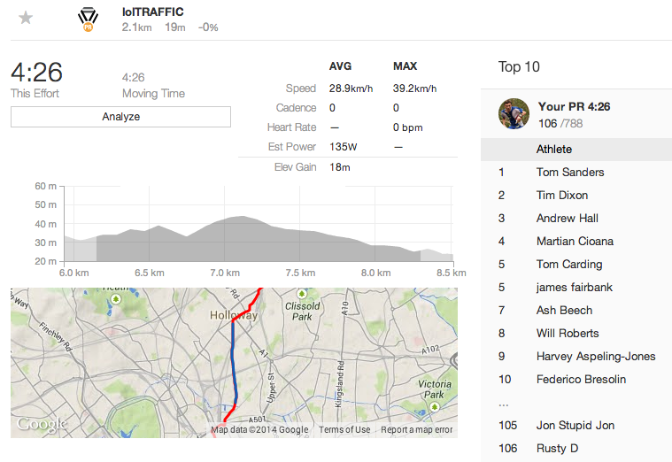
Segments are sections of a street – typically a long, straight section, or between two sets of slow traffic lights, or from the bottom to the top of a hill – which someone has named and designated as a segment. You then have a public leaderboard of who’s cycled/run the segment, plus your own personal statistics for the segments as well.
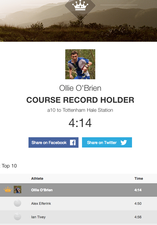
Despite recording my recent commutes, and back-loading various GPS’d runs and cycles into Strava, I don’t have many “CRs” (course records) for segments. But I’m pleased to hold on to two – both runs. One is along a windy road near Seven Sisters. The route/segment matching algorithm doesn’t seem to have minded that I cut a big corner near the end, even though it is obvious on the GPS trace, so has given me a comfortable 40 second cushion. The other was a short uphill section of the North Downs Way, part of a leg I ran during the NDW Relay race that my club takes part in every July. Oddly, it was a section where I made a mistake (due to OpenStreetMap inaccuracies), and veered off the route, only to have the others in the relay go past. I corrected quickly and ran hard to regain the lead, and as a useful bonus it’s given me a CR here too.
Anyway, for cycling, I may struggle to get any CRs soon, as most of these on the commute require cycling over 40km/hour, or more for sprints and descents. I’ll need to get lucky with traffic light timings, and late night empty roads. It might also encourage me to run more (which is good) and cycle faster (probably not so good). in any case, it’s made the commute a lot more fun. Thanks Strava!
4 replies on “Strava – Gamifying the Commute”
[…] Photo credit: eemap.co.uk […]
[…] Gamify The Commute – make it social, and connect people who live nearby or ride the same routes […]
In all the time I lived in France (RERable distance), I never once used the velib, only once cycled into Paris, only and thrice took my bike on the RER: once to get it home from the shop, once returning from the capital to the sticks, and once to send it to England on the train. None of this was followed by GPS.
Hope this helps.
This is quite disappointing.